 Amsterdam, the Netherlands
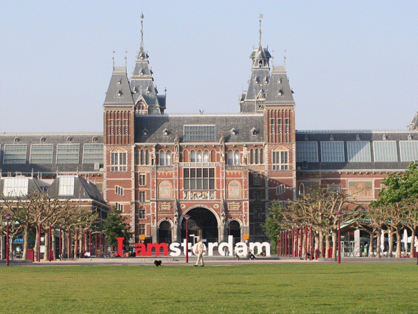
Amsterdam is the capital city and most populous city of the Kingdom of the Netherlands. Its status as the Dutch capital is mandated by the Constitution of the Netherlands though it is not the seat of the Dutch government, which is The Hague. Amsterdam has a population of 813,562 within the city proper, 1,112,165 in the urban area and 1,575,263 in the metropolitan area. The city region has a population of 2,332,773. The city is located in the province of North Holland in the west of the country. It comprises much of the northern part of the Randstad, one of the larger conurbations in Europe, with a population of approximately 7 million. Amsterdam's name derives from Amstelredamme, indicative of the city's origin as a dam of the river Amstel. Originating as a small fishing village in the late 12th century, Amsterdam became one of the most important ports in the world during the Dutch Golden Age (17th century), a result of its innovative developments in trade. During that time, the city was the leading center for finance and diamonds. In the 19th and 20th centuries, the city expanded, and many new neighborhoods and suburbs were planned and built. The 17th-century canals of Amsterdam and the 19–20th century Defence Line of Amsterdam are on the UNESCO World Heritage List. As the commercial capital of the Netherlands and one of the top financial centres in Europe, Amsterdam is considered an alpha world city by the Globalization and World Cities (GaWC) study group. The city is also the cultural capital of the Netherlands. Many large Dutch institutions have their headquarters there, and seven of the world's 500 largest companies, including Philips and ING, are based in the city. In 2012, Amsterdam was ranked the second best city in which to live by the Economist Intelligence Unit (EIU) and 12th globally on quality of living by Mercer. The city was previously ranked 3rd in innovation by 2thinknow in the Innovation Cities Index 2009. Famous Amsterdam residents included Anne Frank the diairist, the artist Vincent Van Gogh, and the philosopher Baruch Spinoza. The Amsterdam Stock Exchange, the oldest stock exchange in the world, is located in the city center. Amsterdam's main attractions, including its historic canals, the Rijksmuseum, the Van Gogh Museum, Stedelijk Museum, Hermitage Amsterdam, Anne Frank House, Amsterdam Museum, its red-light district, and its many cannabis coffee shops draw more than 3.66 million international visitors annually. More information is available on Wikipedia
Today we feature the city of Amsterdam, a seaport, constitutional capital, and principal city in the Netherlands. It is located in the North Holland Province, on the IJ (an arm of the IJsselmeer), near The Hague. The seat of national government, however, is in The Hague. Amsterdam is divided by canals into approximately 90 islands, joined by around 400 bridges. Almost the entire city rests on a foundation of piles driven through peat and sand to a firm substratum of clay. These images acquired by the Landsat 5 and 8 satellites have a time window of acquisition (before / after) of twenty eight years and aim to show the urban difference from 1986 until today. In fact the two images show how the areas around the city have experienced large growth in urban development during this period. Another aim of these images is to promote the opportunity to download Landsat data through the ESA portals, where images captured every day are made available in near real time to the users and the scientific community. Landsat full resolution data products are freely available for immediate download at: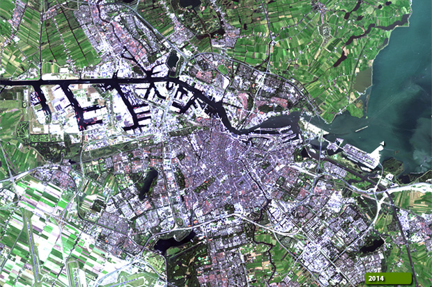 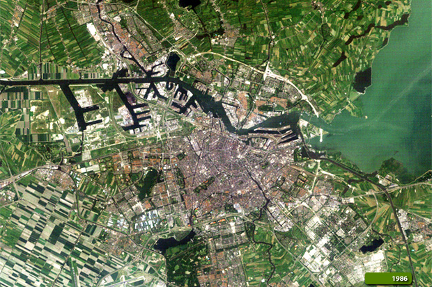 View Landsat 5 TM high resolution image (JPG 1.7 MB) View Landsat 8 OLI high resolution image (JPG 1.6 MB)
These images acquired by the Sentinel-1 satellite in October and November 2014, show the city of Amsterdam, using a merge combination of three radar images. The aim of this image is to promote this new radar satellite space mission from ESA in the Copernicus Programme, which consists of a constellation of two satellites, the first of which was launched in April 2014. This merge image also aims to demonstrate the future monitoring of Earth which the Sentinel satellites will perform. The payload of Sentinel-1 is a Synthetic Aperture Radar in C-band that provides continuous imagery (day, night and all weather). More information is available on Wikipedia  View Sentinel-1 high resolution merge (JPG 2.7 MB)
|
|||||||||||||||||||||||||||||||||||||