 Aktau, Kazakhstan
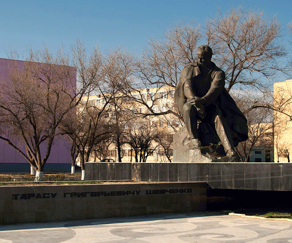
Aktau was known as Shevchenko from 1964 to 1991. Its current name means "white mountain" in Kazakh, which may be due to its cliffs that overlook the Caspian. Its former name was given due to the eponymous Ukrainian poet's period of exile in the area. It is the second largest city in western Kazakhstan and the country's main seaport on the Caspian Sea. It is located on the Mangyshlak Peninsula and is the capital of Mangystau Region. Population: 166,962 (2009 Census results); 143,396 (1999 Census results). Aktau is known for its unique block address system. Almost all streets inside the city have no names, and addresses in Aktau generally consist of three numbers: the district number (also known as micro-region/micro-district/block), the building number, and the apartment number. This is because Aktau was originally planned as a camp for the workers of the oil industry. More information is available on Wikipedia
Today our tour stops over the city of Aktau, the capital of Mangystau oblast in Kazakhstan. Situated along the south-western coastline of the country, to the east of the Caspian sea, the city presents a unique case in the history of town planning. A maximum of comfort has been provided for its residents despite the harsh climatic conditions. The residential area is separated from the industrial zone by a shelterbelt. Aktau is only a little more than 40 years old, but it already has everything necessary for a normal life. The city has several cultural centres, a concert hall, cinemas and dozens of libraries, gyms and sports grounds. One may stroll the city streets for hours on end, admiring the architectural ensembles, green alleys lined with poplars and acacias, emerald-green lawns and a park. In 1978 the International Union of Architects awarded the group of Aktau city planners who had worked out the general layout of Aktau city the prize named after the outstanding urban planner Leslie Patrick Abercrombie. The city also has a botanical garden where plants from various parts of Kazakhstan are getting acclimatised. Today in the city there are over 25 square metres of greenery per resident, which is above the national average. In relation to that, these images, acquired by the Landsat 5 and 8 satellites with an acquisition time window (before / after) of twenty-seven years, aim to show the urban difference as we see in the overlay of the images. Another aim of these images is to promote the opportunity to download Landsat data through the ESA portals, where images captured every day are made available in near real time to the users and the scientific community. Landsat full resolution data products are freely available for immediate download at: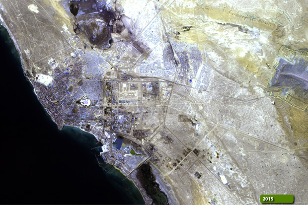 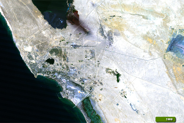 View Landsat 5 TM high resolution image (JPG 746 KB) View Landsat 8 OLI high resolution image (JPG 979 KB)
|
|||||||||||||||||||||