 Tel Aviv, Israel
Tel Aviv or Tel Aviv-Yafo is the second most populous city in Israel, after Jerusalem, with a population of 414,600. It is located on the Mediterranean coast in central-west Israel, within Gush Dan, Israel's largest metropolitan area, containing 42% of Israel's population. It is also the largest and most populous in Gush Dan, which is collectively home to 3,464,100 residents. The city is governed by the Tel Aviv-Yafo municipality. Residents of Tel Aviv are referred to as Tel Avivim (singular: Tel Avivi). Tel Aviv is home to many foreign embassies. Tel Aviv was founded by the Jewish community on the outskirts of the ancient port city of Jaffa (Hebrew: Yafo) in 1909. Immigration by mostly Jewish refugees meant that the growth of Tel Aviv soon outpaced Jaffa's, which had a majority Arab population at the time. Tel Aviv and Jaffa were merged into a single municipality in 1950, two years after the establishment of the State of Israel. Tel Aviv's White City, designated a UNESCO World Heritage Site in 2003, comprises the world's largest concentration of Bauhaus buildings. Tel Aviv is a global city, a technological and economic hub, home to the Tel Aviv Stock Exchange, corporate offices and research and development centres. It is the country's financial capital and a major performing arts and business centre. Tel Aviv has the second-largest economy in the Middle East after Dubai, and is the 31st most expensive city in the world. With 2.5 million international visitors annually, Tel Aviv is the fifth-most-visited city in the Middle East. Known as "The City that Never Sleeps" and a "party capital", it has a lively nightlife, dynamic atmosphere and a famous 24-hour culture. More information is available on Wikipedia
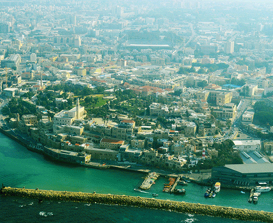
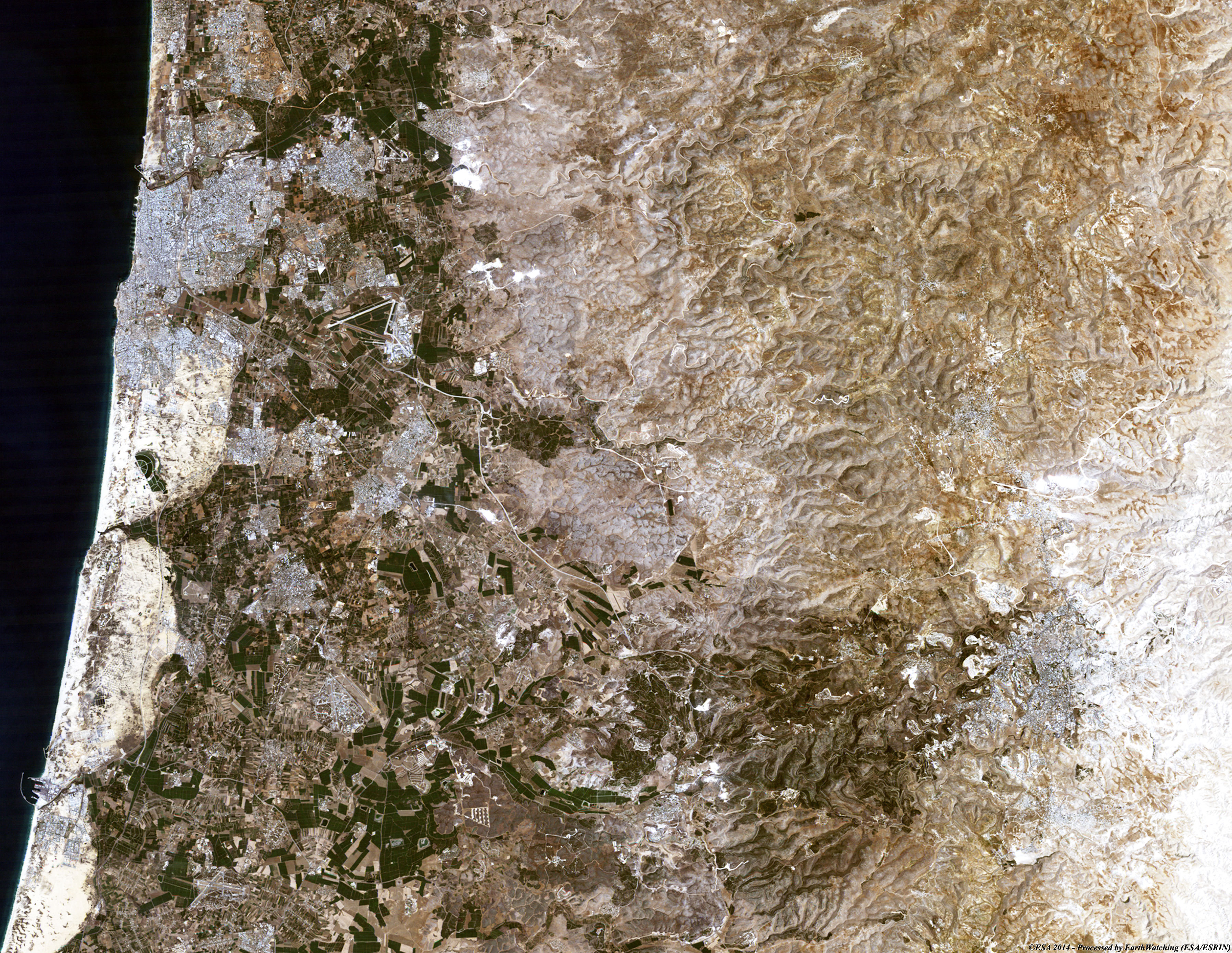
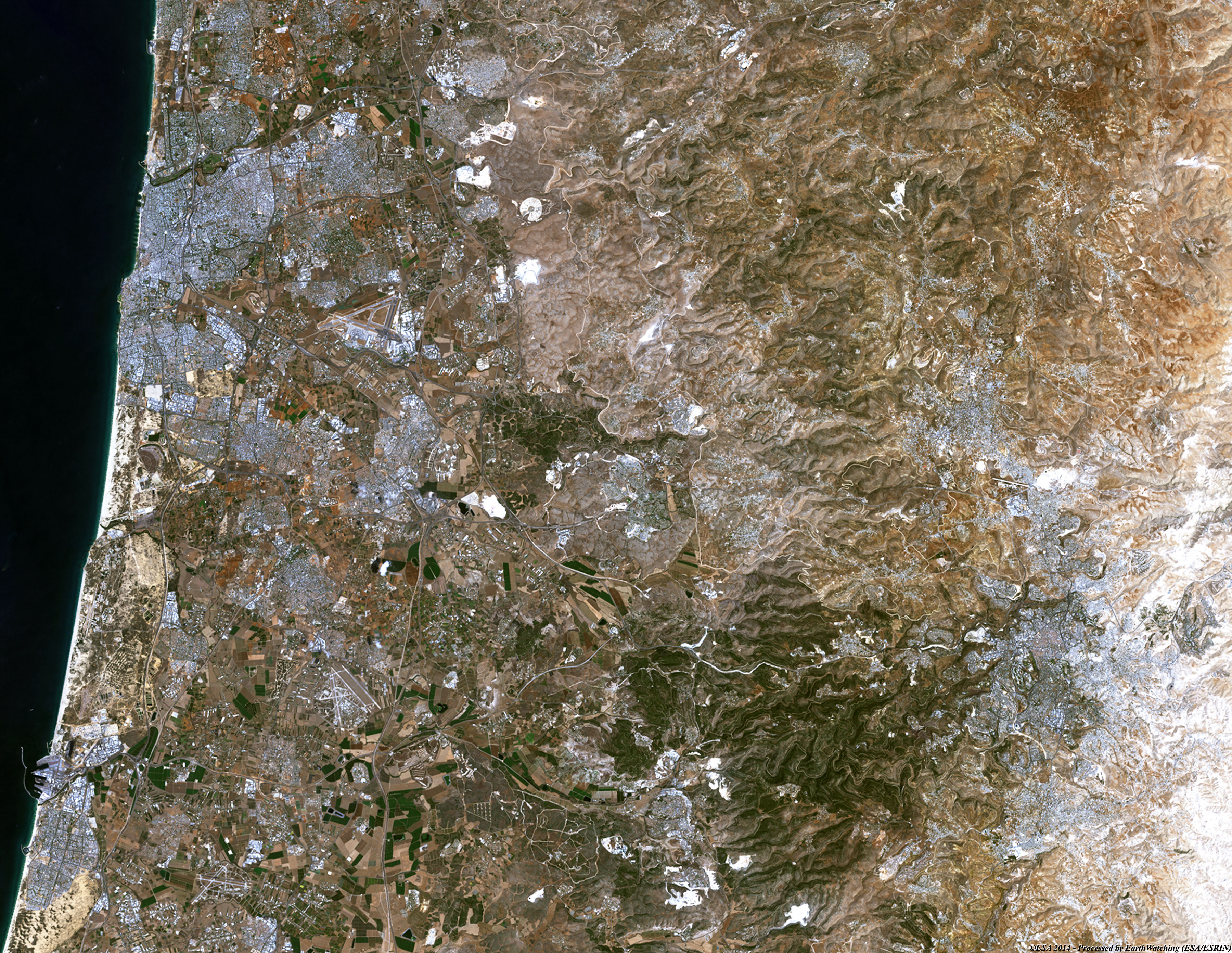
Today we feature the city of Tel Aviv, located on the Israeli Mediterranean coastline, in central Israel, the historic land bridge between Europe, Asia and Africa. Immediately north of the ancient port of Jaffa, Tel Aviv lies on land that used to be sand dunes and as such has relatively poor soil fertility. The land has been flattened and has no important gradients; its most notable geographical features are bluffs above the Mediterranean coastline and the Yarkon River mouth. Because of the expansion of Tel Aviv and the Gush Dan region, absolute borders between Tel Aviv and Jaffa and between the city's neighborhoods do not exist. The city is located 60 kilometres northwest of Jerusalem and 90 kilometres south of the city of Haifa. Neighbouring cities and towns include Herzliya to the north, Ramat HaSharon to the northeast, Petah Tikva, Bnei Brak, Ramat Gan and Giv'atayim to the east, Holon to the southeast, and Bat Yam to the south. The city is economically stratified between the north and south. Southern Tel Aviv is considered less affluent than Northern Tel Aviv with the exception of Neve Tzedek and some recent development on Jaffa beach. Central Tel Aviv is home to Azrieli Center and the important financial and commerce district along Ayalon Highway. The northern side of Tel Aviv is home to Tel Aviv University, Hayarkon Park, and upscale residential neighborhoods such as Ramat Aviv and Afeka. These images acquired by the Landsat 5 and 8 satellites, both acquired in August, have a temporal window of acquisition (before / after) of 30 years and aim to show the large urban development in the inland of the city, especially in the south east and along the coast. Another notable location in the images is the city of Jerusalem, visible in the lower right; the time span between the two images shows that this city has also had large urban changes in the north area since 1984. Another aim of these images is to promote the opportunity to download Landsat data through the ESA portals, where images captured every day are made available in near real time to the users and the scientific community. Landsat full resolution data products are freely available for immediate download at: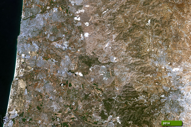 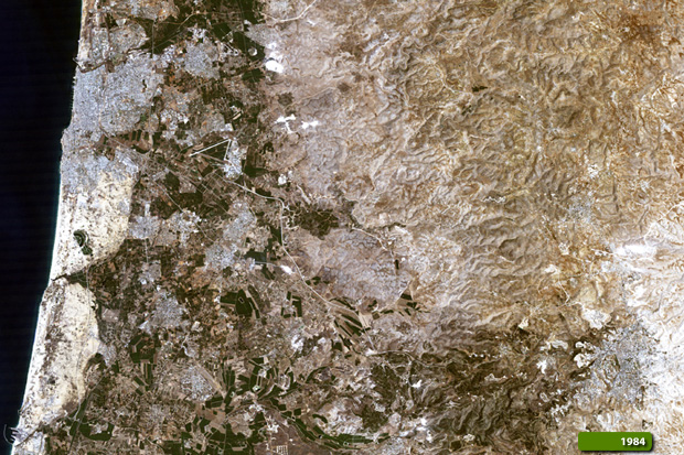 View Landsat 5 TM high resolution image (JPG 2.7 MB) View Landsat 8 OLI high resolution image (JPG 2.6 MB)
|
|||||||||||||||||||||