 Mount Vesuvius fire
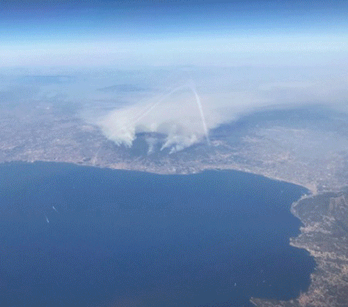
Since last week, Mount Vesuvius has been engulfed by large clouds of smoke, coming not from the volcano, but from a series of wildfires along its slopes. The fires are believed to be mostly intentional in origin (to clear the ground), but the hot and dry weather helped to rapidly spread the fires. Most of the fires are now under control, however, geologists fear that the worst is yet to come. According to a preliminary evaluation, almost 3.5 square miles of forest were destroyed completely, 2.7 square miles were severely damaged and another 2.5 square miles were touched by the flames. Residential areas were affected, but no damage or fatalities were reported. In all, about 7 square miles were affected by the wildfires. The fire destroyed large areas of vegetation, exposing the volcanic rock to erosion. As Vesuvius is a strato volcano, composed of alternating layers of hard lava and loose volcanic ash, mudflows could now form along the slopes during heavy rainfall. Especially vulnerable are the northern slopes, below the rim of the crater, formed during the 79 AD eruption. Many streets leading to the volcano were built crossing former erosion channels, characterizing all the slopes of the mountain. Read more on Forbes
These images acquired through a combination of optical bands in visible colour and in false colour by Sentinel-2 (part of the Copernicus project), show the area of Vesuvius (Italian, Vesuvio), the famous volcano in southern Italy. Near the shore of the Bay of Naples and the city of Naples, it is covered by a plume of smoke which rises from wildfires burning on the slopes of the mountain. In the comparison it is easy to see the large area of forest around the volcano which has been burnt by the fire. The area burned (noted with a caption) is visible in black in the images in false colour bands while in the image in bands combination 4, 3, 2, (visible colour) the large areas where the fire is still burning are visible. Another area struck by the fires is visible along the Amalfi Coast, where a big area is completely covered by a plume of smoke (see the centre lower part of the image). 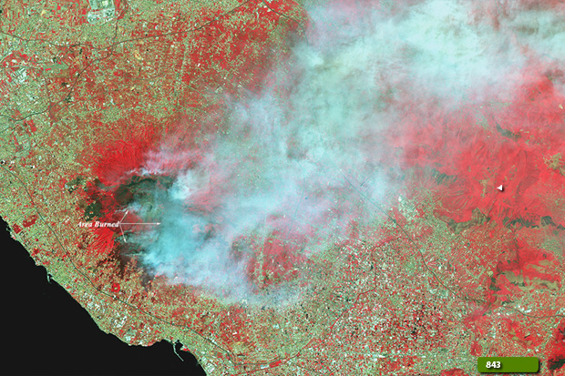 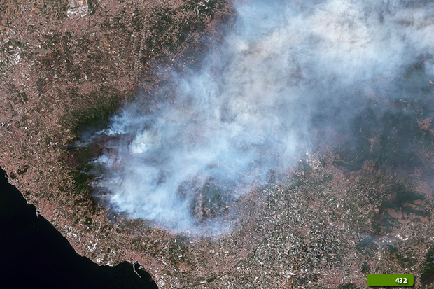 View Sentinel-2 large format slider View high resolution image in bands 4, 3, 2 (JPG 9.0 MB) View high resolution image in bands 8, 4, 3 (JPG 9.7 MB)
|
|||||||||||||||||