 Barcelona, Spain
Barcelona is the capital and largest city of Catalonia, and the second most populous municipality of Spain. With a population of 1.6 million within city limits, its urban area extends to numerous neighbouring municipalities within the province of Barcelona and is home to around 4.7 million people, making it the sixth most populous urban area in the European Union after Paris, London, Madrid, the Ruhr area and Milan. It is the largest metropolis on the Mediterranean Sea, located on the coast between the mouths of the rivers Llobregat and Besòs, and bounded to the west by the Serra de Collserola mountain range, the tallest peak of which is 512 metres high. Founded as a Roman city, in the Middle Ages Barcelona became the capital of the County of Barcelona. After merging with the Kingdom of Aragon, Barcelona continued to be an important city in the Crown of Aragon as an economic and administrative centre of this Crown and the capital of the Principality of Catalonia. Barcelona has a rich cultural heritage and is today an important cultural centre and a major tourist destination. Particularly renowned are the architectural works of Antoni Gaudí and Lluís Doménech i Montaner, which have been designated UNESCO World Heritage Sites. The headquarters of the Union for the Mediterranean is located in Barcelona. The city is known for hosting the 1992 Summer Olympics as well as world-class conferences and expositions and also many international sport tournaments. Barcelona is one of the world's leading tourist, economic, trade fair and cultural centres, and its influence in commerce, education, entertainment, media, fashion, science, and the arts all contribute to its status as one of the world's major global cities. It is a major cultural and economic centre in southwestern Europe, 24th in the world (before Zürich, after Frankfurt) and a financial centre. In 2008 it was the fourth most economically powerful city by GDP in the European Union and 35th in the world with GDP amounting to €177 billion. In 2012 Barcelona had a GDP of $170 billion; and it was leading Spain in employment rate in that moment. In 2009 the city was ranked Europe's third and one of the world's most successful as a city brand. In the same year the city was ranked Europe's fourth best city for business and fastest improving European city, with growth improved by 17% per year, and the city has been experiencing strong and renewed growth for the past three years. Since 2011 Barcelona has been a leading smart city in Europe. Barcelona is a transport hub, with the Port of Barcelona being one of Europe's principal seaports and busiest European passenger port, an international airport, Barcelona–El Prat Airport, which handles over 40 million passengers per year, an extensive motorway network, and a high-speed rail line with a link to France and the rest of Europe. More information is available on Wikipedia.
Today we focus our tour over the city of Barcelona, which is located in north-east of Spain. It is the capital city of the autonomous region of Catalonia, on the coast of the Mediterranean Sea between the Llobregat and Besós rivers. Barcelona is the second-largest Spanish city in population and the principal industrial and commercial centre of the country. It is is surrounded by mountains, with fertile plains and a sandy coast. The aim of these images acquired by the Landsat family, with a time window (before/after) of 33 years, is to show how significantly Barcelona has changed since 1984. The skyline of the city has developed with new areas constructed, particularly along the coast where the harbour is located. Barcelona Airport has also undergone major development with new construction of infrastructure and runways. Another aim of these images is to promote the opportunity to download Landsat data through the ESA portals (or third party mission free catalogue), where images captured every day are made available in near real time to the users and the scientific community. Landsat full resolution data products are freely available for immediate download at: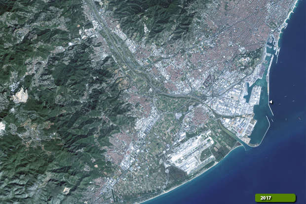 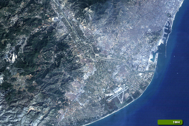 View Landsat 5 TM high resolution image (JPG 4.0 MB) View Landsat 8 OLI high resolution image (JPG 3.1 MB)
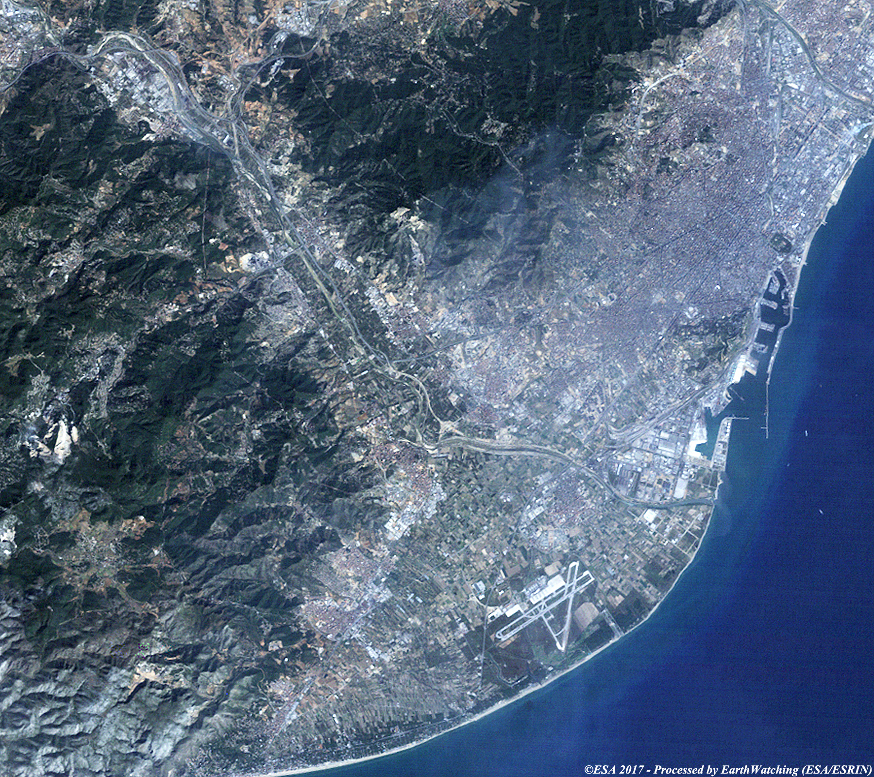
This Sentinel-2 image shows Barcelona and demonstrates the high quality of optical imagery produced by this satellite in the Copernicus programme.  View high resolution image (JPG 7.0 MB)
|
||||||||||||||||||||||||||||||||||