 Seine Bay, Normandy - 70 years after D-Day
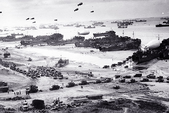
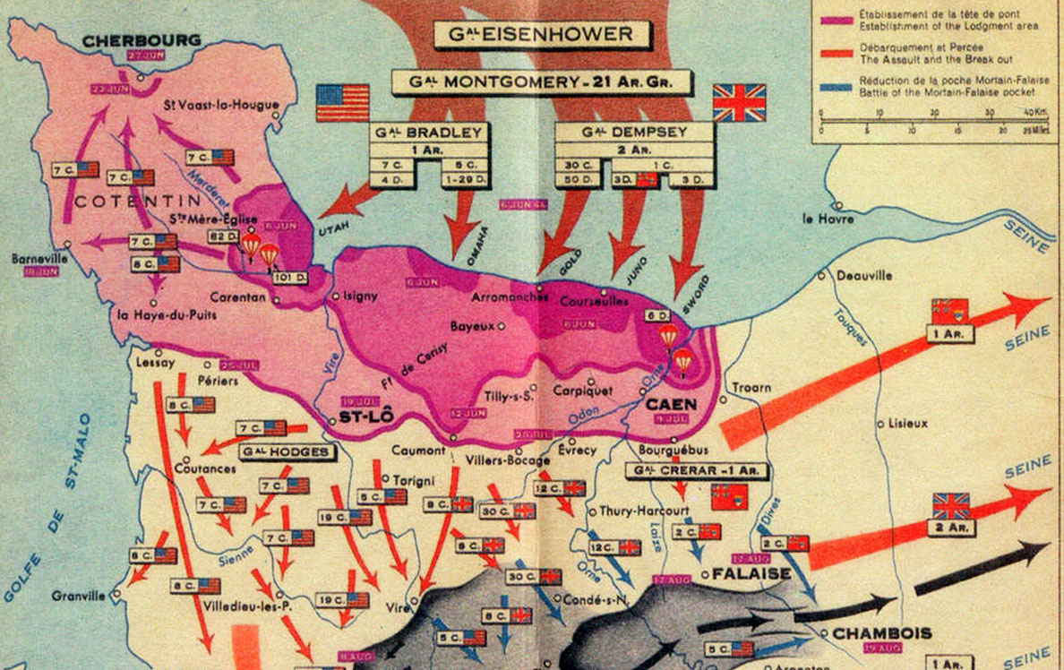
The Invasion of Normandy, was the invasion by and establishment of Western Allied forces in Normandy, during Operation Overlord in 1944 during World War II; the largest amphibious invasion to ever take place. D-Day, the day of the initial assaults, was Tuesday 6 June 1944. Allied land forces that saw combat in Normandy on that day came from Canada, the Free French Forces, the United Kingdom, and the United States. In the weeks following the invasion, Polish forces also participated, as well as contingents from Belgium, Czechoslovakia, Greece, and the Netherlands. Most of these countries also provided air and naval support, as did the Royal Australian Air Force, the Royal New Zealand Air Force, and the Royal Norwegian Navy. The Normandy invasion began with overnight parachute and glider landings, massive air attacks and naval bombardments. In the early morning, amphibious landings on five beaches codenamed Juno, Gold, Omaha, Utah, and Sword began and during the evening the remaining elements of the parachute divisions landed. Land forces used on D-Day deployed from bases along the south coast of England, the most important of these being Portsmouth.
 Allied forces rehearsed their D-Day roles for months before the invasion. On 28 April 1944, in south Devon on the English coast, 638 U.S. soldiers and sailors were killed when German torpedo boats surprised one of these landing exercises, Exercise Tiger. In the months leading up to the invasion, the Allied forces conducted a deception operation, Operation Fortitude, aimed at misleading the Germans with respect to the date and place of the invasion. There were several leaks prior to or on D-Day. Through the Cicero affair, the Germans obtained documents containing references to Overlord, but these documents lacked all detail. Double cross agents, such as the Spaniard Joan Pujol (code named Garbo), played an important role in convincing the German High Command that Normandy was at best a diversionary attack. U.S. Major General Henry Miller, chief supply officer of the US 9th Air Force, during a party at Claridge's Hotel in London complained to guests of the supply problems he was having but that after the invasion, which he told them would be before 15 June, supply would be easier. After being told, Eisenhower reduced Miller to lieutenant colonel [Associated Press, June 10, 1944] and sent him back to the U.S. where he retired. Another such leak was General Charles de Gaulle's radio message after D-Day. He, unlike all the other leaders, stated that this invasion was the real invasion. This had the potential to ruin the Allied deceptions Fortitude North and Fortitude South. In contrast, Gen. Eisenhower referred to the landings as the initial invasion. Only ten days each month were suitable for launching the operation: a day near the full moon was needed both for illumination during the hours of darkness and for the spring tide, the former to illuminate navigational landmarks for the crews of aircraft, gliders and landing craft, and the latter to expose defensive obstacles placed by the German forces in the surf on the seaward approaches to the beaches. A full moon occurred on 6 June. Allied Expeditionary Force Supreme Commander Dwight D. Eisenhower had tentatively selected 5 June as the date for the assault. The weather was fine during most of May, but deteriorated in early June. On 4 June, conditions were clearly unsuitable for a landing; wind and high seas would make it impossible to launch landing craft from larger ships at sea, low clouds would prevent aircraft finding their targets. The Allied troop convoys already at sea were forced to take shelter in bays and inlets on the south coast of Britain for the night. It seemed possible that everything would have to be cancelled and the troops returned to their embarkation camps (which would be almost impossible, as the enormous movement of follow-up formations into them was already proceeding). The next full moon period would be nearly a month away. At a vital meeting on 5 June, Eisenhower's chief meteorologist (Group Captain J.M. Stagg) forecast a brief improvement for 6 June. Commander of all land forces for the invasion General Bernard Montgomery and Eisenhower's Chief of Staff General Walter Bedell Smith wished to proceed with the invasion. Commander of the Allied Air Forces Air Chief Marshal Leigh Mallory was doubtful, but Allied Naval Commander-in-Chief Admiral Bertram Ramsay believed that conditions would be marginally favourable. On the strength of Stagg's forecast, Eisenhower ordered the invasion to proceed. As a result, prevailing overcast skies limited Allied air support, and no serious damage would be done to the beach defences on Omaha and Juno. The Germans meanwhile took comfort from the existing poor conditions, which were worse over Northern France than over the English Channel itself, and believed no invasion would be possible for several days. Some troops stood down and many senior officers were away for the weekend. Field Marshal Erwin Rommel took a few days' leave to celebrate his wife's birthday, while dozens of division, regimental and battalion commanders were away from their posts conducting war games just prior to the invasion.
This image acquired over the coast of Normandy (Seine Bay) by the Landsat 8 satellite almost 70 years after D-Day, aims to show the area where on 06 June 1944 the Allied troops commanded by Eisenhower, started the invasion of Normandy's coast. Another aim of these images is to promote the opportunity to download Landsat data through the ESA portals, where images captured every day are made available in near real time to the users and the scientific community. Landsat full resolution data products are freely available for immediate download at: View Landsat 8 OLI high resolution image (JPG 8 MB)
|
||||||||||||||||||||||