 Asset Publisher
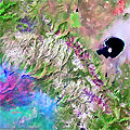
Yosemite National Park (California, USA) - Fire, September 2013These multispectral images acquired by the Landsat 8 satellite over the Yosemite National Park in California, show the large fire that broke out in the park on 20 August 2013. 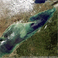
Algal blooms in Lake Erie (North America)The green scum shown in these images is the worst algae bloom Lake Erie has experienced in decades. Such blooms were common in the lake's shallow western basin in the 1950s and 60s. Phosphorus from farms, sewage, and industry fertilised the waters so that huge algae blooms developed year after year. 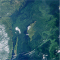
Algal blooms phenomenon (Baltic Sea)These satellite images, acquired from Envisat's MERIS_FR sensor, show a vast algal bloom that could pose a risk to marine life in the Baltic Sea. The blue-green bloom, which stretches from Finland to parts of Germany and Poland, is the largest scientists have seen in the Baltic in recent years. They believe a prolonged stretch of warm sea temperatures and a lack of wind, coupled with fertiliser from regional agriculture washing into the Baltic, have caused the bloom. 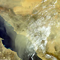
Sandstorm in Yemen and Saudi ArabiaA powerful sandstorm blew over the Persian Gulf in March 2012. The storm caused hundreds of people to go to the hospital for respiratory problems, and air traffic was disrupted for the duration of the storm. 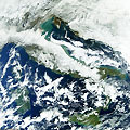
Italy covered with snow - February 2012This series of Envisat images, acquired by the MERIS instrument, show the heavy snow that fell over Italy in February 2012. 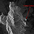
Giglio Island, Italy (Cruise ship accident) - January 2012This series of Envisat radar images examine Giglio Island, where the Costa Concordia cruise ship ran aground on 13 January 2012. 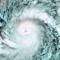
Hurricane Season 2011This series of Envisat MERIS and ASAR images look at some of the Atlantic hurricanes that were a part of 2011's Hurricane Season. 
Sandstorm in Iran - April 2011These Envisat images, acquired by the MERIS instrument, show the sandstorm that struck Iran in April 2011, causing severe disruption and hospitalising over a hundred people. 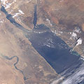
Sandstorm in Egypt - December 2010This Envisat image, acquired by the MERIS instrument, shows a sandstorm over Egypt in December 2010. Driven by strong winds, the sand caused disruption and reduced visibility for people in the affected areas. 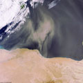
Sandstorm in Libya - March 2007This MERIS Full Resolution image was acquired in near real time over the Gulf of Sidra (Libya) where a large sandstorm is visible along the coast. 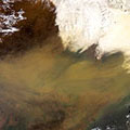
Sandstorm in China - April 2006This Medium Resolution Imaging Spectrometer (MERIS) image was acquired by Envisat on 17 April 2006 and shows a sandstorm that swept over Beijing. 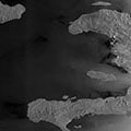
Haiti and surroundings - June 2004This Envisat ASAR (orbit 11788) wide-swath radar image (400km wide) was acquired at Kiruna on 01 June 2004 during the flooding over Haiti. |
||