China, July 1998 - Seasonal summer rains have devastated vast areas of China this year, killing more than 2,000 people, destroying 2.9 million houses and ruining more than 9 million hectares of crops.
During the first week of August new rains in central Hubei and Hunan provinces pushed water levels of the Yangtze to a third peak and cut power supplies to Hubei's provincial capital Wuhan where water levels have risen to 1.25 meters above danger level. Towards the end of July torrential rains lashed central China causing the first serious flood.
|
Event Timeline |
|
ERS-2 SAR Satellite images |
|
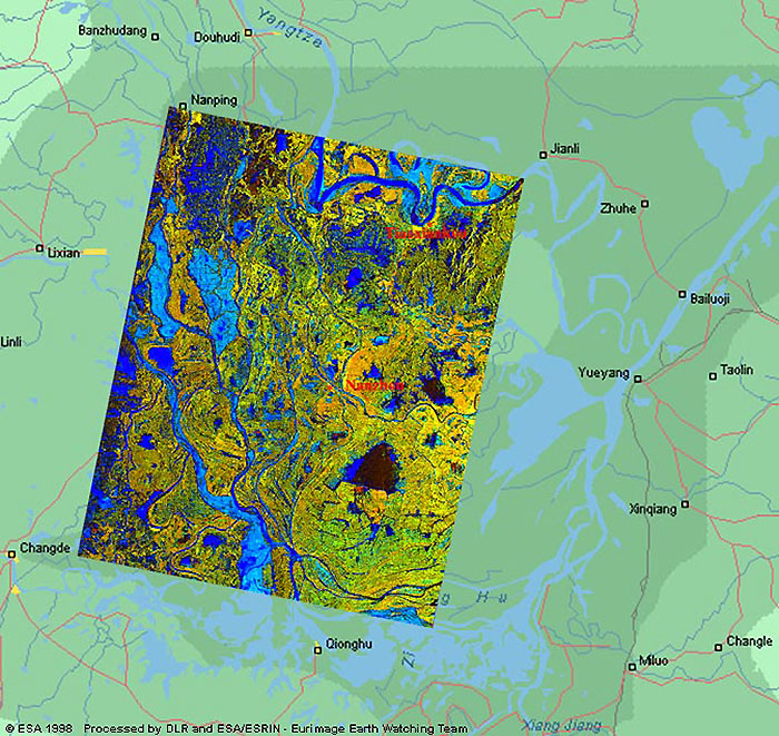
These images were acquired during the floods in China at the station of Ulan Bator (Mongolia).
|
|
This image was acquired on 01 August 1998 over Huarong (200km south-west of Wuhan), and the Yangtze River. The image is superimposed and uses a semi-transparent layer which highlights the river in light blue.
|
|
Superimposed image
|
|
Technical Information |
|
Satellite: |
ERS-2 |
|
Instrument: |
Synthetic Aperture Radar (SAR) |
|
Area coverage: |
180 X 100 km |
|
Date of Acquisition: |
(ERS-2) 01 August 1998 |
|
Acquired by: |
Ulan Bator (Mongolia) 1998 |
|
This image was created using two SAR acquisitions (09 June 1993 – 01 August 1993) which have been superimposed to highlight the normal and flooded situations. The dark and light shades of blue represent the conditional changes;
Key:
-
Dark blue – Normal situation
-
Light blue – Flooded situation
|
|
Superimposed image - Normal/Flooded situation
|
|
Technical Information |
|
Satellite: |
ERS-2 |
|
Instrument: |
Synthetic Aperture Radar (SAR) |
|
Area coverage: |
100 X 80 km |
|
Date of Acquisition: |
(ERS-1) 09 June 1993 – (ERS-2) 01 August 1998 |
|
Orbits: |
(ERS-1) 9925, (ERS-2) 17149 |
|
Frame: |
(ERS-1/2) 3015, 2997 |
|
Acquired by: |
Hatoyama (Japan) 1993, Ulan Bator (Mongolia) 1998 |
 Browse SAR Events by Year