- All Categories (25566)
- Data (1)
- News (40)
- Missions (26)
- Events (14)
- Tools (1)
- Activities (4)
- Campaigns (2)
- Documents (25478)
News - Success Stories

Publication of Coastal Current Intrusions from Satellite Altimetry
A new study entitled “Coastal current intrusions from satellite altimetry” has just been published in the journal Remote
News - Success Stories

Long-term satellite data show wind farms can affect local air currents
Long-term measurements allow before and after comparison Data from the heritage Envisat satellite currently maintained accessible
Event - Workshop

2nd Space for Hydrology Workshop
The workshop aimed to assess the current stage of knowledge and activities in space-based hydrological observations and to
News - Success Stories
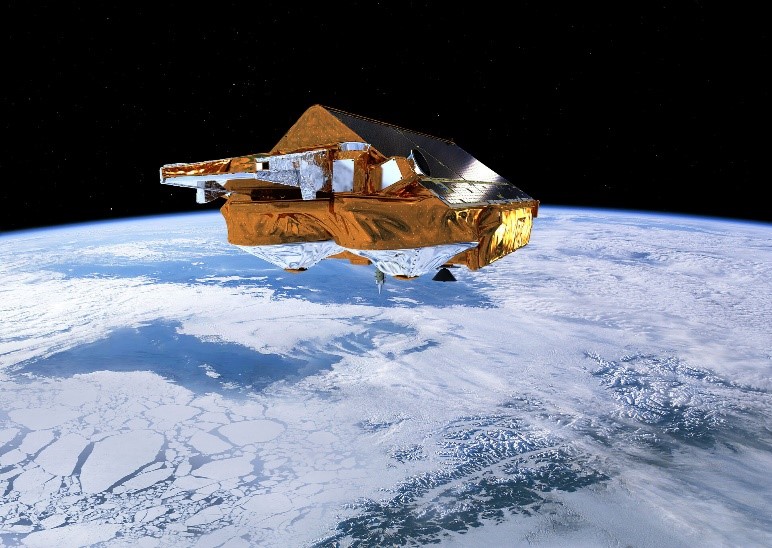
CRYO2ICE over Antarctica: revealing further insight on changing ice
The CryoSat-2 satellite is currently being aligned with ICESat-2 over Antarctica, unlocking fresh possibilities in the wealth
News - Success Stories
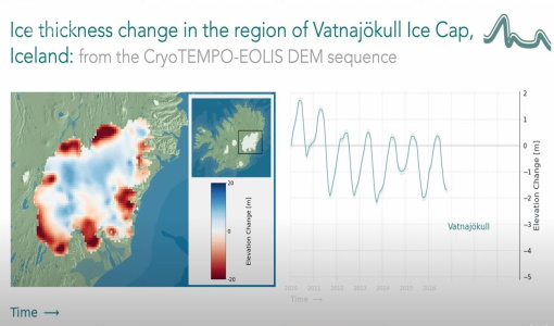
CryoTEMPO-EOLIS Products Now Available for Iceland, Svalbard, and the Canadian Arctic
Land-ice monitoring via Earth Observation methods in general, and altimetry in particular, are essential for tracking the current
Data - EO Sign In Authentication (Open)
Envisat ASAR WS Single Look Complex L1 [ASA_WSS_1P]
for INSAR applications based either on wide-swath/wide-swath pairs or wide-swath/image mode pairs, applications of ocean current
Activity - Quality

EDAP
The following missions are currently being considered as part of the Automatic Identification System (AIS) and Radio Frequency
News - Success Stories

10 years of Envisat data help to illuminate ocean processes
, a surface oceanic current that forms the western boundary current of the southern Indian Ocean [2].
Tools - Analysis

GOCE User Toolbox
Data output formats The current data formats that GUT can provide in output are: netCDF (Climate and Forecast Metadata Convention
Event - Workshop

SEASAR 2012
Aouf 14:00 - 14:20 Towards consistent inversion of wind, waves and surface current from SAR Bertrand Chapron (IFREMER, France
Event - Training

EO Summer School 4
Keynote lectures on global change issues are also given to discuss the current state of the science of global change and
News - General News
ESA's excellent Earth Explorer missions extended to 2025
Acting like the spinning conductor in a bicycle dynamo, it generates electrical currents and thus the continuously changing
News - Operational News

Delay in the availability of CryoSat Products
There is currently an ongoing technical issue at the CryoSat Payload Data Ground Segment (PDGS).
Document - Conference Presentation - Poster

2-Monitoring-surface-inflow-Atlantic-Water-Nordic-Seas.pdf
On the origin of short internal waves trailing strong internal solitary waves observed on spaceborne SAR images acquired over the northern South China Sea Werner Alpers (University of Hamburg, Germany)
Document - Conference Presentation - Poster
7-Highres-Surface-Velocity-Monitoring-Wide-Swath-SAR.pdf
High resolution Surface Velocity Monitoring with Wide Swath SAR: A User´s Guide to the Range Doppler Method Johnny Johannessen (NERSC, Norway)
Mission - Earth Explorers
Geographical Mode Mask
The current operational Geographical Mode Mask v5.0 The current version of the geographical mode mask v5.0 has been in operation
Document - Proceedings

SEASAR-2012-sessions-summaries-seed-questions-recommendations.pdf
This document gathers together the sessions summaries with seed questions discussion and recommendations of the SEASAR 2012 workshop.
Event - Workshop
SEASAR 2006
requirements Formulate recommendations for algorithm and new products development To present ESA studies results on wind, wave and currents
Event - Workshop
SEASAR 2008
of the workshop were: Wave mode processing algorithms, product validation and assimilation Ocean Wind applications Ocean Current
News - Data Release news

CryoSat Ocean Baseline C reprocessed data available
The reprocessing activity is currently progressing and we are planning to publish batches of six months of data every 20