- All Categories (35)
- News (19)
- Missions (14)
- Documents (2)
News - Success Stories
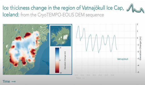
CryoTEMPO-EOLIS Products Now Available for Iceland, Svalbard, and the Canadian Arctic
Land-ice monitoring via Earth Observation methods in general, and altimetry in particular, are essential for tracking the current
News - General News
ESA's excellent Earth Explorer missions extended to 2025
Acting like the spinning conductor in a bicycle dynamo, it generates electrical currents and thus the continuously changing
Mission - Earth Explorers
Geographical Mode Mask
The current operational Geographical Mode Mask v5.0 The current version of the geographical mode mask v5.0 has been in operation
Mission - Earth Explorers

Special Datasets Overview
CryoSat Antarctic Digital Elevation Model - Download the current CryoSat product Antarctic DEM.
News - Data Release news

Back-processed data from 2010 now available for CryoTEMPO-EOLIS Baseline 2
Arctic Canada North High Mountain Asia (Central/South East/South West Asia) Russian Arctic Svalbard Iceland Regions that are currently
News - Operational News

Announcement for CryoSat Quaternions Product users
The Quaternions Products, generated by the Ice Star Tracker processor are currently available to download from the cryo-proqua
Mission - Heritage Missions

ERS Radar Course 1
Therefore, microwaves easily penetrate clouds, and images can be acquired independently of the current weather conditions
Mission - Earth Explorers

Products Information
here, these are intended for the purpose of becoming familiar with the format of the CryoSat Science Products from the current
News - Success Stories
New one-stop-shop for ESA and NASA altimetry data
Currently, the available standard combined products are: SAR Sea Ice (IS2 ATL07 vs CS2 SAR mode L2) – available for Arctic
News - Data Release news
New CryoSat Ice Baseline-E 2011 reprocessed data now available
The Ice Baseline-E Reprocessing campaign is currently underway to reprocess all CryoSat ice products from July 2010 - August
News - Data Release news
New CryoSat Ice Baseline-E 2018 and 2019 reprocessed data – available now!
The Ice Baseline-E Reprocessing campaign is currently underway to reprocess all CryoSat ice products from July 2010 - August
News - Data Release news

New CryoSat Ice Baseline-E 2012 and 2013 Reprocessed Data – Available now!
The Ice Baseline-E Reprocessing campaign is currently underway to reprocess all CryoSat ice products from July 2010 - August
News - Data Release news

New CryoSat Ice Baseline-E 2014 and 2015 reprocessed data – Available now!
The Ice Baseline-E Reprocessing campaign is currently underway to reprocess all CryoSat ice products from July 2010 - August
News - Data Release news

New CryoSat Ice Baseline-E 2016 and 2017 Reprocessed Data – Available now!
The Ice Baseline-E Reprocessing campaign is currently underway to reprocess all CryoSat ice products from July 2010 - August
News - Success Stories

Retrieving Snow Depth Over Sea Ice Using Dual-Frequency Altimetric Measurements
the launch of SARAL in 2013, have been shown to provide a better climatological solution than the snow depth climatology currently
Mission - Earth Explorers
About CRYO2ICE
The measurements will also help map snow over the poles and advance our understanding of currents in polar oceans, with further
Document - Product Handbook

CryoTempo-EOLIS-Product-Handbook
This CryoTEMPO Product Handbook describes the operational products, a point cloud product containing the elevations derived using a swath processing algorithm and a gridded product with elevations at regularly spaced points on a grid. The operational products provide analysis ready data to a wider community of scientists rather than individual altimetry experts.
Mission - Earth Explorers

Ground Tracks
CryoSat instruments and it is generated at the beginning of every orbital repetition cycle around two months before the current
News - Data Release news

Systematic swath elevation and monthly DEMs over the Antarctica Ice Sheet margin from CryoSat 2
Land-ice monitoring via Earth Observation methods in general, and altimetry in particular, are essential for tracking the current
Mission - Earth Explorers

SIRAL
Access is provided to all CryoSat systematic data acquired according to the current geographical mode mask.