- All Categories (3695)
- Data (85)
- News (83)
- Missions (31)
- Events (45)
- Tools (5)
- Activities (3)
- Campaigns (24)
- Documents (3419)
NEWS
Discover the latest news on the European Space Agency's Earth Observation activities. Learn all about new data availability and how ESA's missions are performing.
News - Success Stories
 22 Mar 2018
ESA forms new Earth observation advisory group
ESA forms new Earth observation advisory group on matters concerning Earth sciences included in ESA's Earth observation science programme.
News - Data Release news
 20 June 2018
New ERS-2 GOME Level 1 v5.1 dataset available online
A new GOME Level 1b dataset has been generated for the 16-year mission period bringing relevant quality improvements for the revised calibration approach, compensating aging and instrument degradation, and provide enhanced accessibility.
News - Infographics
21 Apr 2020PROBA-V - ESA's vegetation monitoring mission
ESA's vegetation-monitoring mission - Proba-V - will end operations in June 2020 after seven years.
News - Success Stories
 19 May 2020
Forty years of heritage data highlight warming European lakes
In the last decade, climate change has taken centre stage in both the public and scientific arenas, as increasingly extreme weather and human impact on the environment have become more apparent.
News - Operational News
 10 Aug 2020
New experimental phase for PROBA-V
PROBA-V has begun a new experimental phase that will continue through to October 2021.
News - Data Release news
 29 Oct 2020
RADARSAT-2 ESA archive online collection
The RADARSAT-2 ESA archive collection is now available on TPM LOADS Dissemination server.
News - Infographics
 3 Dec 2020
Envisat - ESA's versatile Earth observation satellite
Learn more about ESA's Envisat mission - the largest Earth observation satellite ever built - in a new infographic.
News - Data Release news
 15 Dec 2020
New Campaign datasets available
A new set of datasets is available, acquired during airborne campaigns conducted between 2014 and 2019
News - General News
22 Dec 2020Introducing the Newest ESA Third Party Missions
ESA's Earth Observation Programme Board has unanimously approved the integration of the Federated Satellite Systems (FSSCat) mission, the Geostationary Environment Monitoring Spectrometer (GEMS) instrument on-board the GEO-KOMPSAT-2B satellite and the Gravity Recovery and Climate Experiment Follow-On (GRACE-FO) mission, as Third Party Missions.
News - Success Stories
 3 Feb 2021
Traceability of AERONET-EUROPE to the GAWPFR WMO reference for Aerosol Optical Depth
Within the IDEAS-QA4EO ESA project a precision filter radiometer (PFR) travelling standard was installed at the European calibration site of AERONET to provide continuous traceability of aerosol optical depth measurements to the World reference maintained at Davos through a PFR Triad.
News - Success Stories
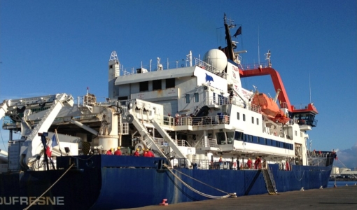 5 Mar 2021
Monitoring aerosol properties in the Indian Ocean
A ship-borne photometer of CIMEL CE318-T type was permanently installed in early January 2021 aboard the French research vessel Marion Dufresne in the frame of the MAP-IO (Marion Dufresne Atmospheric Program - Indian Ocean) research programme
News - Success Stories
 15 Mar 2021
1 km resolution aerosol optical thickness retrieved from PROBA-V
The ESA SPAR@MEP project aims to deliver a long-term data record (LTDR) of aerosol optical properties and surface reflectance from SPOT-VGT and PROBA-V observations.
News - Infographics
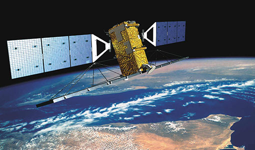
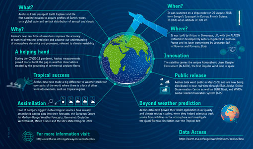 31 May 2021
Aeolus - ESA's mission dedicated to winds, aerosols and clouds
Learn more about ESA's youngest Earth Explorer - the Aeolus mission - in our latest infographic
News - Success Stories
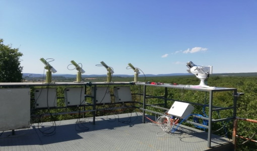
 15 Oct 2021
Askos campaign validates Aeolus data
From July to September 2021, the European Space Agency (ESA) organised the Joint Aeolus Tropical Atlantic Campaign (JATAC) in Cape Verde.
News - Success Stories
 13 Dec 2021
Ship trails in the Bay of Biscay observed using PROBA-V imagery
Ship trails have been perceived as convincing evidence of aerosol-cloud interaction. Ship emissions have been proven to contribute by about 1.9% and 2.9% to the increase in the global total and fine-mode aerosol optical thickness (AOT) respectively over a five year period (Peters et al. 20212).
News - Infographics
 16 Dec 2021
An overview of the very high-resolution Pleiades satellites
Find out about the achievements of the Pléiades programme in this infographic.
News - Success Stories
 17 Dec 2021
Pléiades celebrates 10 years and extends satellite fleet with Pléiades Neo
ESA is proud to mark the 10-year milestone of the Pléiades programme, a forerunner in providing very high resolution (VHR) commercial satellite imagery ideal for precision mapping and in-depth intelligence.
News - Data Release news
 13 Jan 2022
15 cm HD and 30 cm HD products added to EUSI ESA archive collections
Two new products, 15 cm HD and 30 cm HD, have been added to the collections from GeoEye-1, QuickBird-2, and WorldView (1 – 4).
News - Success Stories
 24 Jan 2022
Dust aerosol campaign validates Aeolus data
Prepared, implemented and executed by a consortium of French universities and research institutions, under the umbrella of the French Space Agency (CNES) and the French National Centre for Scientific Research (CNRS), the Clouds-Atmospheric Dynamics–Dust Interactions in West Africa (CADDIWA) campaign took place on Sal Island in Cape Verde, from 6 to 25 September 2021.
News - Thematic area articles
 2 Feb 2022
Satellite data boost global understanding of land surface
Understanding our changing land surface is essential in the study of climate change. Satellites are used to monitor changes to the material that covers Earth’s surface, so-called land cover, such as vegetation and water.