- All Categories (1005)
- Data (11)
- News (66)
- Missions (2)
- Events (16)
- Tools (5)
- Activities (4)
- Campaigns (10)
- Documents (891)
NEWS
Discover the latest news on the European Space Agency's Earth Observation activities. Learn all about new data availability and how ESA's missions are performing.
News - Data Release news
 16 May 2018
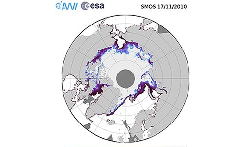
Eight years of SMOS Arctic sea ice thickness level now available from SMOS Data dissemination portal
Daily maps of sea ice thickness based on SMOS Observations, covering the winter seasons in the Arctic for the period of October-April from year 2010/2011 to year 2017/2018, are now available.
News - Success Stories
 14 May 2019
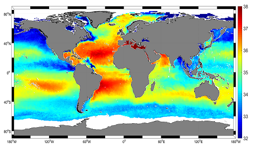
Mapping salty waters
The length and precision with which climate scientists can track the salinity, or saltiness, of the oceans is set to improve dramatically.
News - General News
 29 July 2019
Three new Third Party Missions under evaluation
ICEYE, PlanetScope and Spire under evaluation. Interested users can investigate suitability of the data for scientific and R&D activities.
News - Events and Proceedings
 21 Oct 2019
Special event for 10th anniversary of SMOS
Earth Explorers for Climate - The contribution from SMOS - an event to mark the 10th anniversary of SMOS mission.
News - Data Release news
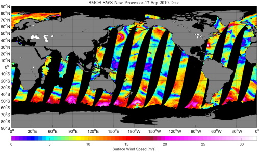
17 Apr 2020New SMOS sea surface wind speed products now available
The SMOS Wind Data Service provides, in near real time (NRT), surface wind speed over the ocean derived from the brightness temperature measurements of SMOS.
News - Success Stories
 22 Apr 2020
Earth Day: taking the pulse of our planet
While news of COVID-19 dominates headlines and many of us practice social distancing, there still remains the need for action on climate change - and satellites are vital in providing the key facts on this global issue.
News - Infographics
 30 Mar 2021
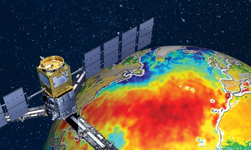
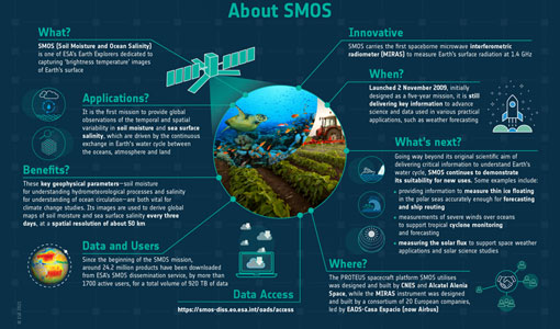
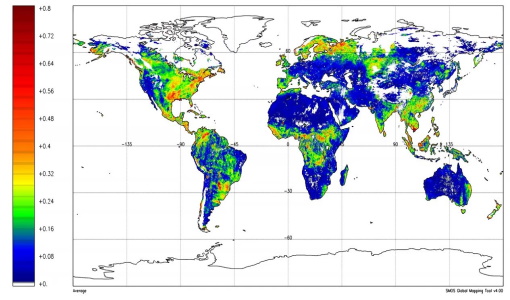
SMOS - ESA's soil moisture and ocean salinity mission
Learn more about the Soil Moisture and Ocean Salinity (SMOS) mission in our latest infographic.
News - Data Release news
 28 May 2021
SMOS level 1 and level 2 products new baseline is now available
New versions of the SMOS processors for level 1 and 2 were deployed in the operational ground segment on 25 May 2021.
News - Data Release news
 3 Aug 2021
New SMOS Level 1 Near Real Time processing baseline released
A new version of the SMOS level 1 Near Real Time processor - version 724 - was deployed in the operational ground segment on 2 August 2021.
News - Data Release news
 3 Aug 2021
New SMOS Level 2 Near Real Time Neural Network Soil Moisture baseline is released
A new version of the SMOS level 2 Near Real Time processor - version 300 - was deployed in the operational ground segment on 2 August 2021.
News - Data Release news
 4 Aug 2021
New SMOS Near Real Time Sea Surface Wind Speed new baseline is released
A new version of the SMOS Sea Surface Wind Speed processor - version 300 - was deployed at IFREMER and ESA operational ground segments on 4 August 2021.
News - Infographics
 8 Nov 2021
An overview of ESA's Third Party Missions programme
ESA’s Third Party Missions programme consists of almost 50 satellite missions, which are owned by organisations around the world. ESA has agreements with these organisations to acquire, process, and distribute data from their missions
News - Data Release news
18 Nov 2021SMOS sea ice thickness Arctic winter season 2021/2022 data available
SMOS Sea Ice thickness level 3 and level 4 data products are now available for the Arctic winter season 2021/2022.
News - General News
21 Dec 2021Updated SMOS documentation available
Updated versions of several SMOS data documents are now available.
News - Data Release news
 18 Jan 2022
SMOS sea ice thickness reprocessed data now available
The reprocessed SMOS level 3 and 4 sea ice thickness products over the Arctic are now available from the ESA SMOS Dissemination Service.
News - Thematic area articles
 2 Feb 2022
Satellite data boost global understanding of land surface
Understanding our changing land surface is essential in the study of climate change. Satellites are used to monitor changes to the material that covers Earth’s surface, so-called land cover, such as vegetation and water.
News - Data Release news
 24 Mar 2022
SMOS L2 Sea Surface Salinity products documentation updates
SMOS L2 Sea Surface Salinity product validation report is now available.
News - Thematic area articles
 31 Mar 2022
Satellite data central to ocean monitoring
Over 95% of Earth’s water is found in our oceans, and yet sadly, oceans are under stress from climate change and pollution. Monitoring our oceans is vital for Earth’s survival and satellites are the primary means of long-term and independent observation of our vast ocean bodies and their associated coastal zones.
News - Infographics
 20 Apr 2022
PlanetScope and SkySat - The high-resolution nanosatellite constellation
Find out more about the PlanetScope and SkySat missions in our new infographic.
News - Success Stories
 5 May 2022
Predicting crop yield using Planet data
The world’s population continues to grow, while the climate crisis is raising Earth’s temperatures and increasing the likelihood of extreme weather events – all of which affect food security.