- All Categories (112)
- Data (21)
- News (38)
- Missions (4)
- Events (6)
- Tools (9)
- Activities (1)
- Campaigns (14)
- Documents (19)
NEWS
Discover the latest news on the European Space Agency's Earth Observation activities. Learn all about new data availability and how ESA's missions are performing.
News - Success Stories
 23 June 2021
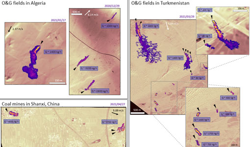
WorldView-3 satellite maps methane plumes at very high spatial resolution
Substantial advances have been made in the last years towards the detection and quantification of methane emissions from space- very high spatial resolution data from the WorldView-3 satellite can fill an important observational gap in the remote sensing of methane point emissions.
News - Success Stories
 6 July 2022
WorldView-3 helps to track offshore methane plumes from oil and gas
Scientists have used Earth observation data to reveal enormous methane plumes spilling out from an offshore oil and gas production rig in the Gulf of Mexico. This represents a significant breakthrough in the monitoring of industrial methane emissions from space.
News - Infographics
 2 Aug 2022
What are the next Earth Explorers?
Learn about the planned missions in the Earth Explorers programme - EarthCARE, Biomass, FLEX, and FORUM - which will further our understanding of Earth’s climate.
News - General News
 29 July 2019
Three new Third Party Missions under evaluation
ICEYE, PlanetScope and Spire under evaluation. Interested users can investigate suitability of the data for scientific and R&D activities.
News - Spotlight on EO community
7 May 2024Spotlight on Third Party Mission provider: EUSI
European Space Imaging (EUSI) is one of ESA’s suppliers of commercial Very High Resolution (VHR) satellite imagery for scientific research in Earth Observation (EO).
News - Thematic area articles
 21 July 2022
Space helps monitor Earth’s changing biosphere
Earth’s biosphere is continually changing. Through its pioneering Earth observation missions, ESA is making critical contributions to monitor these changes and their impacts on Earth’s water and carbon cycles.
News - Thematic area articles
30 Jan 2024Space data support Earth’s ecosystems
ESA’s Earth observation (EO) missions are making a critical contribution to monitoring transformations in our planet’s ecosystems, helping track changes in the vegetation, soil, and ocean that affect these systems.
News - Success Stories
30 Jan 2023Showcasing success stories from ESA's Third Party Missions
ESA’s Third Party Missions programme consists of more than 50 missions from around the world.
News - Thematic area articles
 16 Aug 2022
Satellites reveal changes to Earth’s icy zones
ESA’s Earth observation activities are helping scientists investigate the influence of climate change on widespread ice-losses across the planet.
News - Thematic area articles
 31 Mar 2022
Satellite data central to ocean monitoring
Over 95% of Earth’s water is found in our oceans, and yet sadly, oceans are under stress from climate change and pollution. Monitoring our oceans is vital for Earth’s survival and satellites are the primary means of long-term and independent observation of our vast ocean bodies and their associated coastal zones.
News - Thematic area articles
 2 Feb 2022
Satellite data boost global understanding of land surface
Understanding our changing land surface is essential in the study of climate change. Satellites are used to monitor changes to the material that covers Earth’s surface, so-called land cover, such as vegetation and water.
News - Data Release news
13 Feb 2024Sample data products from ESA’s Third Party Missions
Samples of data products from a range of Third Party Missions are now available to download, offering a preview of what these missions provide.
News - Success Stories
 4 Oct 2022
Remote sensing scientists raise alarm for African savannah
Researchers have used high resolution WorldView-3 imagery to map vegetation cover in the Greater Maasai Mara savannah, a global hotspot for biodiversity in Kenya.
News - Thematic area articles
23 Mar 2023Remote sensing data underpin research on soil
Environmental data disseminated by ESA’s Earth observation programmes provide knowledge about the stresses on Earth’s soils – aiding many applications such as crop management, drought and flood forecasting, and ecosystem protection.
News - Success Stories
24 Jan 2020RapidEye constellation retirement
After 11 years in operation, surpassing a design lifetime of 7 years, the RapidEye constellation will be retired in March 2020.
News - General News
8 Feb 2023Pioneering science missions: Summarising ESA’s Earth Explorers
Designed for research purposes, ESA's Earth Explorer missions are dedicated to monitoring parts of Earth’s system. Learn more about the Earth Explorers in this video.
News - Success Stories
 17 Mar 2022
New open-source Python library improves rapid mapping services
In emergency services, rapid response is paramount. ICube-SERTIT’s Rapid Mapping Service provides near real-time delivery of geo-information to help emergency services respond quickly to disasters such as flooding, fires and landslides. A new Python open-source library, called EOReader, speeds up this mapping response by enabling the easy opening of imagery from multiple satellite sensors, both optical and synthetic aperture radar (SAR).
News - Data Release news
31 Jan 2024New FLEX-related campaign datasets released
New datasets have been released for three campaigns, covering activities supporting the upcoming FLEX mission.
News - Data Release news
 15 Dec 2020
New Campaign datasets available
A new set of datasets is available, acquired during airborne campaigns conducted between 2014 and 2019
News - Spotlight on EO community
 18 Nov 2021
Meet a young researcher who combines remote sensing with deep learning techniques
Researcher MSc. Anupama Rajkumar recently investigated whether VHR satellite imagery could be combined with advanced deep learning techniques to automate the detection of waste landfills.