- All Categories (42)
- Data (5)
- News (27)
- Missions (1)
- Events (4)
- Activities (3)
- Campaigns (2)
NEWS
Discover the latest news on the European Space Agency's Earth Observation activities. Learn all about new data availability and how ESA's missions are performing.
News - Operational News
 7 Sept 2020
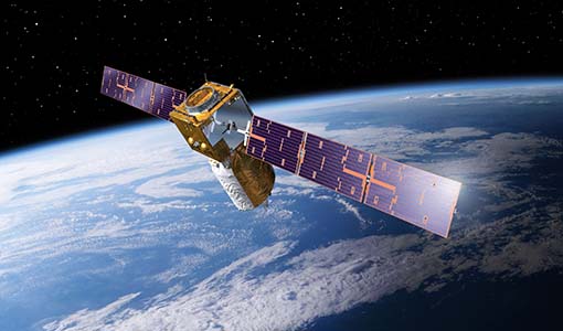
A Guide to Aeolus Range Bin Settings
After almost two years in space, Aeolus' near-real time observations have been assimilated into the Numerical Weather Prediction models of several European meteorological services, and have proven crucial during the COVID-19 pandemic, which led to a sharp decrease in meteorological observations.
News - Data Release news
 8 Mar 2023
Aeolus Level-2A old Baseline-11 data now publicly available
We are pleased to inform Aeolus users that 3232 Level 2A products in Baseline 11 that were not previously released are now available for browsing and download on the Aeolus Dissemination server.
News - Operational News
28 May 2020Aeolus set for Instrument Telescope Refocussing exercise
Aeolus's telescope requires periodic collimation and refocussing. To this end, the Instrument Telescope Refocussing activity aims to improve the radiometric performance of the Atmospheric Laser Doppler Instrument's telescope, ALADIN.
News - Infographics
 8 Nov 2021
An overview of ESA's Third Party Missions programme
ESA’s Third Party Missions programme consists of almost 50 satellite missions, which are owned by organisations around the world. ESA has agreements with these organisations to acquire, process, and distribute data from their missions
News - Spotlight on EO community
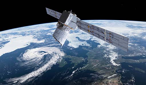
19 Apr 2023An overview of the Aeolus mission
In this overview video, ESA's mission manager, Tommaso Parrinello, describes the successes and challenges of this amazing mission, whose impacts will live long beyond its lifetime in space.
News - Success Stories
 26 May 2020
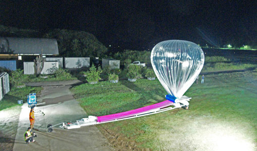
Around the world in eight balloons with Strateole-2
Strateole-2 is a French-US project supported by ESA that uses CNES superpressure balloons drifting around the globe to study the climate processes in the Tropical Tropopause Layer (TTL) and the lower stratosphere, helping Aeolus validation activities along the way.
News - Success Stories
 15 Oct 2021
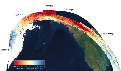
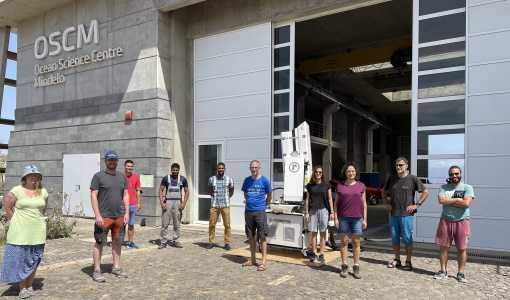
Askos campaign validates Aeolus data
From July to September 2021, the European Space Agency (ESA) organised the Joint Aeolus Tropical Atlantic Campaign (JATAC) in Cape Verde.
News - Events and Proceedings
9 Apr 2024Featuring the power of Earth observation data at EGU
The European Geosciences Union General Assembly 2024 brings together geoscientists from all over the world, aiming to provide a forum where scientists and early career researchers can present their work and discuss their ideas with experts, in all fields of geoscience.
News - Thematic area articles
7 Dec 2023How to use space data to probe humankind’s ancient past
Data disseminated by ESA’s Third Party Missions (TPM) programme are enabling archaeological investigations that could help to unravel the mysteries of past societies and cultures.
News - Data Release news
 20 Dec 2022
Improved Aeolus wind data now available
ESA’s Aeolus mission continues to advance weather forecasting with further data improvements, thanks to a third reprocessing campaign.
News - Spotlight on EO community
24 Mar 2023Introducing the Aeolus and CryoSat missions
In this video, Tommaso Parrinello - Mission Manager of Aeolus and CryoSat - describes what is involved in managing the missions and the unique challenges offered by such innovative satellites.
News - Operational News
 20 Apr 2023
New Aeolus Processing Baseline 16 now activated
The new Aeolus processing baseline 16 was activated on Tuesday 18 April 2023.
News - Success Stories
 17 Mar 2022
New open-source Python library improves rapid mapping services
In emergency services, rapid response is paramount. ICube-SERTIT’s Rapid Mapping Service provides near real-time delivery of geo-information to help emergency services respond quickly to disasters such as flooding, fires and landslides. A new Python open-source library, called EOReader, speeds up this mapping response by enabling the easy opening of imagery from multiple satellite sensors, both optical and synthetic aperture radar (SAR).
News - Infographics
24 Oct 2023Overview of Aeolus Level-2b scientific wind data
Learn more about the Aeolus Level-2b scientific wind product in our latest infographic.
News - Infographics
8 June 2023Overview of the Aeolus Level-1B wind product
Learn about the Aeolus Level-1B wind product, which supports applications for the weather, atmospheric processes and climate research, in our latest infographic.
News - Infographics
 20 Apr 2022
PlanetScope and SkySat - The high-resolution nanosatellite constellation
Find out more about the PlanetScope and SkySat missions in our new infographic.
News - Data Release news
 20 May 2022
PlanetScope and Skysat data available through ESA’s Third Party Missions Programme
Through ESA’s Third Party Missions Programme, researchers, scientists and companies from around the world can apply to access Planet’s high-frequency, high-resolution satellite data for non-commercial use.
News - Data Release news
 12 Aug 2019
PlanetScope and SkySat data now available
PlanetScope and SkySat missions under evaluation. Interested users can investigate suitability of the data for scientific and R&D activities.
News - Success Stories
 5 May 2022
Predicting crop yield using Planet data
The world’s population continues to grow, while the climate crisis is raising Earth’s temperatures and increasing the likelihood of extreme weather events – all of which affect food security.
News - Thematic area articles
25 Apr 2023Remote sensing data map impacts of natural hazards
As climate change increases the frequency and severity of natural disasters, remote sensing data can warn about extreme events and help tackle emergency situations.