- All Categories (55309)
- Data (73)
- News (197)
- Missions (3)
- Events (66)
- Tools (33)
- Activities (15)
- Campaigns (26)
- Documents (54896)
NEWS
Discover the latest news on the European Space Agency's Earth Observation activities. Learn all about new data availability and how ESA's missions are performing.
News - Infographics
 5 Oct 2022
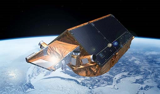
What is CRYO2ICE?
Learn about CRYO2ICE, an innovative campaign producing near simultaneous acquisitions over Antarctica from the CryoSat and ICESAT-2 missions, in this new infographic.
News - Success Stories
 22 Dec 2020
Using Satellite Data to Predict Floods and Droughts
Scientists are turning to remote sensing to fill the in-situ data gap in hydrological data models in some parts of the world.
News - Data Release news
 12 July 2019
Updated Precise Orbit data (POD) for the full ERS-1 and ERS-2 mission available
The Precise Orbit files (ERS.ORB.POD) for the entire ERS-1 and ERS-2 mission periods have been reprocessed with up-to-date standards.
News - Data Release news
 13 May 2022
Updated CryoSat magnetometer data now available with new baseline 0201
An improved version of the CryoSat magnetic field data is now available on the Swarm Dissemination Server with new baseline 0201.
News - Data Release news
 5 Dec 2019
Updated CryoSat magnetometer data now available
An improved version of the CryoSat magnetic field data (version 0102) is now available in the "#CryoSat-2" folder of the ESA FTP server.
News - Data Release news
 30 Apr 2020
Updated CryoSat magnetometer data now available
An improved version of the CryoSat magnetic field data (version 0103) is now available.
News - Infographics
22 Feb 2023Twin satellites - TerraSAR-X and TanDEM-X
DLR's TerraSAR-X and TanDEM-X are twin satellites flying in close formation to acquire SAR data of unique geometric accuracy. Operating together, the missions deliver data that are used to generate Digital Elevation Models of Earth.
News - Thematic area articles
 30 June 2022
Transforming space data into climate action
ESA’s Earth observation activities are playing a key role in the revitalised global drive to combat climate change.
News - Success Stories
7 Feb 2024Trailblazing ERS-2 mission enables climate change applications
As ESA’s ERS-2 satellite approaches Earth’s atmosphere for reentry, it’s time to reflect on the mission’s great achievements in powering climate-related applications.
News - Thematic area articles
29 Aug 2023Tracking the world’s forests from space
As human activities continue to threaten the planet’s forests, data delivered by satellites are boosting global efforts to conserve these crucial natural resources.
News - Success Stories
 25 Aug 2022
Tracking mountainous glaciers using TanDEM-X
Ice melting from mountain glaciers is one of the largest contributors to sea-level rise outside the large ice sheets of Antarctica and Greenland. New research leveraging the vast data from the TanDEM-X mission, has successfully mapped glacial elevation change over multiple mountainous regions of the world.
News - Infographics
 28 Jan 2022
Timeline to over 40 years of historical satellite missions
ESA's Heritage Space Programme preserves historical data from over 40 years of Earth observation missions.
News - Success Stories
 2 July 2020
The Earthnet Programme: 40 years of evolution and future challenges
ESA's Earthnet Programme provided the initial means to access and exploit Earth Observation data.
News - Data Release news
 7 Dec 2021
TerraSAR-X/TanDEM-X WorldDEM data now available to users
WorldDEM products have been added to the TerraSAR-X/TanDEM-X offering and are now available to users for research and application development following submission of a project proposal subject to evaluation and acceptance by ESA and the data owner.
News - Data Release news
6 June 2019TerraSAR-X ESA archive dataset now available
TerraSAR-X and TanDEM-X products are available to the scientific community.
News - Operational News
 12 Feb 2024
Temporary interruption to Envisat AATSR dissemination service
A planned downtime will affect the access to the ftp dissemination server for the Envisat AATSR data during the period 13-15 February 2024.
News - Data Release news
 7 May 2020
Systematic swath elevation and monthly DEMs over the Greenland Ice Sheet margin from CryoSat
The CryoTEMPO-EOLIS (Elevation Over Land Ice from Swath), the first of the CryoTEMPO products, is now available.
News - Data Release news
 20 Oct 2020
Systematic swath elevation and monthly DEMs over the Antarctica Ice Sheet margin from CryoSat 2
Land-ice is declining globally, raising sea levels worldwide and impacting glacial risks and access to fresh-water in high-mountain glaciers regions.
News - General News
23 Feb 2023Stunning new features for ESA and NASA altimetry portal cs2eo.org
Working with combined ESA and NASA altimetry data is easier than ever thanks to a range of handy new features on cs2eo.org.
News - Success Stories
 11 Sept 2018
Special CryoSat issue in Advances in Space Research journal
A special issue of the Advances in Space Research journal dedicated to CryoSat is available to download.