- Learn & Discover
- Tracking mountainous glaciers ...
Tracking mountainous glaciers using TanDEM-X
25 Aug 2022
Sudden collapse of glaciers, such as the tragedy in the Marmolada glacier in the Italian Dolomites this summer, highlight the importance of keeping a watchful eye on glacial melt.
Ice melting from mountain glaciers is one of the largest contributors to sea-level rise outside the large ice sheets of Antarctica and Greenland. As well as this detrimental trend, the loss of glacier ice jeopardises irrigation, hydro power, tourism and drinking water.
New research leveraging the vast data from the TanDEM-X mission, has successfully mapped glacial elevation change over multiple mountainous regions of the world.
Monitoring mountain glaciers is hampered by their considerable number and remote locations. Researchers based in the Friedrich-Alexander Universität (FAU), in Germany, recently derived surface elevation change rates for mountainous glaciers using interferometric synthetic aperture radar (InSAR) from bistatic X-band TanDEM-X data.
The project is called SATELLITE (A stochastic eStimATe of sEa Level contribution from gLaciers and Ice caps using satellite remoTe sEnsing) and recent results were presented at the Living Planet Symposium in Bonn.
Complementary to ESA Earth observation missions, ESA’s Third Party mission (TPM) programme allows researchers free access to a large portfolio of commercial and non-ESA remote sensing data for scientific purposes.
Germany’s TanDEM-X mission is one such third party mission. It is based on two almost identical satellites, TerraSAR-X and TanDEM-X from DLR (the German Aerospace Centre), which are equipped with powerful Synthetic Aperture Radar (SAR) systems. The mission started with TerraSAR-X in 2007 and was enhanced with the TanDEM-X add-on for Digital Elevation Measurement (DEM).
Two satellites generate 3D maps
Just as our slightly separated eyes produce two different 2D images, which are interpreted as depth – or 3D - in our brain, the two TanDEM-X satellites are capable of generating a 3D elevation model of the entire Earth surface.
Researcher Christian Sommer, from the project, explains, “We took the raw radar data from TanDEM-X, with a resolution of about 10 metres, and then performed radar interferometry to produce digital elevation models.
“By comparing such models over multiple years, we could then produce a time series to show how mountainous glaciers are evolving over time.”
InSAR approach targets individual glaciers
As also shown by other studies based on satellite altimetry and gravimetry instruments, this research team showed that mountain glaciers are melting due to global climate change.
Significantly, this research also demonstrated there has been an acceleration in this melting since 2010. However, the novel aspect of this InSAR approach using bistatic TanDEM-X, is that it can target individual glaciers.
“Our dataset provides a spatial coverage of almost 90%, which is higher than previous mountain glacier assessments,” says Sommer.
According to Sommer, there are only two satellite missions capable of providing this spatially complete global elevation change maps, namely the optical satellite ASTER (Advanced Spaceborne Thermal Emission and Reflection Radiometer) from the Japanese Space Agency, and TanDEM-X.
“TanDEM-X provides a good resolution - the time difference between the acquisitions of the two satellites is so small that the interferometric method allows us to create very accurate elevation models based on this data,” adds Sommer.
TanDEM-X launched in 2010. The research estimated changes in glacier volume and mass over the last two decades by using X-band TanDEM-X data from 2010-2020, but also using C-band data measurements from the international Shuttle Radar Topography Mission (STRM) from 2000 to 2010.
Tracking glacial melt in Southern Hemisphere
The largest ice-covered areas of the Southern Hemisphere are located in Antarctica, Patagonia, and across the surrounding islands of Antarctica. While the melting of glaciers in South America and the Antarctic Islands are considered strong contributors to global sea level rise, there is limited knowledge of glacier mass balance in these regions.
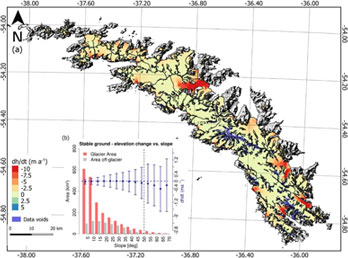
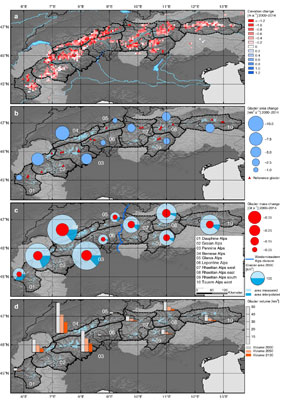
The German research team have already derived results for the South American Andes, South Georgia [1], the European Alps [2] and the Russian Arctic.
South Georgia is the largest sub-Antarctic island and about 63% of its surface is covered by glaciers. Overall, the research showed negative mass balance rates in South Georgia, with the highest thinning and retreat rates at the large outlet glaciers located at the north-east coast.
With the help of high performance computing at the Friedrich-Alexander Universität, the team will soon publish results with global digital elevation maps for all glacierised regions outside the Antarctic and Greenland Ice Sheets.
Through ESA’s TPM programme, TanDEM-X mission data are available to a range of stakeholders, such as researchers, businesses, regulators and governments.
Find out more about the TanDEM-X and TerraSAR-X archive and data.