- All Categories (74)
- Data (16)
- News (18)
- Missions (2)
- Events (19)
- Tools (2)
- Activities (2)
- Documents (15)
NEWS
Discover the latest news on the European Space Agency's Earth Observation activities. Learn all about new data availability and how ESA's missions are performing.
News - Thematic area articles
7 Dec 2023How to use space data to probe humankind’s ancient past
Data disseminated by ESA’s Third Party Missions (TPM) programme are enabling archaeological investigations that could help to unravel the mysteries of past societies and cultures.
News - Success Stories
31 Aug 2023New CryoSat data to boost understanding of the oceans
A new CryoSat sea level anomaly product designed to enable ocean science and the development of operational marine applications has been released.
News - Thematic area articles
25 May 2023How satellite data empower sustainable urban growth
Earth observation is a vital tool for facilitating the sustainable development of the world's cities, helping to ensure that urban centres keep spurring collaboration, innovation and opportunity as they continue to expand.
News - Thematic area articles
3 Mar 2023Monitoring water on Earth's surface
ESA's Earth observation satellites are playing a leading role in furthering our understanding of how Earth's terrestrial hydrosphere is being influenced by humankind.
News - Thematic area articles
9 Dec 2022Global understanding of Earth's land surfaces greatly boosted by satellite data
ESA perform land surface monitoring with a range of instruments onboard satellites acquiring optical and radar data. Collections of data from these missions are freely available for research purposes.
News - Success Stories
 17 Nov 2022
New worldwide dataset captures the planet in fine detail
Scientists have developed an open source planetwide dataset of high-resolution Earth observation imagery, thanks to commercial data delivered by ESA’s Third Party Missions (TPM) programme.
News - Thematic area articles
 29 Sept 2022
How satellite data help to shape society
Data from ESA’s Earth observation archives are improving understanding of the interactions between human activities and the environment, helping to power green economic development and boosting prosperity in Europe and beyond.
News - Data Release news
 28 July 2022
Spot Extended Area mode added to ICEYE on-demand portfolio
As an evolution of Spot mode, Spot Extended Area products are now available with the same resolution of Spot data (ground resolution of 1 m) but enabling to cover the area of 225 km2 (15 x 15 km) in a single SAR image.
News - Infographics
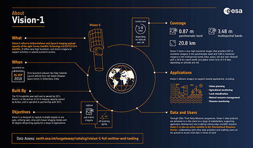 14 June 2022
An overview of the very high-resolution Vision-1 satellite
Learn about Vision-1, which joined ESA's Third Party Missions programme in May, in our new infographic.
News - Infographics
 20 Apr 2022
PlanetScope and SkySat - The high-resolution nanosatellite constellation
Find out more about the PlanetScope and SkySat missions in our new infographic.
News - Success Stories
 9 Mar 2022
10 years of Envisat data help to illuminate ocean processes
A decade after Envisat beamed its final image to the planet, the pioneering ESA mission is continuing to foster improved understanding of Earth’s systems.
News - Infographics
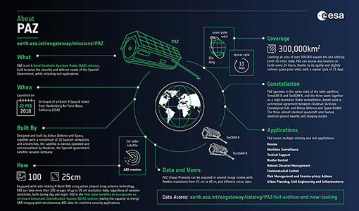 15 Feb 2022
An overview of the PAZ SAR satellite mission
Learn more about the PAZ mission, a Spanish X-Band SAR satellite and part of ESA's Third Party Missions programme, in our latest infographic.
News - Thematic area articles
 2 Feb 2022
Satellite data boost global understanding of land surface
Understanding our changing land surface is essential in the study of climate change. Satellites are used to monitor changes to the material that covers Earth’s surface, so-called land cover, such as vegetation and water.
News - Data Release news
 17 June 2021
ESA's (A)SAR dissemination service enhanced with Envisat ASAR MR L1 data
With integration of four additional Envisat ASAR Level 1 collections, ESA is now providing access to the complete Envisat and ERS (A)SAR imagery data archive via the ESA (A)SAR Online Dissemination service.
News - Success Stories
 22 Dec 2020
Using Satellite Data to Predict Floods and Droughts
Scientists are turning to remote sensing to fill the in-situ data gap in hydrological data models in some parts of the world.
News - General News
 18 June 2020
ICEYE data available for assessment
The SAR user community is invited to participate to the call to assess the suitability of the ICEYE constellation, for science and EO-based applications.
News - Success Stories
 6 Mar 2020
Heritage data still widely used today
For about 30 years now, ESA satellites have been cruising some 800 km above our heads, collecting information about our planet-but why are older missions still so fundamental today?
News - Data Release news
 20 June 2018
New ERS-2 GOME Level 1 v5.1 dataset available online
A new GOME Level 1b dataset has been generated for the 16-year mission period bringing relevant quality improvements for the revised calibration approach, compensating aging and instrument degradation, and provide enhanced accessibility.