- All Categories (23460)
- Data (22)
- News (91)
- Missions (2)
- Events (22)
- Tools (8)
- Activities (8)
- Campaigns (22)
- Documents (23285)
Document - Technical Note

(A)ATSR Expert Support Laboratory FAST Level 1b Product Definition
(A)ATSR Expert Support Laboratory FAST Level 1b Product Definition.pdf
Document - Conference Presentation - Poster

04_OCT2013_ESA-EO_programmes.pdf
ESA EO missions and their exploitation for science and applications ESA
News - Data Release news

2015 CryoSat Ice Baseline D reprocessed data now available
The reprocessed CryoSat Ice Baseline D data for all of 2015 has now been published on the Science Server.
News - Data Release news

2016 CryoSat Ice Baseline D reprocessed data now available
The reprocessed CryoSat Ice Baseline D data for 2016 has now been published on the Science Server.
Event - Training

2nd Advanced Training Course on Ocean Remote Sensing 2009
This advanced training course focused on ocean remote sensing theory and applications.
Event - Workshop

2nd Space for Hydrology Workshop
The workshop aimed to assess the current stage of knowledge and activities in space-based hydrological observations and to exchange knowledge and know how with hydrologists and researchers.
Document - Technical Note

34th AATSR QWG Meeting Summary
The 34th AATSR QWG Meeting was held on 28th/29th March 2017 at RAL, Harwell, U.K. ThisMemorandum states the objectives of the Meeting, gives a selected highlight, and summarisesthe discussions that took place.
Event - Conference

3rd ERS Symposium
The ESA Directorate for Observation of the Earth and its Environment held the 3rd ERS Symposium, in 1997, where many of the results from the ERS-1 and ERS-2 missions were presented and discussed by the scientific community.
News - Operational News
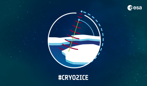
A Closer Look at CRYO2ICE Manoeuvres
Between 16 and 31 July 2020, ESA raised the orbit of Earth Explorer CryoSat-2 to periodically align with NASA’s ICESat-2 in a campaign dubbed CRYO2ICE.
News - Success Stories
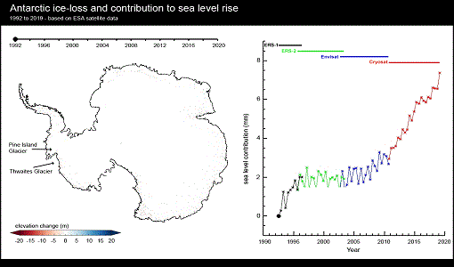
A quarter of glacier ice in West Antarctica is now unstable
Scientists have discovered warming ocean waters have caused ice to thin so rapidly that 24% of glacier ice in West Antarctica is now affected.
News - Infographics
About cs2eo.org – Accessing combined ESA and NASA altimetry data
cs2eo.org is a free, easy-to-use portal that make it easier and quicker than ever to work with combined CryoSat and ICESat altimetry data.
Event - Training
Advanced Training Course in Ocean Remote Sensing 2011
Within the framework of the Dragon Programme, a joint collaboration between the European Space Agency (ESA) and the Chinese Ministry of Science and Technology (MOST), ESA and NRSCC are providing a series of advanced thematic training courses on remote sensing applications hosted by university and research institutions in P.R. China.
News - Operational News

Announcement for CryoSat Quaternions Product users
CryoSat users who use the Quaternions Products should be aware that the method to access these products is changing.
Document - General Reference

Application-of-satellite-remote-sensing-to-developing-countries.pdf
This booklet is a preliminary copy of the first set of viewgraphs being prepared by Satellite Observing Systems (SOS) for ESA to support Agencies activities for promoting the use of Earth observation data from space in various environmental disciplines and applications for developing countries.
Event - Workshop
Applications of the ERS Along Track Scanning Radiometer Workshop 1999
The workshop on ERS mission's Along Track Scanning Radiometer (ATSR) instrument gathered researchers and specialists working on different applications of the mission.
Campaign

BACCHUS-DOC
The BACCHUS-DOC Radar and Optical Campaign was an area mapping project of vineyards near Frascati (Italy). ESA required high resolution geo-referenced airborne SAR data of different wavelength and polarisation (preferably polarimetric).
Data - Campaigns (Open)
BACCHUS-DOC
The BACCHUS-DOC Radar and Optical Campaign was an area mapping project of vineyards near Frascati (Italy). ESA required high resolution geo-referenced airborne SAR data of different wavelength and polarisation (preferably polarimetric).
News - Data Release news

Back-processed data from 2010 now available for CryoTEMPO-EOLIS Baseline 2
Following on from the release of new Baseline 2 point and gridded products for CryoTEMPO-EOLIS, the data for several regions have now been back-processed to 2010 and are available from the CryoSat Science Server.
News - Data Release news
Brand new Cryo-TEMPO Baseline-B boosts CryoSat research
New datasets have been released for the Cryo-TEMPO thematic products.
Event - Workshop
CEOS-IVOS Workshop on Inter-comparison of Large Scale Optical and Infrared Sensors
The 2004 workshop was an opportunity to present and exchange experiences and knowledge from work on inter-comparing large scale optical sensors at different product levels.