- All Categories (74)
- Data (10)
- News (37)
- Missions (6)
- Events (1)
- Tools (6)
- Documents (14)
Document - Product Document

Urban-Atlas-Data-Coverage-WorldView-2.pdf
14EUSI-1961 Urban Atlas Data Coverage with WorldView-2 Data
Document - User Guide

ResourceSat-1-Data-User-Handbook.pdf
The IRS-P6 Data User’s Handbook is published to provide essential information to the users about the mission - the sensors, orbit and coverage, referencing scheme, data acquisition, products, services and potential applications of the data.
Document - Conference Presentation - Poster

8-Ship-Detection-High-Res-Satellite-Imagery.pdf
Ship Detection using High Resolution Satellite Imagery and Space-Based AIS Tonje Nanette Hannevik (FFI, Norway)
Mission - Third Party Missions

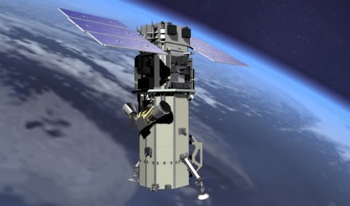
WorldView-2
WorldView-2 is an environment-monitoring satellite from Maxar which presents images as the human eye can perceive them, creating a more realistic 'true colour' view of the world.
Mission - Third Party Missions
WorldView-3
WorldView-3 is the first multi-payload, super-spectral, high-resolution commercial satellite sensor operating at an altitude of 617 km. WorldView-3 is capable of collecting up to 680,000 square km per day.
Tools - Analysis

SNAP
SNAP is a common architecture for all Sentinel Toolboxes. It is ideal for Earth observation processing and analysis.
Mission - Heritage Missions
IRS-P6 (ResourceSat-1)
IRS-P6 (also known as ResourceSat-1) launched on 17 October 2003 from Satish Dhawan Space Centre by the Indian PSLV-C5, and came to an end on 30 September 2013.
Mission - Third Party Missions

WorldView Series
The WorldView constellation are environment-monitoring satellites that have been supplying imagery since 2007.
Tools - Analysis

Sentinel-2 Toolbox
The Toolbox consists of a rich set of visualisation, analysis and processing tools for the exploitation of optical high-resolution products including the Sentinel-2 MSI sensor.
Mission - Third Party Missions

WorldView-1
WorldView-1 helped meet the growing commercial demand for multi-spectral geospatial imagery.
Data - Fast Registration with approval (Restrained)
Image 2006 European coverage
The Image 2006 collection is a SPOT-4, SPOT-5 and ResourceSat-1 (also known as IRS-P6) cloud free coverage over 38 European countries in 2006 (from February 2005 to November 2007). The Level 1 data provided in this collection originate from the SPOT-4 HRVIR instrument (with 20 m spatial resolution), from SPOT-5 HRG (with 10 m spatial resolution resampled to 20 m) and IRS-P6 LISS III (with 23 m spatial resolution), each with four spectral bands. The swath is of about 60 km for the SPOT satellites and 140 km for the IRS-P6 satellite. In addition to the Level 1, the collection provides the same data geometrically corrected towards a European Map Projection with 25 m resolution. Spatial coverage: Check the spatial coverage of the collection on a map available on the Third Party Missions Dissemination Service.
Data - Project Proposal (Restrained)
ResourceSat-1/IRS-P6 full archive
ResourceSat-1 (also known as IRS-P6) archive products are available as below: Sensor Type Resolution (m) Coverage (km x km) System or radiometrically corrected Ortho corrected (DN) Neustralitz archive Global archive LISS-IV Mono-Chromatic 5 70 x 70 X X 2004 – 2010 2003 - 2013 LISS-III Multi-spectral 20 140 x 140 X X 2004 – 2013 2003 - 2013 AWiFS Multi-spectral 60 370 x 370 X X 2004 – 2013 2003 - 2013 Note: LISS-IV: Mono-Chromatic, the band is selectable. In practice the red is used. For LISS-IV MN and LISS-III ortho corrected: If unavailable, user has to supply ground control information and DEM in suitable quality. For AWiFS ortho corrected: service based on in house available ground control information and DEM. The products are available as part of the GAF Imagery products from the Indian missions: IRS-1C, IRS-1D, CartoSat-1 (IRS-P5), ResourceSat-1 (IRS-P6) and ResourceSat-2 (IRS-R2) missions. 'ResourceSat-1 archive' collection has worldwide coverage: for data acquired over Neustrelitz footprint, the users can browse the EOWEB GeoPortal catalogue to search archived products; worldwide data (out the Neustrelitz footprint) can be requested by contacting GAF user support to check the readiness since no catalogue is not available. All details about the data provision, data access conditions and quota assignment procedure are described in the Terms of Applicability.
Data - Project Proposal (Restrained)

WorldView-3 full archive and tasking
WorldView-3 high resolution optical products are available as part of the Maxar Standard Satellite Imagery products from the QuickBird, WorldView-1/-2/-3/-4, and GeoEye-1 satellites. All details about the data provision, data access conditions and quota assignment procedure are described into the Terms of Applicability available in Resources section. In particular, WorldView-3 offers archive and tasking panchromatic products up to 0.31m GSD resolution, 4-Bands/8-Bands products up to 1.24 m GSD resolution, and SWIR products up to 3.70 m GSD resolution. Band Combination Data Processing Level Resolution High Res Optical: Panchromatic and 4-bands Standard(2A)/View Ready Standard (OR2A) 15 cm HD, 30 cm HD, 30 cm, 40 cm, 50/60 cm View Ready Stereo 30 cm, 40 cm, 50/60 cm Map Ready (Ortho) 1:12.000 Orthorectified 15 cm HD, 30 cm HD, 30 cm, 40 cm, 50/60 cm High Res Optical: 8-bands Standard(2A)/View Ready Standard (OR2A) 30 cm, 40 cm, 50/60 cm View Ready Stereo 30 cm, 40 cm, 50/60 cm Map Ready (Ortho) 1:12.000 Orthorectified 30 cm, 40 cm, 50/60 cm High Res Optical: SWIR Standard(2A)/View Ready Standard (OR2A) 3.7 m or 7.5 m (depending on the collection date) Map Ready (Ortho) 1:12.000 Orthorectified 4-Bands being an optional from: 4-Band Multispectral (BLUE, GREEN, RED, NIR1) 4-Band Pan-sharpened (BLUE, GREEN, RED, NIR1) 4-Band Bundle (PAN, BLUE, GREEN, RED, NIR1) 3-Bands Natural Colour (pan-sharpened BLUE, GREEN, RED) 3-Band Colored Infrared (pan-sharpened GREEN, RED, NIR1) 8-Bands being an optional from: 8-Band Multispectral (COASTAL, BLUE, GREEN, YELLOW, RED, RED EDGE, NIR1, NIR2) 8-Band Bundle (PAN, COASTAL, BLUE, GREEN, YELLOW, RED, RED EDGE, NIR1, NIR2) Native 30 cm and 50/60 cm resolution products are processed with MAXAR HD Technology to generate respectively the 15 cm HD and 30 cm HD products: the initial special resolution (GSD) is unchanged but the HD technique increases the number of pixels and improves the visual clarity achieving aesthetically refined imagery with precise edges and well reconstructed details. As per ESA policy, very high-resolution imagery of conflict areas cannot be provided.
Data - Project Proposal (Restrained)

WorldView-2 European Cities
ESA, in collaboration with European Space Imaging, has collected this WorldView-2 dataset covering the most populated areas in Europe at 40 cm resolution. The products have been acquired between July 2010 and July 2015. Spatial coverage: Check the spatial coverage of the collection on a map available on the Third Party Missions Dissemination Service.
Data - Project Proposal (Restrained)
WorldView-2 full archive and tasking
WorldView-2 high resolution optical products are available as part of the Maxar Standard Satellite Imagery products from the QuickBird, WorldView-1/-2/-3/-4, and GeoEye-1 satellites. All details about the data provision, data access conditions and quota assignment procedure are described into the Terms of Applicability available in Resources section. In particular, WorldView-2 offers archive and tasking panchromatic products up to 0.46 m GSD resolution, and 4-Bands/8-Bands Multispectral products up to 1.84 m GSD resolution. Band Combination Data Processing Level Resolution Panchromatic and 4-bands Standard (2A)/View Ready Standard (OR2A) 15 cm HD, 30 cm HD, 30 cm, 40 cm, 50/60 cm View Ready Stereo 30 cm, 40 cm, 50/60 cm Map-Ready (Ortho) 1:12.000 Orthorectified 15 cm HD, 30 cm HD, 30 cm, 40 cm, 50/60 cm 8-bands Standard(2A)/View Ready Standard (OR2A) 30 cm, 40 cm, 50/60 cm View Ready Stereo 30 cm, 40 cm, 50/60 cm Map-Ready (Ortho) 1:12.000 Orthorectified 30 cm, 40 cm, 50/60 cm 4-Bands being an optional from: 4-Band Multispectral (BLUE, GREEN, RED, NIR1) 4-Band Pan-sharpened (BLUE, GREEN, RED, NIR1) 4-Band Bundle (PAN, BLUE, GREEN, RED, NIR1) 3-Bands Natural Colour (pan-sharpened BLUE, GREEN, RED) 3-Band Colored Infrared (pan-sharpened GREEN, RED, NIR1). 8-Bands being an optional from: 8-Band Multispectral (COASTAL, BLUE, GREEN, YELLOW, RED, RED EDGE, NIR1, NIR2) 8-Band Bundle (PAN, COASTAL, BLUE, GREEN, YELLOW, RED, RED EDGE, NIR1, NIR2). Native 30 cm and 50/60 cm resolution products are processed with MAXAR HD Technology to generate respectively the 15 cm HD and 30 cm HD products: the initial special resolution (GSD) is unchanged but the HD technique increases the number of pixels, improves the visual clarity and allows to obtain an aesthetically refined imagery with precise edges and well reconstructed details. As per ESA policy, very high-resolution imagery of conflict areas cannot be provided.
Data - Fast Registration with approval (Restrained)
WorldView-1 full archive and tasking
WorldView-1 high resolution optical products are available as part of the Maxar Standard Satellite Imagery products from the QuickBird, WorldView-1/-2/-3/-4, and GeoEye-1 satellites. All details about the data provision, data access conditions and quota assignment procedure are described into the Terms of Applicability available in Resources section. In particular, WorldView-1 offers archive and tasking panchromatic products up to 0.50 m GSD resolution. Band Combination Data Processing Level Resolution Panchromatic Standard(2A)/View Ready STANDARD (OR2A) 50 cm, 30 cm HD View Ready Stereo 50 cm Map-Ready (Ortho) 1:12.000 Orthorectified 50 cm, 30 cm HD Native 50 cm resolution products are processed with MAXAR HD Technology to generate the 30 cm HD products: the initial special resolution (GSD) is unchanged but the HD technique increases the number of pixels and improves the visual clarity achieving aesthetically refined imagery with precise edges and well reconstructed details. As per ESA policy, very high-resolution imagery of conflict areas cannot be provided.
Tools - Visualisation
EVDC Orbit Prediction Tool
The EVDC Orbit Prediction and Overpass Tool generates and visualises satellite's overpasses.
News - Data Release news
ESA TPM collection ‘Worldview-2 European Cities’ expanded
The WorldView-2 European Cities ESA dataset has been enriched with 3,149 additional products.
Document - User Guide
TPM-L-OADS-dissemination-service-User-Manual.pdf
This guide describes the Third Party Missions Dissemination System.
News - General News

ESA’s Earth Observation Catalogue and its services
EO-CAT is the EO Catalogue tool allowing users to search ESA and Third Party Mission collections.