- All Categories (81)
- Data (11)
- News (25)
- Missions (2)
- Events (13)
- Tools (6)
- Activities (2)
- Campaigns (11)
- Documents (11)
News - Infographics
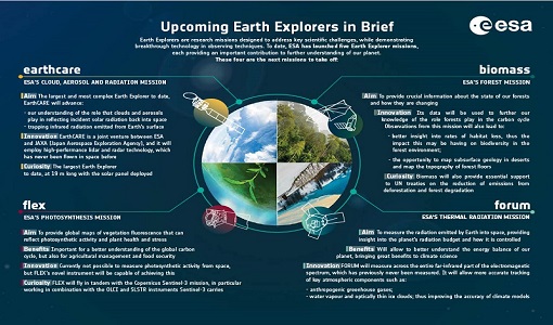
What are the next Earth Explorers?
Learn about the planned missions in the Earth Explorers programme - EarthCARE, Biomass, FLEX, and FORUM - which will further our understanding of Earth’s climate.
Event - Meeting
VH-RODA and CEOS SAR workshop
The workshop provided an open forum for the presentation and discussion of current status and future developments related to the calibration and validation of space borne very high-resolution SAR and optical sensors and data products.
Campaign
TropiScat
The major objectives of the experiment were the temporal survey of the variation of the measurements in time scales ranging from diurnal, weekly, monthly, up to 12 months of observation.
Campaign
TropiSAR 2009
The TropiSAR campaign objectives were the evaluation of P-Band radar imaging over tropical forests for biomass and forest height estimation.
News - Thematic area articles
Tracking the world’s forests from space
As human activities continue to threaten the planet’s forests, data delivered by satellites are boosting global efforts to conserve these crucial natural resources.
News - Infographics
Timeline to over 40 years of historical satellite missions
ESA's Heritage Space Programme preserves historical data from over 40 years of Earth observation missions.
News - Success Stories
Studying forest biomass from space
Forestry expert Maurizio Santoro, senior researcher at Gamma Remote Sensing and one of the leaders of ESA projects related to the Climate Change Initiative (CCI), explains how the use of various data.
News - Thematic area articles
Space helps monitor Earth’s changing biosphere
Earth’s biosphere is continually changing. Through its pioneering Earth observation missions, ESA is making critical contributions to monitor these changes and their impacts on Earth’s water and carbon cycles.
News - Thematic area articles
Space data support Earth’s ecosystems
ESA’s Earth observation (EO) missions are making a critical contribution to monitoring transformations in our planet’s ecosystems, helping track changes in the vegetation, soil, and ocean that affect these systems.
Event - Workshop
Space and the Arctic 2009 Workshop
Temperatures in the Arctic are rising at an unprecedented rate. This workshop looked at the needs and challenges of working and living in the rapidly changing Arctic and explore how space-based services might help to meet those needs.
News - Thematic area articles
Satellite data central to ocean monitoring
Over 95% of Earth’s water is found in our oceans, and yet sadly, oceans are under stress from climate change and pollution. Monitoring our oceans is vital for Earth’s survival and satellites are the primary means of long-term and independent observation of our vast ocean bodies and their associated coastal zones.
News - Data Release news
Sample data products from ESA’s Third Party Missions
Samples of data products from a range of Third Party Missions are now available to download, offering a preview of what these missions provide.
Data - Project Proposal (Restrained)
ResourceSat-1/IRS-P6 full archive
ResourceSat-1 (also known as IRS-P6) archive products are available as below: Sensor Type Resolution (m) Coverage (km x km) System or radiometrically corrected Ortho corrected (DN) Neustralitz archive Global archive LISS-IV Mono-Chromatic 5 70 x 70 X X 2004 – 2010 2003 - 2013 LISS-III Multi-spectral 20 140 x 140 X X 2004 – 2013 2003 - 2013 AWiFS Multi-spectral 60 370 x 370 X X 2004 – 2013 2003 - 2013 Note: LISS-IV: Mono-Chromatic, the band is selectable. In practice the red is used. For LISS-IV MN and LISS-III ortho corrected: If unavailable, user has to supply ground control information and DEM in suitable quality. For AWiFS ortho corrected: service based on in house available ground control information and DEM. The products are available as part of the GAF Imagery products from the Indian missions: IRS-1C, IRS-1D, CartoSat-1 (IRS-P5), ResourceSat-1 (IRS-P6) and ResourceSat-2 (IRS-R2) missions. 'ResourceSat-1 archive' collection has worldwide coverage: for data acquired over Neustrelitz footprint, the users can browse the EOWEB GeoPortal catalogue to search archived products; worldwide data (out the Neustrelitz footprint) can be requested by contacting GAF user support to check the readiness since no catalogue is not available. All details about the data provision, data access conditions and quota assignment procedure are described in the Terms of Applicability.
Document - User Guide
ResourceSat-1-Data-User-Handbook.pdf
The IRS-P6 Data User’s Handbook is published to provide essential information to the users about the mission - the sensors, orbit and coverage, referencing scheme, data acquisition, products, services and potential applications of the data.
News - General News
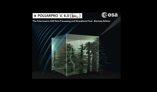
PolSARpro v6.0 (Biomass Edition) software new release
Download the latest version of ESA's Polarimetric SAR data Processing and Educational Toolbox (PolSARpro).
Tools - Processing
PolSARpro
PolSARpro is a toolbox for the scientific exploitation of polarimetric SAR data and a tool for high-level education in radar polarimetry.
Document - General Reference
PolInSAR-2013-session-summaries-recommendations.pdf
This document provides the session summaries and recommendations from the PolInSAR 2013 workshop.
Event - Workshop
POLinSAR 2019
ESA organised POLinSAR 2019, the 9th International Workshop on Science and Applications of SAR Polarimetry and Polarimetric Interferometry.
Event - Workshop
POLinSAR 2013
The objectives of the PolInSAR 2013 workshop were to present the latest studies and results of SAR polarimetry and polarimetric interferometry.
Event - Workshop
POLinSAR 2007
The POLinSAR 2007 workshop was open to ESA Principal Investigators and co-investigators, scientists and students working in the field of SAR Polarimetry and Polarimetric Interferometry, and to representatives from national, European and international space agencies and value adding industry.


