- All Categories (46)
- Data (11)
- News (10)
- Missions (1)
- Events (8)
- Activities (1)
- Campaigns (13)
- Documents (2)
Event - Workshop
Workshop on International Cooperation in Spaceborne Imaging Spectroscopy
The workshop aimed to recommend future international coordination permitting cooperation in the deployment, operation, and exploitation of space-based imaging spectrometers for terrestrial and coastal scientific and operational applications.
News - Infographics
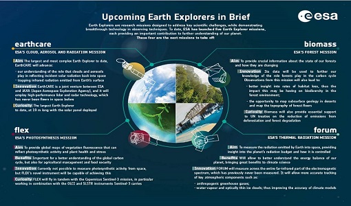
What are the next Earth Explorers?
Learn about the planned missions in the Earth Explorers programme - EarthCARE, Biomass, FLEX, and FORUM - which will further our understanding of Earth’s climate.
Campaign
SPARC
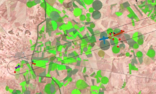
ESA's SPectra bARrax Campaign (SPARC) activity was part of the preparatory study for a proposed ESA Earth Explorer mission called SPECTRA. The objective was to collect a CHRIS/PROBA reference dataset for SPECTRA-related studies.
Data - Campaigns (Open)
SPARC
ESA's SPectra bARrax Campaign (SPARC) activity was part of the preparatory study for a proposed ESA Earth Explorer mission called SPECTRA. The objective was to collect a CHRIS/PROBA reference dataset for SPECTRA-related studies.
News - Thematic area articles
Space data support Earth’s ecosystems
ESA’s Earth observation (EO) missions are making a critical contribution to monitoring transformations in our planet’s ecosystems, helping track changes in the vegetation, soil, and ocean that affect these systems.
Campaign
SoyFLEX II 2016
The SoyFLEX II experiment was a repetition of an experiment that took place during the 2015 campaign in Germany.
Campaign
SoyFLEX 2015
SoyFLEX 2015 took place over the agricultural area around Jülich, Germany and Rzecin wetland site, Poland
Campaign
SIFLEX
The Solar Induced Fluorescence Experiment (SIFLEX) 2002 campaign was to understand whether solar-induced fluorescence measurements might someday be used to monitor and map the photochemical activity of boreal forests from space.
Campaign
SEN2FLEX
SENtinel-2 and FLuorescence EXperiment (SEN2FLEX) campaign combines different activities in support of initiatives related both to fluorescence experiments and Sentinel-2 initiative for prototyping of resolutions to meet mission requirements.
Data - Campaigns (Open)
SEN2FLEX
SENtinel-2 and FLuorescence EXperiment (SEN2FLEX) campaign combines different activities in support of initiatives related both to fluorescence experiments and Sentinel-2 initiative for prototyping of resolutions to meet mission requirements.
Campaign
SEN2EXP
In the SEN2EXP campaign, the data gap for broad leaf forests is addressed as suitable reference datasets of sufficient quality do not exist.
Data - Campaigns (Open)
SEN2EXP
In the SEN2EXP campaign, the data gap for broad leaf forests is addressed as suitable reference datasets of sufficient quality do not exist.
News - Thematic area articles
Satellite data boost global understanding of land surface
Understanding our changing land surface is essential in the study of climate change. Satellites are used to monitor changes to the material that covers Earth’s surface, so-called land cover, such as vegetation and water.
Data - EO Sign In Authentication (Open)
PROBA-1 HRC
The HRC Level 1A product is an image with a pixel resolution of 8m. The data are grey scale images, an image contains 1026 x 1026 pixels and covers an area of 25 km2. HRC data is supplied in BMP format. All PROBA-1 passes are systematically acquired according to the current acquisition plan, HRC data are processed every day to Level 1A and made available to ESA users. Spatial coverage: Check the spatial coverage of the collection on a map available on the Third Party Missions Dissemination Service.
Data - EO Sign In Authentication (Open)
PROBA-1 CHRIS Level 1A
CHRIS acquired a set of up to five images of each target during each acquisition sequence, these images were acquired when PROBA-1 was pointing at distinct angles with respect to the target. CHRIS Level 1A products (supplied in HDF data files, version 4.1r3) include five formal CHRIS imaging modes, classified as modes 1 to 5: Mode Name Swath Spectral Bands/Ground Resolution Mode 1 Aerosols 13 km 62 at 34 m (773 nm / 1036 nm) Mode 2 Water bands 13 km 18 at 18 m Mode 3 Land channels 13 km 18 at 18 m Mode 4 Chlorophyll band set 13 km 18 at 18 m Mode 5 Land channels 6.5 km 37 at 18 m Spatial coverage: Check the spatial coverage of the collection on a map available on the Third Party Missions Dissemination Service.
Event - Workshop
PROBA-1 CHRIS End of Mission Workshop
The PROBA-1 CHRIS End of Mission Workshop will take place from 18-19 January 2024 in Ghent, Belgium.
News - Infographics
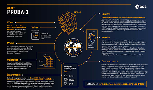
PROBA-1 - From technology demonstration to long-term Earth observation
Learn about ESA's PROBA-1 (Project for On-Board Autonomy) mission in our new infographic.
Mission - Third Party Missions
PROBA-1
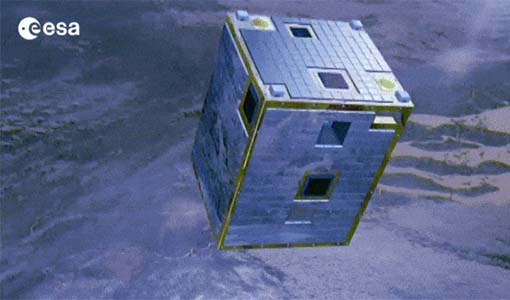
PROBA-1 is a technology demonstration satellite that later became an operational Earth observation mission.
Campaign
PhotoProxy 2019
The Photosynthetic-Proxy Experiment campaign address relevant open aspects that are related to the quantitative assessment of vegetation photosynthesis and vegetation stress from space.
Data - Campaigns (Open)
PhotoProxy 2019
The Photosynthetic-Proxy Experiment campaign address relevant open aspects that are related to the quantitative assessment of vegetation photosynthesis and vegetation stress from space.
