- All Categories (32)
- Data (6)
- News (10)
- Missions (7)
- Tools (3)
- Activities (4)
- Documents (2)
Mission - Third Party Missions

WorldView-4
WorldView-4 was an imaging and environment-monitoring satellite from Maxar of the United States, which offered very high resolution imagery.
Data - Sample Data (Open)
WorldView-3 Sample Data
Download free WorldView-3 sample datasets to preview products available for this mission.
News - Success Stories

WorldView-3 helps to track offshore methane plumes from oil and gas
Scientists have used Earth observation data to reveal enormous methane plumes spilling out from an offshore oil and gas production rig in the Gulf of Mexico. This represents a significant breakthrough in the monitoring of industrial methane emissions from space.
Data - Project Proposal (Restrained)

WorldView-3 full archive and tasking
WorldView-3 high resolution optical products are available as part of the Maxar Standard Satellite Imagery products from the QuickBird, WorldView-1/-2/-3/-4, and GeoEye-1 satellites. All details about the data provision, data access conditions and quota assignment procedure are described into the Terms of Applicability available in Resources section. In particular, WorldView-3 offers archive and tasking panchromatic products up to 0.31m GSD resolution, 4-Bands/8-Bands products up to 1.24 m GSD resolution, and SWIR products up to 3.70 m GSD resolution. Band Combination Data Processing Level Resolution High Res Optical: Panchromatic and 4-bands Standard(2A)/View Ready Standard (OR2A) 15 cm HD, 30 cm HD, 30 cm, 40 cm, 50/60 cm View Ready Stereo 30 cm, 40 cm, 50/60 cm Map Ready (Ortho) 1:12.000 Orthorectified 15 cm HD, 30 cm HD, 30 cm, 40 cm, 50/60 cm High Res Optical: 8-bands Standard(2A)/View Ready Standard (OR2A) 30 cm, 40 cm, 50/60 cm View Ready Stereo 30 cm, 40 cm, 50/60 cm Map Ready (Ortho) 1:12.000 Orthorectified 30 cm, 40 cm, 50/60 cm High Res Optical: SWIR Standard(2A)/View Ready Standard (OR2A) 3.7 m or 7.5 m (depending on the collection date) Map Ready (Ortho) 1:12.000 Orthorectified 4-Bands being an optional from: 4-Band Multispectral (BLUE, GREEN, RED, NIR1) 4-Band Pan-sharpened (BLUE, GREEN, RED, NIR1) 4-Band Bundle (PAN, BLUE, GREEN, RED, NIR1) 3-Bands Natural Colour (pan-sharpened BLUE, GREEN, RED) 3-Band Colored Infrared (pan-sharpened GREEN, RED, NIR1) 8-Bands being an optional from: 8-Band Multispectral (COASTAL, BLUE, GREEN, YELLOW, RED, RED EDGE, NIR1, NIR2) 8-Band Bundle (PAN, COASTAL, BLUE, GREEN, YELLOW, RED, RED EDGE, NIR1, NIR2) Native 30 cm and 50/60 cm resolution products are processed with MAXAR HD Technology to generate respectively the 15 cm HD and 30 cm HD products: the initial special resolution (GSD) is unchanged but the HD technique increases the number of pixels and improves the visual clarity achieving aesthetically refined imagery with precise edges and well reconstructed details. As per ESA policy, very high-resolution imagery of conflict areas cannot be provided.
Mission - Third Party Missions
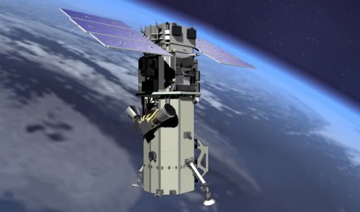
WorldView-3
WorldView-3 is the first multi-payload, super-spectral, high-resolution commercial satellite sensor operating at an altitude of 617 km. WorldView-3 is capable of collecting up to 680,000 square km per day.
Data - Project Proposal (Restrained)

WorldView-2 full archive and tasking
WorldView-2 high resolution optical products are available as part of the Maxar Standard Satellite Imagery products from the QuickBird, WorldView-1/-2/-3/-4, and GeoEye-1 satellites. All details about the data provision, data access conditions and quota assignment procedure are described into the Terms of Applicability available in Resources section. In particular, WorldView-2 offers archive and tasking panchromatic products up to 0.46 m GSD resolution, and 4-Bands/8-Bands Multispectral products up to 1.84 m GSD resolution. Band Combination Data Processing Level Resolution Panchromatic and 4-bands Standard (2A)/View Ready Standard (OR2A) 15 cm HD, 30 cm HD, 30 cm, 40 cm, 50/60 cm View Ready Stereo 30 cm, 40 cm, 50/60 cm Map-Ready (Ortho) 1:12.000 Orthorectified 15 cm HD, 30 cm HD, 30 cm, 40 cm, 50/60 cm 8-bands Standard(2A)/View Ready Standard (OR2A) 30 cm, 40 cm, 50/60 cm View Ready Stereo 30 cm, 40 cm, 50/60 cm Map-Ready (Ortho) 1:12.000 Orthorectified 30 cm, 40 cm, 50/60 cm 4-Bands being an optional from: 4-Band Multispectral (BLUE, GREEN, RED, NIR1) 4-Band Pan-sharpened (BLUE, GREEN, RED, NIR1) 4-Band Bundle (PAN, BLUE, GREEN, RED, NIR1) 3-Bands Natural Colour (pan-sharpened BLUE, GREEN, RED) 3-Band Colored Infrared (pan-sharpened GREEN, RED, NIR1). 8-Bands being an optional from: 8-Band Multispectral (COASTAL, BLUE, GREEN, YELLOW, RED, RED EDGE, NIR1, NIR2) 8-Band Bundle (PAN, COASTAL, BLUE, GREEN, YELLOW, RED, RED EDGE, NIR1, NIR2). Native 30 cm and 50/60 cm resolution products are processed with MAXAR HD Technology to generate respectively the 15 cm HD and 30 cm HD products: the initial special resolution (GSD) is unchanged but the HD technique increases the number of pixels, improves the visual clarity and allows to obtain an aesthetically refined imagery with precise edges and well reconstructed details. As per ESA policy, very high-resolution imagery of conflict areas cannot be provided.
Data - Project Proposal (Restrained)

WorldView-2 European Cities
ESA, in collaboration with European Space Imaging, has collected this WorldView-2 dataset covering the most populated areas in Europe at 40 cm resolution. The products have been acquired between July 2010 and July 2015. Spatial coverage: Check the spatial coverage of the collection on a map available on the Third Party Missions Dissemination Service.
Mission - Third Party Missions
WorldView-2
WorldView-2 is an environment-monitoring satellite from Maxar which presents images as the human eye can perceive them, creating a more realistic 'true colour' view of the world.
Mission - Third Party Missions

WorldView Series
The WorldView constellation are environment-monitoring satellites that have been supplying imagery since 2007.
Data - Fast Registration with approval (Restrained)

WorldView ESA archive
The WorldView ESA archive is composed of products acquired by WorldView-1, -2, -3 and -4 satellites and requested by ESA supported projects over their areas of interest around the world Panchromatic, 4-Bands, 8-Bands and SWIR products are part of the offer, with the resolution at Nadir depicted in the table. Band Combination Mission GSD Resolution at Nadir GSD Resolution (20° off nadir) Panchromatic WV-1 50 cm 55 cm WV-2 46 cm 52 cm WV-3 31 cm 34 cm WV-4 31 cm 34 cm 4-Bands WV-2 1.84 m 2.4 m WV-3 1.24 m 1.38 m WV-4 1.24 m 1.38 m 8-Bands WV-2 1.84 m 2.4 m WV-3 1.24 m 1.38 m SWIR WV-3 3.70 m 4.10 m The 4-Bands includes various options such as Multispectral (separate channel for Blue, Green, Red, NIR1), Pan-sharpened (Blue, Green, Red, NIR1), Bundle (separate bands for PAN, Blue, Green, Red, NIR1), Natural Colour (pan-sharpened Blue, Green, Red), Coloured Infrared (pan-sharpened Green, Red, NIR). The 8-Bands being an option from Multispectral (COASTAL, Blue, Green, Yellow, Red, Red EDGE, NIR1, NIR2) and Bundle (PAN, COASTAL, Blue, Green, Yellow, Red, Red EDGE, NIR1, NIR2). The processing levels are: Standard (2A): normalised for topographic relief View Ready Standard: ready for orthorectification (RPB files embedded) View Ready Stereo: collected in-track for stereo viewing and manipulation (not available for SWIR) Map Scale (Ortho) 1:12,000 Orthorectified: additional processing unnecessary Spatial coverage: Check the spatial coverage of the collection on a map available on the Third Party Missions Dissemination Service. The following table summarises the offered product types EO-SIP Product Type Band Combination Processing Level Missions WV6_PAN_2A Panchromatic (PAN) Standard/View Ready Standard WorldView-1 and 4 WV6_PAN_OR Panchromatic (PAN) View Ready Stereo WorldView-1 and 4 WV6_PAN_MP Panchromatic (PAN) Map Scale Ortho WorldView-1 and 4 WV1_PAN__2A Panchromatic (PAN) Standard/View Ready Standard WorldView-2 and 3 WV1_PAN__OR Panchromatic (PAN) View Ready Stereo WorldView-2 and 3 WV1_PAN__MP Panchromatic (PAN) Map Scale Ortho WorldView-2 and 3 WV1_4B__2A 4-Band (4B) Standard/View Ready Standard WorldView-2, 3 and 4 WV1_4B__OR 4-Band (4B) View Ready Stereo WorldView-2, 3 and 4 WV1_4B__MP 4-Band (4B) Map Scale Ortho WorldView-2, 3 and 4 WV1_8B_2A 8-Band (8B) Standard/View Ready Standard WorldView-2 and 3 WV1_8B_OR 8-Band (8B) View Ready Stereo WorldView-2 and 3 WV1_8B_MP 8-Band (8B) Map Scale Ortho WorldView-2 and 3 WV1_S8B__2A SWIR Standard/View Ready Standard WorldView-3 WV1_S8B__MP SWIR Map Scale Ortho WorldView-3 As per ESA policy, very high-resolution imagery of conflict areas cannot be provided.
News - Events and Proceedings

VHR Data Quality in the limelight
In recent years, the satellite landscape has steadily expanded with a variety of very high resolution (VHR) commercial satellites, also emerging from new space providers. A result of this growth is an increased need to address data quality assurance.
Activity - Projects

TOLEOS
The TOLEOS (Thermosphere Observations from Low-Earth Orbiting Satellites) project will produce thermosphere mass density observations from the accelerometer measurements of the GRACE, GRACE-FO, and CHAMP satellites.
Tools - Other
Swarm-Aurora
Swarm-Aurora, a web-based tool, was designed to facilitate and drive the use of Swarm in-situ measurements in auroral science.
News - Announcement of Opportunity updates
Swarm DISC Deadline Extension
Swarm DISC Invitation to Tender deadline extension for SD-ITT-4.4: Swarm for Space Weather
Mission - Earth Explorers
Swarm
Swarm is dedicated to creating a highly detailed survey of Earth’s geomagnetic field and its temporal evolution as well as the electric field in the atmosphere using a constellation of three identical satellites.
News - Success Stories

Remote sensing scientists raise alarm for African savannah
Researchers have used high resolution WorldView-3 imagery to map vegetation cover in the Greater Maasai Mara savannah, a global hotspot for biodiversity in Kenya.
News - General News

New paper “Swarm Langmuir probes' data quality validation and future improvements” published
The paper “Swarm Langmuir probes' data quality validation and future improvements” by F. Catapano et al. has been published in the Geoscientific Instrumentation, Methods and Data Systems (GI) journal in March 2022.
News - Success Stories

How Envisat helped to shape global understanding of Earth’s systems
Twenty years have passed since a ground-breaking European spacecraft designed to deliver unprecedented insight into the planet’s changing environment was lofted into orbit.
News - Events and Proceedings

Highlights from Living Planet Symposium
As remote sensing scientists and data-users from around the world converged at the Living Planet Symposium (LPS) in Bonn recently, a common thread was evident in many scientific sessions and meetings – the right environmental data can accelerate our understanding of the rapid changes in Earth’s system.
Activity - General activities

GSCB and LTDP
The Copernicus programme is based on a fleet of European Earth observation satellites, built and operated by ESA, member states and commercial entities. Copernicus will also offer data from non-European satellites.