- All Categories (60)
- Data (16)
- News (16)
- Missions (5)
- Events (8)
- Tools (1)
- Activities (2)
- Campaigns (11)
- Documents (1)
News - General News

ESA's improved Earth system data records: what is in store for the future?
Fundamental Data Records (FDRs) are instrumental in advancing our understanding of Earth systems and for addressing societal challenges effectively. These long-term records contain uncertainty-quantified, calibrated and geo-located multi-instrument/multi-platform satellite sensor data spanning several decades to support climate-related applications.
Document - Newsletter

Earth Online Newsletter - 08 March 2024
This issue of the Earth Online Newsletter covers a selection of the latest news and events from ESA.
News - Data Release news
FDR4ALT - ESA unveils new cutting-edge ERS/Envisat Altimeter and Microwave Radiometer Datasets
The European Space Agency (ESA) has developed a comprehensive suite of innovative Earth system data records as part of the Fundamental Data Records for Altimetry project - FDR4ALT.
Data - EO Sign In Authentication (Open)
Land Ice Thematic Data Product [ALT_TDP_LI]
This is the Land Ice Thematic Data Product (TDP) V1 resulting from the ESA FDR4ALT project and containing estimates of ice sheet surface elevation and associated uncertainties. The collection covers data for three different missions: ERS-1, ERS-2 and Envisat, and based on Level 1 data coming from previous reprocessing (ERS REAPER and the Envisat V3.0) but taking into account the improvements made at Level 0/Level 1 in the frame of FDR4ALT (ALT FDR). The Land Ice TDP focuses specifically on the ice sheets of Greenland and Antarctica, providing these data in different files. For many aspects, the Land Ice Level 2 and Level 2+ processing is very innovative: Improved relocation approach correcting for topographic effects within the beam footprint to identify the Point of Closest Approach Homogeneous timeseries of surface elevation measurements at regular along-track reference nodes. The FDR4ALT products are available in NetCDF format. Free standard tools for reading NetCDF data can be used. Information for expert altimetry users is also available in a dedicated NetCDF group within the products. Please consult the FDR4ALT Product User Guide before using the data. The FDR4ALT datasets represent the new reference data for the ERS/Envisat altimetry missions, superseding any previous mission data. Users are strongly encouraged to make use of these datasets for optimal results.
News - Data Release news
MOS-1/1B MESSR and VTIR data products now available
MOS-1/1B MESSR (Multi-spectral Electronic Self-Scanning Radiometer) and VTIR (Visible and Thermal Infrared Radiometer) level 1 data products are now available via the ESA Heritage Missions Dissemination System.
Mission - Heritage Missions
MOS-1/1B
MOS-1 and 1B, Japan’s first marine observation satellites, were designed to monitor ocean currents, sea surface temperature, atmospheric water vapour, ocean chlorophyll levels, precipitation, and land vegetation.
News - Data Release news
Envisat MIPAS data now available on new ESA Dissemination Server
The latest reprocessed Envisat MIPAS Level 1 and Level 2 datasets have now been migrated from simple FTP access to the new Online Dissemination service for ESA Heritage Missions (HM) Atmospheric data.
Mission - Third Party Missions
FSSCat
The FSSCat mission was an innovative concept that consisted of two federated 6-Unit Cubesats, called ³Cat-5/A and ³Cat-5/B, which operated in support of the Copernicus Land and Marine Environment services.
News - Thematic area articles

Satellites investigate Earth’s terrestrial hydrosphere
ESA’s Earth observation satellites are playing a leading role in furthering our understanding of how Earth’s water cycle is being influenced by humankind.
News - Success Stories

Decades of satellite data reveal the risks of climate tipping points
Decades-long time series that draw on ESA’s Earth observation archives are enabling scientists to uncover the threat of sudden and potentially irreversible changes to the icy parts of the planet.
News - Success Stories

Tracking mountainous glaciers using TanDEM-X
Ice melting from mountain glaciers is one of the largest contributors to sea-level rise outside the large ice sheets of Antarctica and Greenland. New research leveraging the vast data from the TanDEM-X mission, has successfully mapped glacial elevation change over multiple mountainous regions of the world.
News - Thematic area articles

Satellites reveal changes to Earth’s icy zones
ESA’s Earth observation activities are helping scientists investigate the influence of climate change on widespread ice-losses across the planet.
Activity - Projects

Contribution of Swarm data to the prompt detection of Tsunamis and other natural hazards
The main objective of COSTO (Contribution of Swarm data to the prompt detection of Tsunamis and other natural hazards) project is to better characterise, understand and discover coupling processes and interactions.
Data - Project Proposal (Restrained)
Vision-1 full archive and tasking
Vision-1 provides very high resolution optical products, with 87cm resolution in Panchromatic mode and 3.48m in Multispectral Mode. Products are in DIMAP format; the image is in GeoTiff format with 16 bit encoding; the applied geographical projection is WGS84 UTM. Spectral band combination options: Panchromatic (PAN): includes data contained within a single high resolution black and white band, with product pixel size of 0.87m Multispectral (MS4): includes four multispectral (colour) bands: Blue, Green, Red and Near Infrared. The product pixel size is 3.48m Bundle (BUN): provides both the 4-band multispectral, and the panchromatic data from the same acquisition in a single, non-merged product. Data is provided as 16-bit GeoTiffs with pixel sizes of 3.48m and 0.87m for MS and PAN data respectively Pansharpened (PSH): single higher resolution 0.87 colour product obtained by the combination of the visual coloured information of the multispectral data with the details provided in the panchromatic data. Two different geometric processing levels are: Projected (level 2): The product is mapped onto the Earth cartographic system using a standard reference datum and projection system at a constant terrestrial altitude, relative to the reference ellipsoid. By default, the map projection system is WGS84/UTM. The image is georeferenced without the application of a Digital Elevation Model (DEM) and supplied with the RPC model file. Pansharpened are not available as projected product Standard Ortho (level 3): georeferenced image in Earth geometry, including the application of a Airbus World DEM for Ortho and GCPs (using Airbus Intelligence One Atlas BaseMap as reference). The orthorectification procedure eliminates the perspective effect on the ground (excluding buildings) to restore the geometry of a vertical shot. Only the basic radiometric processing is available providing the radiance value. As per ESA policy, very high-resolution imagery of conflict areas cannot be provided.
News - Data Release news
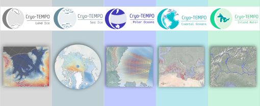
New CryoSat-2 Thematic Products Now Available
As of January 2022, ESA has started releasing new CryoSat-2 Thematic Products, dedicated to five distinct areas: Sea Ice, Land Ice, Polar Oceans, Coastal Oceans and Inland Waters.
Event - Workshop

Fringe 2003 Workshop
The third ESA International Workshop on ERS SAR Interferometry and its first Workshop on ASAR interferometry: Advances in SAR interferometry from ERS and Envisat missions.
News - Success Stories

COP26 fuels interest in satellite data
As COP26 stimulates action to reduce global warming, the essential role of satellite data in understanding and monitoring climate change is apparent.
News - Data Release news

SMOS sea ice thickness Arctic winter season 2021/2022 data available
SMOS Sea Ice thickness level 3 and level 4 data products are now available for the Arctic winter season 2021/2022.
Event - Workshop
Fringe 1996 Workshop
The workshop on ERS SAR Interferometry was open to scientists and students working in the field of Synthetic Aperture Radar (SAR) interferometry and its applications.
Data - Project Proposal (Restrained)

WorldView-4 Full Archive
WorldView-4 high resolution optical products are available as part of the Maxar Standard Satellite Imagery products from the QuickBird, WorldView-1/-2/-3/4, and GeoEye-1 satellites. All details about the data provision, data access conditions and quota assignment procedure are described into the Terms of Applicability available in Resources section. In particular, WorldView-4 offers archive panchromatic products up to 0.31 m GSD resolution, and 4-Bands Multispectral products up to 1.24 m GSD resolution. Band Combination Data Processing Level Resolution Panchromatic and 4-bands Standard (2A) / View Ready Standard (OR2A) 15 cm HD, 30 cm HD, 30 cm, 40 cm, 50/60 cm View Ready stereo 30 cm, 40 cm, 50/60 cm Map Ready (Ortho) 1:12.000 Orthorectified 15 cm HD, 30 cm HD, 30 cm, 40 cm, 50/60 cm The options for 4-Bands are the following: 4-Band Multispectral (BLUE, GREEN, RED, NIR1) 4-Band Pan-sharpened (BLUE, GREEN, RED, NIR1) 4-Band Bundle (PAN, BLUE, GREEN, RED, NIR1) 3-Bands Natural Colour (pan-sharpened BLUE, GREEN, RED) 3-Band Colored Infrared (pan-sharpened GREEN, RED, NIR1) Native 30 cm and 50/60 cm resolution products are processed with MAXAR HD Technology to generate respectively the 15 cm HD and 30 cm HD products: the initial special resolution (GSD) is unchanged but the HD technique increases the number of pixels and improves the visual clarity achieving aesthetically refined imagery with precise edges and well-reconstructed details.