- All Categories (273)
- Data (27)
- News (44)
- Missions (3)
- Events (31)
- Tools (17)
- Activities (12)
- Campaigns (1)
- Documents (138)
Activity - Cal/Val activities
UV nadir viewing galleries
Atmospheric chemistry nadir observation from space now spans nearly forty years. The early UVN (UV nadir missions) mainly focused on measuring ozone.
News - Data Release news
Updated Precise Orbit data (POD) for the full ERS-1 and ERS-2 mission available
The Precise Orbit files (ERS.ORB.POD) for the entire ERS-1 and ERS-2 mission periods have been reprocessed with up-to-date standards.
News - Thematic area articles
Transforming space data into climate action
ESA’s Earth observation activities are playing a key role in the revitalised global drive to combat climate change.
News - Success Stories
Trailblazing ERS-2 mission enables climate change applications
As ESA’s ERS-2 satellite approaches Earth’s atmosphere for reentry, it’s time to reflect on the mission’s great achievements in powering climate-related applications.
Document - User Guide
TPM-L-OADS-dissemination-service-User-Manual.pdf
This guide describes the Third Party Missions Dissemination System.
News - Infographics
Timeline to over 40 years of historical satellite missions
ESA's Heritage Space Programme preserves historical data from over 40 years of Earth observation missions.
Document - General Reference
Third Party Missions Brochure
This brochure summarises ESA's Third Party Missions programme, providing a timeline and examples of content related to some of the missions.
Document - Proceedings
Third ESA International Conference on Spacecraft Guidance, Navigation and Control Systems
The proceedings from the Third ESA International Conference on Spacecraft Guidance, Navigation and Control Systems, which took place at ESTEC in Noordwijk, the Netherlands, from 26 to 29 November 1996, are presented here.
Document - Technical Note
SPOTScene-SPOTView-preprocessing-levels.pdf
SPOT technical information - SPOTScene and SPOTView preprocessing levels
Data - Fast Registration with approval (Restrained)
SPOT 1-5 ESA archive
The ESA SPOT 1-5 collection is a dataset of SPOT 1 to 5 Panchromatic and Multispectral products that ESA collected over the years. The HRV(IR) sensor onboard SPOT 1-4 provides data at 10 m spatial resolution Panchromatic mode (-1 band) and 20 m (Multispectral mode -3 or 4 bands). The HRG sensor on board of SPOT-5 provides spatial resolution of the imagery to < 3 m in the panchromatic band and to 10 m in the multispectral mode (3 bands). The SWIR band imagery remains at 20 m. The dataset mainly focuses on European and African sites but some American, Asian and Greenland areas are also covered. Spatial coverage: Check the spatial coverage of the collection on a map available on the Third Party Missions Dissemination Service. The SPOT Collection
News - General News
SPOT 1 to 5 production to be suspended
Airbus will suspend the production of SPOT 1 to 5 data until further notice at the end of May 2020.
News - General News
SPOT 1 to 5 production now suspended
Following the news of 14 May 2020, Airbus will now suspend the production of SPOT 1 to 5 data.
Mission - Heritage Missions
SPOT 1
SPOT 1 was designed to improve the knowledge and management of Earth's resources, detecting and forecasting phenomena involving climatology and oceanography, and monitoring human activities and natural phenomena.
Mission - Heritage Missions
SPOT
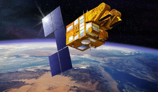
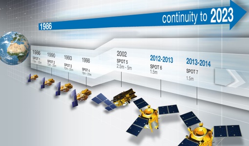
The SPOT (from French "Satellite pour l'Observation de la Terre") series of missions has been supplying high-resolution, wide-area optical imagery since 1986.
Event - Workshop
Space and the Arctic 2009 Workshop
Temperatures in the Arctic are rising at an unprecedented rate. This workshop looked at the needs and challenges of working and living in the rapidly changing Arctic and explore how space-based services might help to meet those needs.
Tools - Analysis
SNAP
SNAP is a common architecture for all Sentinel Toolboxes. It is ideal for Earth observation processing and analysis.
Document - Publication - Paper
Smith_Lesson_learned_from_AATSR_and_SLSTR_prelaunch_cal.pdf
EO-Level1-Lessons-Learned-Workshop-presentation
News - Infographics
Showcasing success stories from ESA's Heritage Missions
Find out how ESA's Heritage Space Programme data continue to help, even decades after they finished operations, in our latest infographic.


