- All Categories (32)
- Data (3)
- News (13)
- Missions (2)
- Events (4)
- Tools (1)
- Activities (2)
- Documents (7)
News - Infographics
Showcasing the atmosphere-studying Odin mission
Learn about the Odin mission in our new infographic.
News - Success Stories

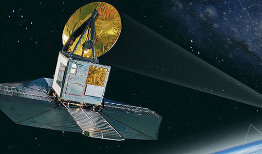
Atmosphere-studying Odin mission enjoys ongoing success
More than two decades after it began operations, the Odin remote sensing satellite is continuing to make strong contributions to high-impact atmospheric science.
News - Success Stories

Long-term satellite data show wind farms can affect local air currents
Decades of satellite data have allowed for the first long-term study of the impact of offshore wind farms on downstream wind flow in coastal areas.
Data - EO Sign In Authentication (Open)
ICEYE ESA archive
The ICEYE ESA archive collection consists of ICEYE Level 1 products requested by ESA supported projects over their areas of interest around the world. The dataset regularly grows as ESA collects new products over the years. Three different modes are available: Spot: With a slant resolution of 50 cm in range by 25 cm in azimuth that translated into the ground generates a ground resolution of 1 m over an area of 5 km x 5 km. Due to multi-looking, speckle noise is significantly reduced Strip: The ground swath is 30 x 50 km2 and the ground range resolution is 3 m Scan: A large area (100 km x 100 km is acquired with ground resolution of 15 m). Two different processing levels: Single Look Complex (SLC): Level 1A geo-referenced product and stored in the satellite's native image acquisition geometry (the slant imaging plane) Ground Range Detected (GRD): Level 1B product; detected, multi-looked and projected to ground range using an Earth ellipsoid model; the image coordinates are oriented along the flight direction and along the ground range; no image rotation to a map coordinate system is performed, interpolation artefacts not introduced. The following table defines the offered product types: EO-SIP Product Type Mode Processing level XN_SM__SLC Strip Single Look Complex (SLC) - Level 1A XN_SM__GRD Strip Ground Range Detected (GRD) - Level 1B XN_SL__SLC Spot Single Look Complex (SLC) - Level 1A XN_SL__GRD Spot Ground Range Detected (GRD) - Level 1B XN_SR__GRD Scan Ground Range Detected (GRD) - Level 1B As per ESA policy, very high-resolution data over conflict areas cannot be provided.
News - Success Stories

Satellites track the health of the ozone layer
ESA’s Earth observation activities are contributing to international efforts to monitor and preserve the layer of stratospheric ozone that blankets the planet.
News - Thematic area articles

Space data help to unravel the complexities of Earth’s atmosphere
As the impacts of the climate crisis intensify, scientists are using ESA’s Earth observation archives to investigate atmospheric processes and their influences on the planet’s changing environment.
News - Data Release news

TerraSAR-X/TanDEM-X WorldDEM data now available to users
WorldDEM products have been added to the TerraSAR-X/TanDEM-X offering and are now available to users for research and application development following submission of a project proposal subject to evaluation and acceptance by ESA and the data owner.
News - Success Stories

Earth Observation data to improve navigation risk modelling and shipping routes
With the increased frequency of shipping activities, such as tourism and transport of freights, navigation safety has become a major concern. Even if new technologies have already supplied aids to pilots for navigation risk reduction, the International Maritime Organisation (IMO) reports that the majority of accidents could have been avoided by providing suitable input to the navigation decision-making process — this is where Earth Observation data can represent complementary information, to improve traffic monitoring and guidance along safe routes.
Activity - General activities

GSCB and LTDP
The Copernicus programme is based on a fleet of European Earth observation satellites, built and operated by ESA, member states and commercial entities. Copernicus will also offer data from non-European satellites.
Data - Data Description
Odin SMR data products
The latest Odin Sub-Millimetre Radiometer (SMR) datasets have been generated by Chalmers University of Technology and Molflow within the Odin-SMR Recalibration and Harmonisation project, funded by the European Space Agency (ESA) to create a fully consistent and homogeneous dataset from the 20 years of satellite operations. The Odin satellite was launched in February 2001 as a joint undertaking between Sweden, Canada, France and Finland, and is part of the ESA Third Party Missions (TPM) programme since 2007. The complete Odin-SMR data archive was reprocessed applying a revised calibration scheme and upgraded algorithms. The Level 1b dataset is entirely reconsolidated, while Level 2 products are regenerated for the main mesospheric and stratospheric frequency modes (i.e., FM 01, 02, 08, 13, 14, 19, 21, 22, 24). The resulting dataset represents the first full-mission reprocessing campaign of the mission, which is still in operation.
Document - Proceedings

Fringe-2011-workshop-recommendations.pdf
This document contains the recommendations from the session summaries of the Fringe 2011 Workshop.
News - Data Release news
Release of Odin SMR reprocessed data
Data from the Odin Sub-Millimetre Radiometer (SMR) reprocessing has been released to users and is now freely available.
Event - Workshop

SEASAR 2012
The European Space Agency and the Norwegian Space Centre jointly organised the fourth SAR oceanography workshop, 'SEASAR 2012', entitled 'Advances in SAR Oceanography'.
Event - Workshop

Fringe 2011 Workshop
Fringe 2011 was the 8th International Workshop on "Advances in the Science and Applications of SAR Interferometry".
News - General News

PAZ data now available to users worldwide
ESA is pleased to announce the availability of the PAZ satellite products to the scientific community, for R&D activities and start-ups.
News - General News

ICEYE data available for assessment
The SAR user community is invited to participate to the call to assess the suitability of the ICEYE constellation, for science and EO-based applications.
Document - User Guide

ICEYE-SAR-Product-Guide-V4.pdf
The ICEYE SAR Product Guide provides the SAR Product Specifications, a detailed description of the Image Ordering process, and related supporting information.
Tools - Visualisation
EVDC Orbit Prediction Tool
The EVDC Orbit Prediction and Overpass Tool generates and visualises satellite's overpasses.
Data - Campaigns (Open)

TerraSARSIM
The objectives of the TerraSAR SIM project were to quantify the impact of the time intervals between SAR acquisitions at different wavelengths on agricultural applications.
Mission - Third Party Missions

TerraSAR-X and TanDEM-X
The TerraSAR-X and TanDEM-X satellites feature a unique geometric accuracy that is unmatched by any other spaceborne sensor.