- News
- Earth Observation data to impr...
Earth Observation data to improve navigation risk modelling and shipping routes
08 Oct 2021
With the increased frequency of shipping activities, such as tourism and transport of freights, navigation safety has become a major concern. Even if new technologies have already supplied aids to pilots for navigation risk reduction, the International Maritime Organisation (IMO) reports that the majority of accidents could have been avoided by providing suitable input to the navigation decision-making process — this is where Earth Observation data can represent complementary information, to improve traffic monitoring and guidance along safe routes.
NARAS is an ESA project carried out by S.A.T.E. Srl (as principal investigator), MARIN (the Maritime Research Institute Netherlands), and Planetek Italia Srl, matured as a spin-off from the results of a previous ESA activity carried out by S.A.T.E. and MARIN.
In the previous activity, the improvement of safety in critical maritime operations was targeted by extracting Preferred Routes for ships (described by environmental-dependent space-time way-points with a certain tolerance), using Big Data techniques on vast archives of Automatic Identification System (AIS, ship positions obtained from GNSS—Global Navigation Satellite System—receivers) and Vessel Traffic Service (VTS, marine traffic monitoring systems established by harbour or port authorities) data.
In an autonomous shipping scenario, vessels navigate following prescribed routes, adaptively changed based on risks and environmental conditions. GNSS and its augmentation systems will represent the key enabling technology to attain safety of navigation, especially considering systems providing accuracy and integrity information.
However, they may not be sufficient to assure such safety when ships are not using good quality GNSS receivers, or when they switch off positioning systems. Also, “non-collaborative” objects (ships/objects in the sea not transmitting AIS), such as natural and artificial debris, may represent possible hazards.
Therefore, Earth Observation (EO) data can be used to detect sailing vessels with no AIS receiver and to compare the AIS position versus position detected in optical and SAR images. The combined use of such EO data will increase available information and could provide support to vessel detection (shape, dimension and route).
NARAS aims at expanding the Preferred Route concept by exploiting the combination of EO and GNSS to improve navigation risk modelling and provide near real-time updates on preferred routes for navigating ships.
These targets are going to be achieved by combining AIS/VTS data with Synthetic Aperture Radar (SAR) and optical images, when the latter are available, to improve the detection of unreported features in the maritime AIS system and the statistical evaluation of the accuracy of current position data available through the AIS system, or their alignment with EO extracted positions.
The usage of the combined EO/GNSS information can provide fundamental support either for the shore assisted navigation or, in the future, for ships’ autonomous navigation.
In short, employing the potentialities standing out from the synergic exploitation of EO and AIS data, it is possible to:
- Extract preferred routes that can be suggested to ships in a certain area, based on the ship’s characteristics and on the environmental conditions;
- Observe objects in the sea not transmitting AIS (i.e. non-collaborative objects that are not transmitting an AIS signal, such as wind/solar offshore farms or containers);
- Monitor areas in the sea (e.g. to monitor an area or objects lost at sea after an accident);
- Verify quality of the AIS (e.g. to verify the quality or the precision of the AIS signal or to check if AIS base stations are working correctly);
- Predict trajectories of floating objects (as the drift of an object, e.g. a container, lost at sea depends on its drift properties - this might be more challenging as it requires high-resolution satellite images to estimate different characteristics of the vessel);
- Adjust in real-time the preferred routes recommended to ships, based on the position and trajectory of non-collaborative objects.
The Earth Observation dataset collected within the frame of the NARAS activities consists of 47 EO SAR products, acquired over three selected Areas of Interest:
- Venice, North Adriatic Sea (Italy),
- Rotterdam, North Sea (the Netherlands),
- Wadden Islands, North Sea (the Netherlands),
Using three different SAR missions:
- COSMO-SkyMed (26 StripMap and 1 ScanSAR-Wide with a spatial resolution of 2.5 m and 15 m respectively),
- ICEYE (15 StripMap with a spatial resolution of 3 m),
- TerraSAR-X (5 StripMap with a spatial resolution of 1.25 m).
NARAS EO products were collected from commercial European data providers in the frame of ESA’s Earthnet Programme, which made selected datasets available to users subject to ESA’s Cat.1 policy for ESA Third Party Missions (TPM).
- COSMO-SKyMed Full Archive and Tasking
- ICEYE full archive and tasking
- TerraSAR-x full archive and tasking
Additionally, data from the COSMO-SkyMed mission over the Italian territory have been provided by the Italian Space Agency, in the framework of the MAP ITALY project.
To provide some examples, Figure 1 shows the extracted groups of trajectories, which are typically covered by ships of Tank, Cargo or Passenger type and other, in the Wadden Islands area. These were extracted from a large set of AIS data, collected during several months and routes were characterised covered by the different types of ships and environmental conditions.
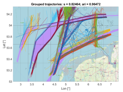
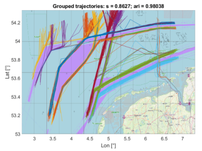
Figure 1: Wadden Islands grouped trajectories
Each group of trajectories is represented by a single “preferred path”, consisting of a set of waypoints and their boundaries, representing space and time tolerances. Figure 2 shows an example of preferred path used by Tankers to approach the coast.
The preferred paths extracted from the large AIS datasets will be used to monitor traffic and eventually adjusted, based on the non-AIS objects detected in the same area, thanks to EO data.
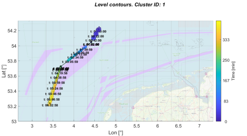
An example of objects (ships and potentially non-collaborative objects), detected at the same instant from AIS and EO data is shown in Figure 3. The red “x” objects are detected from an EO image covering the area highlighted in the figure, but not from AIS data. This shows that there are several objects in the area that are not transmitting AIS signals.
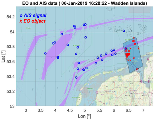
These data will be jointly used to monitor the traffic and suggest adjustments to the preferred paths assigned to ships in that area, based on the evolution of the traffic conditions.
Chiara Brighenti, project technical coordinator at S.A.T.E. for NARAS, comments, “Earth Observation data and their integration in operational models provide essential information for monitoring of objects lost at sea.”
Paolo Zoccarato, Technical Officer for ESA, adds, “This project is a beneficial step forward towards the enhancement of security in maritime applications, paving the path also for coming technologies. For example, autonomous vessels will require a very robust provision of environmental and navigation information based on multiple sources of observations, combining the strength of different techniques and mitigating the limitations of the single ones, while EO LEO satellite constellations will provide high-rate, near-real time images to be combined with GNSS sensing.”