- All Categories (938)
- Data (1)
- News (27)
- Missions (2)
- Events (11)
- Activities (2)
- Campaigns (2)
- Documents (893)
Event - Conference
2nd SMOS Science Conference
The conference focused on the applications of SMOS data, including operational services, the development of novel data products, the synergistic use of SMOS data with other data sources and the potential of SMOS data for the generation of long-term data sets.
Event - Workshop

2nd Space for Hydrology Workshop
The workshop aimed to assess the current stage of knowledge and activities in space-based hydrological observations and to exchange knowledge and know how with hydrologists and researchers.
Event - Training

3rd Advanced Training Course on Land Remote Sensing 2011
This 2011 advanced ESA training course focused on land remote sensing theory and applications.
Event - Training
Advanced Training Course in Land Remote Sensing 2012
The 2012 advanced training course focused on land remote sensing theory and applications.
News - Spotlight on EO community

An overview of the SMOS mission
In this video, Klaus Scipal - Biomass and SMOS Mission Manager - talks about ESA's Soil Moisture and Ocean Salinity mission.
Document - General Reference

ARTEMIS-Data-Relay-Payload-Data-Book.pdf
This document is intended as a guide to the user community wishing to avail themselves of the services provided by the data relay system, which is based on the ARTEMIS satellite located over Europe. This document describes the services that data relay can offer and the interface requirements applicable to the UST and the UET.
Document - General Reference
ARTEMIS-Moving-Forward-a-New-Generation-of-Communications.pdf
This brochure presents an overview of the telecommunications satellite, Artemis.
Document - General Reference
ARTEMIS-Paving-the-way-for-Europes-future-data-relay-land-mobile-and-Navigation-Services.pdf
This brochure provides an overview of Artemis, ESAs telecommunications satellite.
Data - EO Sign In Authentication (Open)
AVHRR Level-1B Local Area Coverage Imagery
This collection is composed of AVHRR L1B products (1.1 km) reprocessed from the NOAA POES and Metop AVHRR sensors data acquired at the University of Dundee and University of Bern ground stations and from the ESA and University of Bern data historical archive. The product format is the NOAA AVHRR Level 1B that combines the AVHRR data from the HRPT stream with ancillary information like Earth location and calibration data which can be applied by the user. Other appended parameters are time codes, quality indicators, solar and satellite angles and telemetry. Two data collections cover Europe and the neighbouring regions in the period of 1 January 1981 to 31 December 2020 and the acquired data in the context of the 1-KM project in the ‘90s. During the early 1990’s various groups, including the International Geosphere-Biosphere Programme (IGBP), the Commission of the European Communities (CEC), the Moderate Resolution Imaging Spectrometer (MODIS) Science Team and ESA concluded that a global land 1 KM AVHRR data set would have been crucial to study and develop algorithms for several land products for the Earth Observing System. USGS, NOAA, ESA and other non-U.S. AVHRR receiving stations endorsed the initiative to collect a global land 1-km multi-temporal AVHRR data set over all land surfaces using NOAA's TIROS "afternoon" polar-orbiting satellite. On 1 April 1992, the project officially began up to the end of 1999 with the utilisation of 23 stations worldwide plus the NOAA local area coverage (LAC) on-board recorders. The global land 1-km AVHRR dataset is composed of 5 channels, raw AVHRR dataset at 1.1 km resolution from the NOAA-11 and NOAA-14 satellites covering land surfaces, inland water and coastal areas. Global Land 1 km AVHRR Data Set Project HRPT Ground Station Network (as of 1 April 1992) and Acquisition Areas for LAC Recorded Data Spatial coverage: Check the spatial coverage of the collection on a map available on the Third Party Missions Dissemination Service: AVHRR L1B 1.1 KM AVHRR L1B LAC Out-of-Europe.
Document - Product Handbook

AVHRR-Handbook.pdf
The AVHRR user handbook provides details about the content of the consolidated and harmonised data set archived at ESA facilities.
Document - General Reference
Candidate-Earth-Explorers-in-Assessment-Phase.pdf
This flyer gives a quick overview on the candidate Earth Explorers missions in assessment phase.
Document - General Reference
CEOS 2004
The Committee on Earth Observation Satellites (CEOS) was created in 1984, in response to a recommendation from a Panel of Experts on Remote Sensing from Space, under the aegis of the Economic Summit of Industrialised Nations Working Group on Growth, Technology and Employment. This brochure provides an overview of CEOS as of 2004.
Document - General Reference
CEOS-Annual-Report-2000-2001-Special-Biennial-Edition.pdf
This publication marks the inaugural edition of the CEOS Annual Report. The CEOS Annual Report will convey the main highlights, activities, and accomplishments of the Committee on Earth Observation Satellites (CEOS) during the previous year. Because no report was issued in 2000, this inaugural edition of the CEOS Annual Report is a special biennial version, covering both the years 2000 and 2001.
Document - Product Cal/Val Plan/Report

CEOS-Committee-on-Earth-Observation-Satellites-Working-Group-on-Calibration-and-Validation.pdf
International collaboration on calibration and validation through the CalNal Working Group has been one of the signal successes of the CEOS organisation. The Working Group has created a mechanism for the sharing of effort in CALN AL between cooperating agencies, for the management of coherent programmes and campaigns and for the pooling of engineering and scientific information about the process of Earth observation through a variety of techniques. The success of the meeting of the SAR subgroup reported here is further evidence of the success of the coordinated approach adopted through CEOS.
Document - General Reference
CEOS-Sustainable-Development-The-Space-Contribution-Paper.pdf
This Fact Sheet examines the Committee on Earth Observation Satellite's (CEOS) activities in the field of sustainable development through the use of space technology.
Document - Product Cal/Val Plan/Report
CEOS-Working-Group-Calibration-and-Validation.pdf
This document describes the Committee on Earth Observation Satellite's involvement in Calibration and Validation activities for Earth Observation satellites.
Document - General Reference
CEOS-Yearbook-1997-Towards-an-integrated-global-observing-strategy.pdf
This document discusses the need for observations of planet Earth and its environment - both global observations, such as might be required to fulfil the needs of international climate treaties, and regional, national and local observations in support of specific environment, development and other issues. A large number of geophysical measurements are required whose spatial and temporal resolutions and accuracies depend on the specific application under consideration.
Document - General Reference
Coastal-Altimetry-and-CoastAlt.pdf
This flyer describes the ESA funded CoastAlt project, whose main objective was to contribute to the transition of pulse-limited coastal altimetry toward a mature, pre-operational phase.
News - Success Stories

COP26 fuels interest in satellite data
As COP26 stimulates action to reduce global warming, the essential role of satellite data in understanding and monitoring climate change is apparent.
Campaign
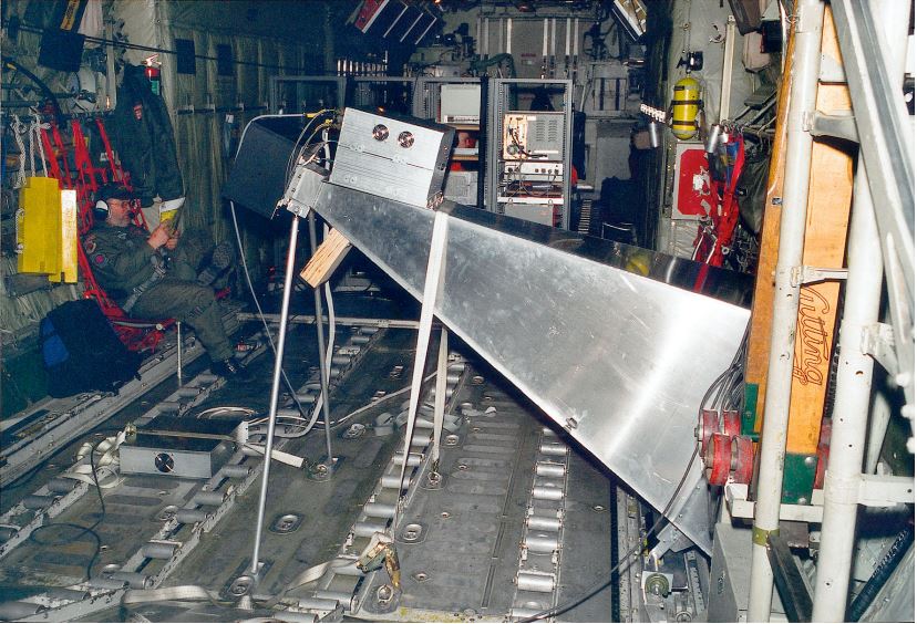
CoSMOS 2005, 2007, 2008, 2010
The Campaign for Validating the Operation of SMOS (coSMOS) was designed to acquire SMOS-like data so that the algorithms were fine-tuned and properly validated before the launch of SMOS mission in 2007.