- Data
- AVHRR Level-1B Local Area Cove...
AVHRR Level-1B Local Area Coverage Imagery
AVHRR L1B LAC
How to Access Data
EO Sign In Authentication (Open)
- Go to the Dissemination Service
- Find the product you want
- Register or log in to EO Sign In
- Download.
The products are also available for download via the following interface:
ESA EO Multimission Catalogue (EO CAT) - Allows users to discover and search products among the available datasets from ESA and Third Party Missions and instruments, using various criteria (spatial, temporal, specific).
New users can register an account on EO Sign In. For further information about the EO Sign In Service you can visit TellUs.
ESA internal users can use their ESAAD account.
Should you need support to access the data, please contact EOHelp.
Collection Description
This collection is composed of AVHRR L1B products (1.1 km) reprocessed from the NOAA POES and Metop AVHRR sensors data acquired at the University of Dundee and University of Bern ground stations and from the ESA and University of Bern data historical archive.
The product format is the NOAA AVHRR Level 1B that combines the AVHRR data from the HRPT stream with ancillary information like Earth location and calibration data which can be applied by the user. Other appended parameters are time codes, quality indicators, solar and satellite angles and telemetry.
Two data collections cover Europe and the neighbouring regions in the period of 1 January 1981 to 31 December 2020 and the acquired data in the context of the 1-KM project in the ‘90s.
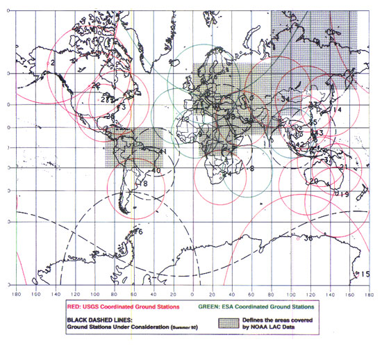
During the early 1990’s various groups, including the International Geosphere-Biosphere Programme (IGBP), the Commission of the European Communities (CEC), the Moderate Resolution Imaging Spectrometer (MODIS) Science Team and ESA concluded that a global land 1 KM AVHRR data set would have been crucial to study and develop algorithms for several land products for the Earth Observing System.
USGS, NOAA, ESA and other non-U.S. AVHRR receiving stations endorsed the initiative to collect a global land 1-km multi-temporal AVHRR data set over all land surfaces using NOAA's TIROS "afternoon" polar-orbiting satellite. On 1 April 1992, the project officially began up to the end of 1999 with the utilisation of 23 stations worldwide plus the NOAA local area coverage (LAC) on-board recorders. The global land 1-km AVHRR dataset is composed of 5 channels, raw AVHRR dataset at 1.1 km resolution from the NOAA-11 and NOAA-14 satellites covering land surfaces, inland water and coastal areas.
Spatial coverage: Check the spatial coverage of the collection on a map available on the Third Party Missions Dissemination Service:
Technical Details
DATA SET SPECIFICATIONS
- European Space Agency, 2020, AVHRR Level 1B European Data Set. Version 1.0.https://doi.org/10.5270/AVH-f1i8784
PROCESSING LEVEL
APPLICABLE TERMS & CONDITIONS
DATA CITATION
Resources
Discover Latest Data
Announcement of Opportunity for Spire data
ESA is launching an Announcement of Opportunity for the international scientific community to access data from the Spire mission for science...
ERS ATSR L1B Brightness Temperature/Radiance [ER1_AT_1_RBT / ER2_AT_1_RBT]
Band measurements with associated uncertainty estimates. The ERS-1/2 ATSR Level 1B Brightness Temperature/Radiance products (RBT) contain to...
TomoSense
The TomoSense experiment was conceived to provide the scientific community with unprecedented data to study the features of radar scattering...
WIVERNex-UK
This campaign was designed to extend the Chilbolton ground measurement record that involved analysis of radar observations made by the 94 GH...