- All Categories (41)
- Data (13)
- News (11)
- Missions (4)
- Events (9)
- Tools (1)
- Campaigns (3)
Event - Training

10th Advanced Training Course on Land Remote Sensing EO and AI for Forestry
This ESA course was dedicated to training the next generation of EO scientists and experts working in forestry domain to exploit data from EO missions and use AI for science and applications development.
Event - Conference

15 Years of Progress in Radar Altimetry Symposium
A Symposium on "15 Years of Progress in Radar Altimetry" and the annual meeting of the Ocean Surface Topography Science Team, the International Doris Service Workshop and the ARGO Workshop.
Event - Workshop

2nd International GOCE User Workshop
This workshop provided a forum for presenting progress on the development of the GOCE mission's payload, ground segment and data products.
Event - Workshop
3rd International GOCE User Workshop
This workshop focussed on the oceanographic applications, such as absolute dynamic topography, of GOCE data in conjunction with other space-borne data, such as radar altimetry, and in-situ data and models.
Data - Campaigns (Open)

AfriSAR 2016
In order to further support the BIOMASS mission development, especially concerning the mission concept verification and the development of geophysical algorithms, ESA funded the AfriSAR campaign.
News - Spotlight on EO community
An overview of the Biomass mission
In this video, Klaus Scipal - Biomass and SMOS Mission Manager - talks about ESA's upcoming Biomass mission.
Data - Announcement of Opportunity (Restrained)

Announcement of Opportunity for NoR
ESA invites submissions for the Network of Resources (NoR) call, which aims to support research, development and pre-commercial users to innovate their working practices, moving from a data download paradigm towards a 'bring the user to the data' paradigm.
Data - Announcement of Opportunity (Restrained)
Announcement of Opportunity for NovaSAR-1
ESA is launching an Announcement of Opportunity for the international scientific community to access data from the NovaSAR-1 mission for science and EO-based applications development.
Mission - Earth Explorers
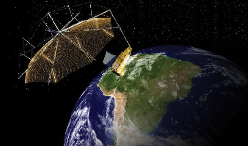
Biomass
The objective of the Biomass mission is to determine the global distribution of forest biomass.
Campaign

BioSAR 2007
The BioSAR campaign aimed to support geophysical algorithm development, calibration/validation and the simulation of future spaceborne Earth Observation missions.
Data - Campaigns (Open)
BioSAR 2007
The BioSAR campaign aimed to support geophysical algorithm development, calibration/validation and the simulation of future spaceborne Earth Observation missions.
Campaign

BioSAR 2008
The main objective of BioSAR-2 (BioSAR 2008) campaign was to record SAR data over boreal forests with topographic effects to investigate the effect on biomass retrieval.
Data - Campaigns (Open)
BioSAR 2008
The main objective of BioSAR-2 (BioSAR 2008) campaign was to record SAR data over boreal forests with topographic effects to investigate the effect on biomass retrieval.
Campaign

BioSAR 2010
The BioSAR-3 (BioSAR 2010) campaign was specifically planned and implemented to investigate possibilities for a future spaceborne P-band polarimetric and interferometric SAR with a life-time of multiple years.
Event - Workshop
BRIX-I: Workshop of First Biomass Retrieval Algorithm Inter-comparison Exercise
BRIX-I: Workshop of First Biomass Retrieval Algorithm Inter-comparison Exercise
Mission - Third Party Missions

COSMO-SkyMed Second Generation
COSMO-SkyMed Second Generation is at the forefront of radar technology, will ensure improvements and guarantee continuity with the First Generation CSK satellites, preserving the high quality and the highest precision features, both required for the interferometric activities.
Event - Workshop
CryoSat 2005 Workshop
The workshop provided new and familiar users of the mission with a detailed understanding of the mission status and projected performance at launch, and provided the first presentation to users of the processing algorithms.
News - Success Stories

Drone-based Laser Scanning of Tropical Forests for Biomass Cal/Val
ESA’s upcoming mission Biomass will deliver valuable P-band SAR data aimed at forest aboveground biomass (AGB) estimation across the humid tropics.
Data - Fast Registration with immediate access (Open)

ERS PRARE Precise Orbit Product (ERS.ORB.POD/ERS.ORB/PRC)
The precise orbit results from a data reduction process in which all available tracking data (Single-Lens Reflex, radar altimeter crossovers, PRARE range and Doppler data) and most accurate correction, transformation and dynamical models are taken into account and in which high level numerical procedures are applied. These orbits are "optimal" achievable representations of the real orbital motion under the circumstances of tracking situation and the "state of the art" model situation. The precise orbit product for the ERS satellites are the satellite ephemeris (position and velocity vector) including time tag, given in a well-defined reference frame, together with the nominal satellite attitude information and a radial orbit correction. Several orbit solutions are currently distributed: A new set of ORB POD (Precise Orbit Determination - REAPER v2) computed with the most updated model standards for the complete ERS-1 and ERS-2 mission. A previous set of ORB POD (REAPER v1) data already available on the ESA dissemination site since 2014, covering the ERS-1 full mission and the ERS-2 mission up to July 2003. ORB PRC which is the original Precise Orbit dataset computed during the ERS mission operations for ERS-1 and ERS-2. In the new POD dataset (REAPER v2) for the ERS-1 and ERS-2 missions, two different orbit solutions are provided together with the combined solution to be used for processing of the radar altimeter measurements and the determination of geodetic/geophysical products: those computed by DEOS (Delft Institute of Earth Observation and Space Systems), and those generated by ESOC (European Space Operations Centre) using different software (GEODYN and NAPEOS respectively). Careful evaluation of the various solutions of REAPER v2 has shown that the DEOS solution for both ERS-1 and ERS-2 has the best performance and is recommended to be used as reference. See the ERS Orbit Validation Report. For the previous version of the POD data set (REAPER v1), with ERS-2 mission data only up to 2003, three different orbit solutions together with the combined solution are available. These precise orbits for ERS-1 and ERS-2 have been computed at DEOS, ESOC, and GFZ (Deutschen GeoForschungsZentrums) using different software and different altimeter databases. Combined solutions have been created using three individual solutions for each satellite. All orbits were derived using consistent models in the same LPOD2005 terrestrial reference frame. These new orbit solutions show notable improvement with respect to DGME04 orbits (Scharroo and Visser, 1998). Thus, RMS crossover differences of new orbits improved by 4-9 mm. Careful evaluation of the various solutions has shown that the combined solution for both ERS-1 and ERS-2 has the best performance. All POD orbit files (REAPER v1/v2) are available in SP3c format.
News - Announcement of Opportunity updates
ESA encourages S-band applications with NovaSAR-1 Announcement of Opportunity
ESA is offering possibilities to develop new applications in the S-band microwave frequency range, with a new Announcement of Opportunity for NovaSAR-1 data, via ESA’s Third Party Mission programme.