- All Categories (19)
- Data (3)
- News (6)
- Events (9)
- Activities (1)
News - Data Release news
Envisat MIPAS data now available on new ESA Dissemination Server
The latest reprocessed Envisat MIPAS Level 1 and Level 2 datasets have now been migrated from simple FTP access to the new Online Dissemination service for ESA Heritage Missions (HM) Atmospheric data.
News - Infographics
Showcasing the atmosphere-studying Odin mission
Learn about the Odin mission in our new infographic.
News - Success Stories

Atmosphere-studying Odin mission enjoys ongoing success
More than two decades after it began operations, the Odin remote sensing satellite is continuing to make strong contributions to high-impact atmospheric science.
Activity - General activities
EO Summer Schools
ESA's series of summer schools, on Monitoring of the Earth System, aims to promote the exploitation of Earth observation (EO) data.
News - Success Stories

Satellites track the health of the ozone layer
ESA’s Earth observation activities are contributing to international efforts to monitor and preserve the layer of stratospheric ozone that blankets the planet.
Event - Training

EO Summer School 8
ESA's series of summer schools, on Monitoring of the Earth System, aims to promote the exploitation of Earth observation data.
Event - Training
EO Summer School 7
ESA's series of summer schools, on Monitoring of the Earth System, aims to promote the exploitation of Earth observation data.
Event - Training
EO Summer School 6
ESA's series of summer schools, on Monitoring of the Earth System, aims to promote the exploitation of Earth observation data.
Event - Training
EO Summer School 5
ESA's series of summer schools, on Monitoring of the Earth System, aims to promote the exploitation of Earth observation data.
Event - Training
EO Summer School 4
ESA's series of summer schools, on Monitoring of the Earth System, aims to promote the exploitation of Earth observation data.
Event - Training
EO Summer School 3
ESA's series of summer schools, on Monitoring of the Earth System, aims to promote the exploitation of Earth observation data.
Event - Training
EO Summer School 2
ESA's series of summer schools on Monitoring of the Earth System, aims to promote the exploitation of Earth observation data.
Event - Training
EO Summer School 1
ESA's series of summer schools, on Monitoring of the Earth System, aims to promote the exploitation of Earth observation data.
Event - Conference

Atmospheric Science Conference 2006
The 2006 conference was dedicated the theme atmosphere to provide scientists and data users with the opportunity to present first-hand and up-to-date results from their ongoing research activities ESA Mission instruments.
News - Data Release news
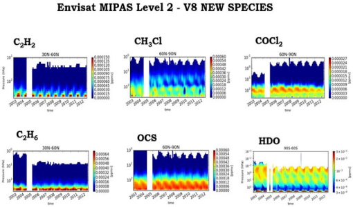
New Envisat MIPAS L2 dataset reprocessed with ORM v8.22 available
The Level 2 reprocessing of the full Envisat MIPAS mission with the ESA ORM processor version 8.22 has been completed.
Data - Data Description
Odin SMR data products
The latest Odin Sub-Millimetre Radiometer (SMR) datasets have been generated by Chalmers University of Technology and Molflow within the Odin-SMR Recalibration and Harmonisation project, funded by the European Space Agency (ESA) to create a fully consistent and homogeneous dataset from the 20 years of satellite operations. The Odin satellite was launched in February 2001 as a joint undertaking between Sweden, Canada, France and Finland, and is part of the ESA Third Party Missions (TPM) programme since 2007. The complete Odin-SMR data archive was reprocessed applying a revised calibration scheme and upgraded algorithms. The Level 1b dataset is entirely reconsolidated, while Level 2 products are regenerated for the main mesospheric and stratospheric frequency modes (i.e., FM 01, 02, 08, 13, 14, 19, 21, 22, 24). The resulting dataset represents the first full-mission reprocessing campaign of the mission, which is still in operation.
News - Infographics

Envisat - ESA's versatile Earth observation satellite
Learn more about ESA's Envisat mission - the largest Earth observation satellite ever built - in a new infographic.
Data - EO Sign In Authentication (Open)

Envisat MIPAS L1 - Geo-located and calibrated atmospheric spectra [MIP_NL__1P]
This MIPAS Level 1 data product covers the geo-located, spectrally and radiometrically calibrated limb emission spectra in the 685-2410 cm-1 wave number range. It comprises 5 bands: 685-980 cm-1, 1010-1180 cm-1, 1205-1510 cm-1, 1560-1760 cm-1, 1810-2410 cm-1 and covers the following spatial ranges: Tangent height range: 5 to 170 km Pointing range: (azimuth pointing range relative to satellite velocity vector): 160° - 195° (rearward anti-flight direction); 80° - 110° (sideward anti-Sun direction). The instantaneous field of view (IFOV) is 0.05230 (elevation) x 0.5230 (azimuth)°. The length of measurement cell for an individual height step is approximately 300-500 km (dependent on tangent height and optical properties of the atmosphere). The spectral resolution spans from 0.030 to 0.035 cm-1, with a radiometric sensitivity of 4.2 to 50 nW / cm-1 / sr / cm2. The resolution range of the dataset is: 3 km (vertical) x 30 km (horizontal) at the tangent point. Please consult the Product Quality Readme file for MIPAS Level 1b IPF 8.03 before using the data.
Data - EO Sign In Authentication (Open)
Envisat MIPAS L2 - Temperature, pressure and atmospheric constituents profiles [MIPAS_2PS/2PE]
This MIPAS Level 2 data product describes localised vertical profiles of pressure, temperature and 21 target species (H2O, O3, HNO3, CH4, N2O, NO2, CFC-11, ClONO2, N2O5, CFC-12, COF2, CCL4, HCN, CFC-14, HCFC-22, C2H2, C2H6, COCl2, CH3Cl, OCS and HDO). It has a global coverage of Earth's stratosphere and mesosphere at all latitudes and longitudes. The vertical resolution of p, T and VMR profiles varies from 3 to 4 km, whereas the horizontal resolution is approximately 300 km to 500 km along track. This depends on the tangent height range and optical properties of the atmosphere. Auxiliary data include spectroscopic data, microwindows data, validation data, initial guess p, T and trace gas VMR profiles. The resolution range of the dataset is: 3 km (vertical) x 30 km (horizontal) at the tangent point. The latest reprocessed MIPAS Level 2 data (v8.22) is available as Standard products (MIPAS_2PS): A complete product containing 22 MIPAS L2 chemical species covering a single orbit and single species providing information generally needed by data users. Extended products (MIPAS_2PE): A complete product containing 22 MIPAS L2 chemical species covering a single orbit and single species intended for diagnostics and expert users who need complete information about the retrieval process. Both products are available in NetCDF format. Please refer to the MIPAS L2 v8.22 Product Quality Readme file for further details.