- All Categories (14)
- Data (2)
- News (10)
- Missions (1)
- Events (1)
News - Events and Proceedings
EarthCARE pre-launch science workshop a success
Held between 13 and 17 November 2023, in ESA’s Earth Observation facility in Frascati, Italy, the ESA-JAXA pre-launch EarthCARE science and validation workshop brought together nearly 250 participants, representing a vibrant worldwide scientific community that is eagerly awaiting the mission’s launch.
News - Spotlight on EO community
An overview of the EarthCARE mission
In this video, meet Björn Frommknecht, Mission Manager of ESA's upcoming EarthCARE satellite.
News - Spotlight on EO community
Introducing the EarthCARE Mission Manager
In this video, Björn Frommknecht describes his role as Mission Manager of EarthCARE, and what he enjoys most about his involvement with this upcoming Earth Explorer.
News - Events and Proceedings
Last call for EarthCARE workshop abstracts
The abstract submission deadline for the EarthCARE Pre-Launch Science and Validation Workshop is just a week away. If you would like to present your work at the workshop, submit your abstract by 10 July.
News - Events and Proceedings
Submit your abstracts for EarthCARE Pre-Launch Science and Validation Workshop
Invitations are now open for the EarthCARE Pre-Launch Science and Validation Workshop, which will take place at ESRIN in Frascati, Italy, from 13 to 17 November.
Event - Workshop

EarthCARE pre-launch science and validation workshop
The EarthCARE pre-launch Science and Validation Workshop will bring together the community to discuss the science of this upcoming cloud and aerosol mission, and offer the opportunity to discuss validation activities.
News - Infographics

EarthCARE - ESA's cloud, aerosol and radiation explorer mission
Learn about ESA’s upcoming cloud, aerosol and radiation explorer mission – EarthCARE – in our latest infographic.
News - Events and Proceedings

Highlights from Living Planet Symposium
As remote sensing scientists and data-users from around the world converged at the Living Planet Symposium (LPS) in Bonn recently, a common thread was evident in many scientific sessions and meetings – the right environmental data can accelerate our understanding of the rapid changes in Earth’s system.
News - Events and Proceedings

Data preservation takes centre stage at Living Planet Symposium
Against the backdrop of the famed Rhine River, world-class scientists and Earth observation data-users are gathered this week in the historical city of Bonn, at the Living Planet Symposium (LPS).
News - Success Stories

How Envisat helped to shape global understanding of Earth’s systems
Twenty years have passed since a ground-breaking European spacecraft designed to deliver unprecedented insight into the planet’s changing environment was lofted into orbit.
News - Data Release news
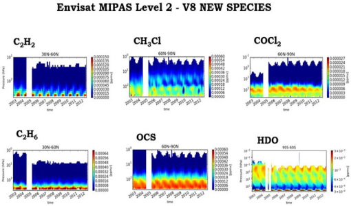
New Envisat MIPAS L2 dataset reprocessed with ORM v8.22 available
The Level 2 reprocessing of the full Envisat MIPAS mission with the ESA ORM processor version 8.22 has been completed.
Data - EO Sign In Authentication (Open)

Envisat MIPAS L1 - Geo-located and calibrated atmospheric spectra [MIP_NL__1P]
This MIPAS Level 1 data product covers the geo-located, spectrally and radiometrically calibrated limb emission spectra in the 685-2410 cm-1 wave number range. It comprises 5 bands: 685-980 cm-1, 1010-1180 cm-1, 1205-1510 cm-1, 1560-1760 cm-1, 1810-2410 cm-1 and covers the following spatial ranges: Tangent height range: 5 to 170 km Pointing range: (azimuth pointing range relative to satellite velocity vector): 160° - 195° (rearward anti-flight direction); 80° - 110° (sideward anti-Sun direction). The instantaneous field of view (IFOV) is 0.05230 (elevation) x 0.5230 (azimuth)°. The length of measurement cell for an individual height step is approximately 300-500 km (dependent on tangent height and optical properties of the atmosphere). The spectral resolution spans from 0.030 to 0.035 cm-1, with a radiometric sensitivity of 4.2 to 50 nW / cm-1 / sr / cm2. The resolution range of the dataset is: 3 km (vertical) x 30 km (horizontal) at the tangent point. Please consult the Product Quality Readme file for MIPAS Level 1b IPF 8.03 before using the data.
Data - EO Sign In Authentication (Open)
Envisat MIPAS L2 - Temperature, pressure and atmospheric constituents profiles [MIPAS_2PS/2PE]
This MIPAS Level 2 data product describes localised vertical profiles of pressure, temperature and 21 target species (H2O, O3, HNO3, CH4, N2O, NO2, CFC-11, ClONO2, N2O5, CFC-12, COF2, CCL4, HCN, CFC-14, HCFC-22, C2H2, C2H6, COCl2, CH3Cl, OCS and HDO). It has a global coverage of Earth's stratosphere and mesosphere at all latitudes and longitudes. The vertical resolution of p, T and VMR profiles varies from 3 to 4 km, whereas the horizontal resolution is approximately 300 km to 500 km along track. This depends on the tangent height range and optical properties of the atmosphere. Auxiliary data include spectroscopic data, microwindows data, validation data, initial guess p, T and trace gas VMR profiles. The resolution range of the dataset is: 3 km (vertical) x 30 km (horizontal) at the tangent point. The latest reprocessed MIPAS Level 2 data (v8.22) is available as Standard products (MIPAS_2PS): A complete product containing 22 MIPAS L2 chemical species covering a single orbit and single species providing information generally needed by data users. Extended products (MIPAS_2PE): A complete product containing 22 MIPAS L2 chemical species covering a single orbit and single species intended for diagnostics and expert users who need complete information about the retrieval process. Both products are available in NetCDF format. Please refer to the MIPAS L2 v8.22 Product Quality Readme file for further details.
Mission - Heritage Missions

Envisat
Envisat was ESA's successor to ERS. Envisat carried ten instruments aboard for a wide range of Earth observing fields. The mission was operational from 2002 to 2012.