- All Categories (24636)
- Data (46)
- News (328)
- Missions (4)
- Events (47)
- Tools (28)
- Activities (44)
- Campaigns (27)
- Documents (24112)
DATA
Discover and download the Earth observation data you need from the broad catalogue of missions the European Space Agency operate and support.
Data - Sample Data (Open)

CryoSat Data Samples
Download CryoSat data samples from Baseline-B, C, and D products.
Data - Data Description
Aeolus Level 2C assisted wind fields resulting from NWP (Numerical Weather Prediction) assimilation processing
The Level 2C wind product of the Aeolus mission provides ECMWF analysis horizontal wind vectors at the geolocations of assimilated L2B HLOS wind components. The L2C can therefore be described as an Aeolus-assisted horizontal wind vector product. The L2C is a distinct product, however the L2C and L2B share a common Earth Explorer file template, with the L2C being a superset of the L2B. The L2C consists of extra datasets appended to the L2B product with information which are relevant to the data assimilation of the L2B winds.
Data - EO Sign In Authentication (Open)
Aeolus L2A Aerosol/Cloud optical product
The Level 2A aerosol/cloud optical products of the Aeolus mission include: Geo-located consolidated backscatter and extinction profiles Backscatter-to-extinction coefficient LIDAR ratio, scene classification Heterogeneity index Attenuated backscatter signals. Resolution: Horizontal resolution of L2A optical properties at observation scale (~87 km); Exceptions are group properties (horizontal accumulation of measurements from ~3 km to ~87 km) and attenuated backscatters (~3 km). Note: The resolution of "groups" in the L2A can only go down to 5 measurements at the moment, i.e. ~15 km horizontal resolution. This could be configured to go to 1 measurement - Vertical resolution 250-2000 m (Defined by Range Bin Settings).
Data - Announcement of Opportunity (Restrained)

Announcement of Opportunity for Aeolus Cal/Val
An Announcement of Opportunity call is open for the Aeolus mission. Scientists, new groups and individuals are invited to participate in Aeolus Cal/Val throughout the mission lifetime.
Data - EO Sign In Authentication (Open)
Aeolus Scientific L2B Rayleigh/Mie wind product
The Level 2B wind product of the Aeolus mission is a geo-located consolidated HLOS (horizontal line-of-sight) wind observation with actual atmospheric correction applied to Rayleigh channel. The product is generated within 3 hours after data acquisition.
Data - EO Sign In Authentication (Open)
Aeolus preliminary HLOS (horizontal line-of-sight) wind observations for Rayleigh and Mie receivers
The Level 1B wind product of the Aeolus mission contains the preliminary HLOS (horizontal line-of-sight) wind observations for Rayleigh and Mie receivers, which are generated in Near Real Time. Standard atmospheric correction (Rayleigh channel), receiver response and bias correction is applied. The product is generated within 3 hours after data acquisition.
Data - Campaigns (Open)
CryoVExGround 2011
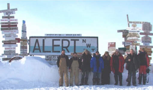
The aims of the CryoVEx 2011 experiment, operating out of Alert base, was to study the snow and ice characteristics of Arctic sea ice and its snow cover during winter.
Data - Campaigns (Open)
CryoVExAnt 2014/2015
The aim of CryoVEx Ant 2014 to 2015 was to perform altimeter measurements at a designated validation site in the vicinity of the Schirmacher Oasis, near Kohnen and Neumayer as well as in the Pine Island Glacier drainage basin.
Data - Campaigns (Open)

CryoVExAnt 2010/2011
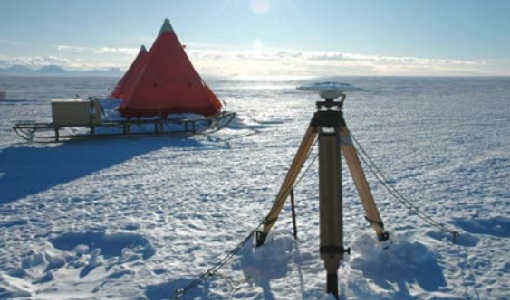
The CryoVEx 2010/2011 Antartic campaign was carried out in Dronning Maud Land from 11 November 2010 to 20 February 2011.
Data - Campaigns (Open)
CryoVExAnt 2008/2009
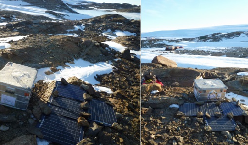
The key objective of the CryoSat Validation Experiment Antarctica (CryoVExAnt) campaign is a better approximation of the error range of the elevation obtained from SAR-processed altimetric radar returns and its sensitivity to surface roughness.
Data - Open access (Open)

Swarm Level 1B
The Level 1b products of the Swarm mission contains time-series of quality-screen, calibrated, and corrected measurements given in physical, SI units in geo-localized reference frames. Level 1b products are provided individually for each of the three satellites Swarm A, Swarm B, and Swarm C on a daily basis.
Data - Open access (Open)

Swarm Geodesy/Gravity
Monthly gravity field of the Earth, non-gravitational accelerations.
Data - Open access (Open)
Swarm Ionosphere/Magnetosphere
Spherical harmonic model of the large-scale magnetospheric field and its Earth-induced counterpart, spherical harmonic model of the daily geomagnetic variation at middle latitudes and low latitudes, Ionospheric bubble index, ionospheric total electron content, ionosphericfield-aligned currents, dayside ionospheric equatorial electric field, ionospheric plasma density and plasma irregularities.
Data - Open access (Open)
Swarm Level 2 daily
The Swarm Level 1b data products are the corrected and formatted output from each of the three Swarm satellites. By a complex assimilation of these individual satellite measurements into one set of products for the satellite constellation, the Swarm Level 2 Processor ensures a very significant improvement of the quality of the final scientific data products.
Data - Open access (Open)
Swarm Core
Spherical harmonic model of the main (core) field and its temporal variation.
Data - Open access (Open)
Swarm Space Weather
Environmental conditions in Earth's magnetosphere, ionosphere and thermosphere due to the solar activity that drive the Sun-Earth interactions.
