- Campaigns
- CryoVExAnt 2010/2011
CryoVExAnt 2010/2011
Overview
What was the purpose of CryoVExAnt 2010 and 2011?
Following the successful CryoSat Validation Experiment Antarctica (CryoVExAnt) 2008/2009 campaign, the CryoVExAnt 2010/2011 campaign was carried out in Dronning Maud Land from 11 November 2010 to 20 February 2011.
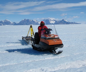
Airborne and ground measurements were recorded in this campaign, which was the second CryoSat Cal/Val experiment supported by ESA in Antarctica. Both airborne and ground measurements were performed in the blue ice region close to Novolazarevskaya-Airbase and were carried out by scientists from TU Dresden and AWI.
The key objective of the ground measurements was to provide precise ground-based information on ice surface heights in the area of investigation. To obtain surface height changes it was essential to repeat the test areas observed during CryoVExAnt 2008/2009 campaign within the blue ice region.
What was the outcome of CryoVExAnt 2010 and 2011?
In general, the ground and airborne activities were very successful. All planned survey lines, including the survey test grids, could be measured.
Download the CryoVExAnt 2010 and 2011 Final Report
| Data Coverage (Years) | 2010-2011 |
| Geographic Site | Antarctic |
| Field of Application | Kinematic GNSS surface height and snow thickness |
Digital Object Identifier: https://doi.org/10.5270/esa-1vvc63g - CryoVExAnt 2010 and 2011: "Technical Assistance during the 2010/2011 CryoSat Shirmaheroase Antartic Validation Activity"
Data
The campaign data is available online via FTPS upon submission of a data access request. An active EO Sign In account is required to submit the request.
The data can be downloaded via an FTP client (e.g., FileZilla or WinSCP) using the option "Implicit FTP over TLS".
Data from the campaign are also available to download from the CS2EO portal.
For further information about the EO Sign In Service you can visit TellUs
Should you need support please contact EOHelp