- All Categories (9975)
- Data (8)
- News (19)
- Missions (4)
- Events (15)
- Tools (1)
- Activities (14)
- Campaigns (3)
- Documents (9911)
Activity - Projects
ESA's multi-level global thermosphere data products consistent with Swarm and GRACE (-FO)
In this project, the possibility of using the space-based along-track Thermospheric Neutral Density (TND) estimates for generating the European Space Agency (ESA)'s Level 3 (L3) global multi-level TND data products is assessed.
Activity - Projects

Swarm Ionospheric Polar Electrodynamics
The goal of the Swarm ionospheric polar electrodynamics (SWIPE) project is to create and disseminate the most advanced models of high-latitude Joule dissipation, ionospheric convection, and ionospheric conductances.
Data - Announcement of Opportunity (Restrained)

Announcement of Opportunity for S3VT (Sentinel-3 Validation Team)
In the framework of a Copernicus collaborative agreement ESA and EUMETSAT invite interested groups and individuals to support the Sentinel-3 Validation Team (S3VT).
News - Success Stories

Drones join the campaign to validate Aeolus data
In June and September 2022, the Askos component of the Joint Aeolus Tropical Atlantic Campaign (JATAC), organised by ESA and its international partners, was expanded with new ground-based, drone and radiosonde measurements. The main objective of this campaign was to calibrate and validate Aeolus satellite observations.
Activity - Projects
Swarm Ion Temperature Estimation
The main objective of Swarm Ion Temperature Estimation (SITE) project is to estimate ion temperatures along the orbits of Swarm satellites using available LP electron density and temperature measurements, and numerical models.
Activity - Projects

Swarm LP Ion Drift and Effective Mass
The Swarm LP Ion Drift and Effective Mass (SLIDEM) project will augment Swarm's ability to measure the along-track component of ion drift, and assess the composition of ionospheric ions.
Activity - Projects
Plasmapause Related boundaries in the topside Ionosphere as derived from Swarm Measurements
In the project, Plasmapause Related boundaries in the topside Ionosphere as determined from Swarm Measurements (PRISM), the team develop products that characterise position of the plasmapause related phenomena in the topside ionosphere.
Activity - Projects
ESC Geomagnetic Conditions
The objective of the Expert Service Centre Geomagnetic Conditions - definition and development activities work is to ensure operational and development activities within the Geomagnetic Conditions Expert Service Centre of ESA's Space Situational Awareness Space Weather network.
Activity - Projects

Contribution of Swarm data to the prompt detection of Tsunamis and other natural hazards
The main objective of COSTO (Contribution of Swarm data to the prompt detection of Tsunamis and other natural hazards) project is to better characterise, understand and discover coupling processes and interactions.
News - Thematic area articles

Space data help to unravel the complexities of Earth’s atmosphere
As the impacts of the climate crisis intensify, scientists are using ESA’s Earth observation archives to investigate atmospheric processes and their influences on the planet’s changing environment.
News - Events and Proceedings

Exploring the prevailing achievements and future directions of Aeolus
A tight-knit community of European remote sensing experts converged on the Italian island of Sicily last month to discuss how the strong success of ESA’s Aeolus mission is shaping scientists’ understanding of the winds that sweep across the planet.
Tools - Processing
Aeolus VRE
The Aeolus Virtual Research Environment (VRE) is the latest extension to the VirES for Aeolus service, which offers more direct and in-depth data exploitation of the Aeolus mission. The VRE is a cloud service that provides a web-based development environment in the form of a JupyterLab workspace.
News - General News

Launch of Aeolus VRE
The Aeolus Virtual Research Environment (VRE) is a cloud service, which provides users with a web-based development environment in the form of a JupyterLab workspace.
News - Success Stories

How Envisat helped to shape global understanding of Earth’s systems
Twenty years have passed since a ground-breaking European spacecraft designed to deliver unprecedented insight into the planet’s changing environment was lofted into orbit.
News - Success Stories

Dust aerosol campaign validates Aeolus data
Prepared, implemented and executed by a consortium of French universities and research institutions, under the umbrella of the French Space Agency (CNES) and the French National Centre for Scientific Research (CNRS), the Clouds-Atmospheric Dynamics–Dust Interactions in West Africa (CADDIWA) campaign took place on Sal Island in Cape Verde, from 6 to 25 September 2021.
News - Spotlight on EO community
Meet ESA's Swarm Mission Manager
Anja Strømme, ESA's Swarm Mission Manager, describes in detail the wonders of the Swarm mission.
News - Data Release news
New Swarm Ion Temperature Estimation (SITE) data product released
A new dataset of Swarm Ion Temperature Estimation (SITE) is now available for the three Swarm spacecraft.
Document - General Reference

spaceborne-radar-applications-in-geology-an-introduction.pdf
This document is intended for geologists who are interested in broadening their knowledge of interpretation of imaging radar data. It introduces imaging radar as it may be used by technicians and image interpreters. Interferometric SAR is briefly treated, with some basic and practical hints. An illustrated application study on land subsidence is included.
Document - Software Verification Plan/Report

GUT2-Final-Project-Report.pdf
This document is the Final Report of the project carried out by a consortium led by DTU, "GUTS Phase 3" Development and Supporting Scientific Studies" in response to Statement of Work XGCE, DTEX, EOPSSW & 090001.
News - Infographics
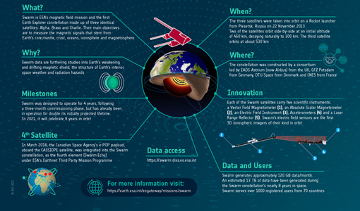
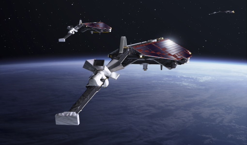
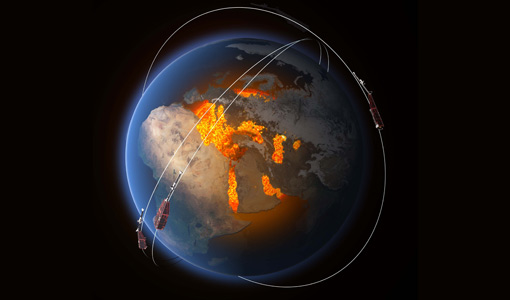
Swarm - ESA's magnetic field satellite mission
Learn more about ESA's Swarm mission, an Earth Explorer dedicated to studying Earth's magnetic field, in our latest infographic.