- PAZ
- Mission
- PAZ Objectives
PAZ Objectives
The PAZ mission is able to support a wide number of applications, including:
- Border control
- Intelligence
- Environmental monitoring
- Protection of natural resources
- Military operations
- Enforcement of international treaties
- Surface monitoring
- City and infrastructure planning
- Monitoring of natural catastrophes and high-resolution mapping
Featured Images
See a collection of images acquired by the PAZ satellite over a variety of locations, which demonstrate the different modes the mission provides and applications PAZ supports.
View full image
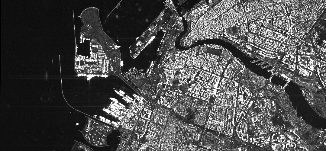
La Palma, Canary Islands - PAZ takes us over La Palma, Canary Islands, with this StripMap (SM) image, acquired on 19 October 2021 at 19:13 UTC. Copyright: PAZ satellite image @ Hisdesat Servicios Estratégicos S.A. 2021
La Palma, Canary Islands - PAZ takes us over La Palma, Canary Islands, with this StripMap (SM) image, acquired on 19 October 2021 at 19:13 UTC. Copyright: PAZ satellite image @ Hisdesat Servicios Estratégicos S.A. 2021
View full image
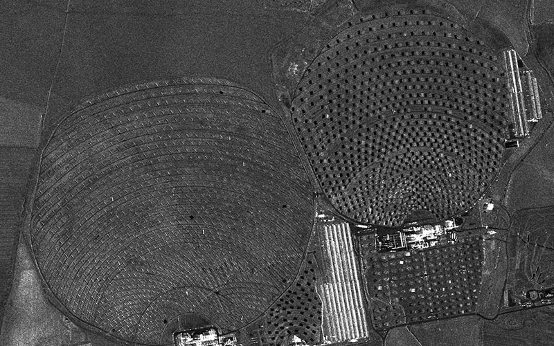
Solar Plant in Seville, Spain - PAZ takes us over a Solar Plant in Seville, Spain, with this Staring SpotLight (ST) image, acquired on 4 February 2021 at 06:38 UTC. Copyright: PAZ satellite image @ Hisdesat Servicios Estratégicos S.A. 2021
Solar Plant in Seville, Spain - PAZ takes us over a Solar Plant in Seville, Spain, with this Staring SpotLight (ST) image, acquired on 4 February 2021 at 06:38 UTC. Copyright: PAZ satellite image @ Hisdesat Servicios Estratégicos S.A. 2021
View full image
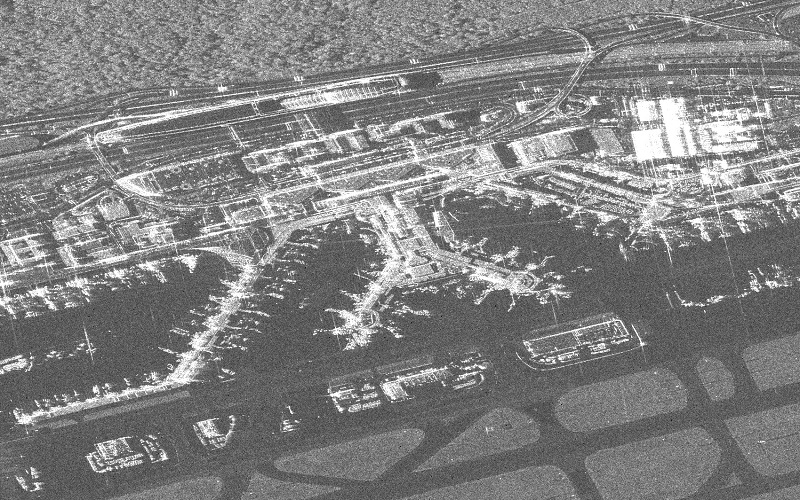
Frankfurt Airport, Germany - PAZ takes us over Frankfurt Airport, Germany, with this High Resolution SpotLight (HS) image, acquired on 18 June 2020 at 17:17 UTC. Copyright: PAZ satellite image @ Hisdesat Servicios Estratégicos S.A. 2020
Frankfurt Airport, Germany - PAZ takes us over Frankfurt Airport, Germany, with this High Resolution SpotLight (HS) image, acquired on 18 June 2020 at 17:17 UTC. Copyright: PAZ satellite image @ Hisdesat Servicios Estratégicos S.A. 2020
View full image
Absheron Peninsula, Caspian Sea - This PAZ image was acquired in ScanSAR image mode on 23 July 2019 and shows the Absheron Peninsula on the coast of the Caspian Sea. We can see Pirallahi and Chilov islands just off the coast of the peninsula and the many oil and gas fields that extend through the shallow waters of the Caspian Sea in this area. Copyright: PAZ satellite image © Hisdesat Servicios Estratégicos S.A. 2019
Absheron Peninsula, Caspian Sea - This PAZ image was acquired in ScanSAR image mode on 23 July 2019 and shows the Absheron Peninsula on the coast of the Caspian Sea. We can see Pirallahi and Chilov islands just off the coast of the peninsula and the many oil and gas fields that extend through the shallow waters of the Caspian Sea in this area. Copyright: PAZ satellite image © Hisdesat Servicios Estratégicos S.A. 2019
View full image
Dubai, United Arab Emirates - This PAZ image was acquired in SpotLight image mode on 9 June 2019 and shows the city of Dubai in the United Arab Emirates. We can see Port Rashid at the top of the image, where Dubai Creek reaches the Persian Gulf. Along the coastline, we can see south of the port a few of the smaller artificial islands that have been constructed using land reclamation, including Pearl Jumeirah and Daria Island. Copyright: PAZ satellite image © Hisdesat Servicios Estratégicos S.A. 2019
Dubai, United Arab Emirates - This PAZ image was acquired in SpotLight image mode on 9 June 2019 and shows the city of Dubai in the United Arab Emirates. We can see Port Rashid at the top of the image, where Dubai Creek reaches the Persian Gulf. Along the coastline, we can see south of the port a few of the smaller artificial islands that have been constructed using land reclamation, including Pearl Jumeirah and Daria Island. Copyright: PAZ satellite image © Hisdesat Servicios Estratégicos S.A. 2019
View full image
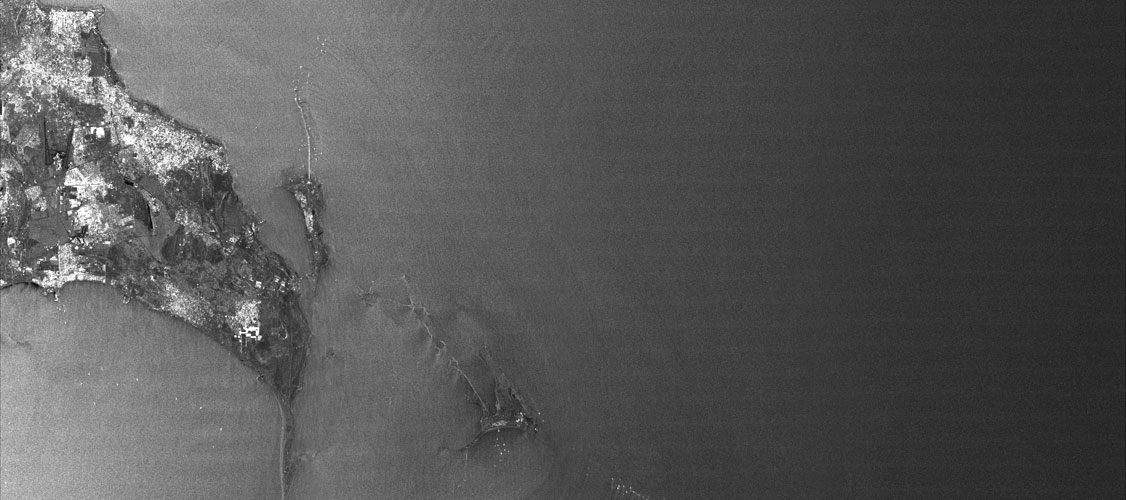
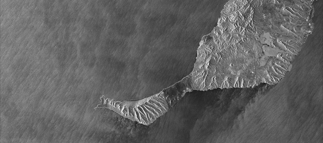
Fuerteventura, Canary Islands - This PAZ image was acquired in ScanSAR image mode on 8 March 2019 and shows Fuerteventura, one of the Canary Islands. We can see the Jandia Peninsula at the south end of the island, much of which is a nature reserve. The radar imagery clearly reveals the characteristic mountainous terrain of the island. Copyright: PAZ satellite image © Hisdesat Servicios Estratégicos S.A. 2019
Fuerteventura, Canary Islands - This PAZ image was acquired in ScanSAR image mode on 8 March 2019 and shows Fuerteventura, one of the Canary Islands. We can see the Jandia Peninsula at the south end of the island, much of which is a nature reserve. The radar imagery clearly reveals the characteristic mountainous terrain of the island. Copyright: PAZ satellite image © Hisdesat Servicios Estratégicos S.A. 2019
View full image
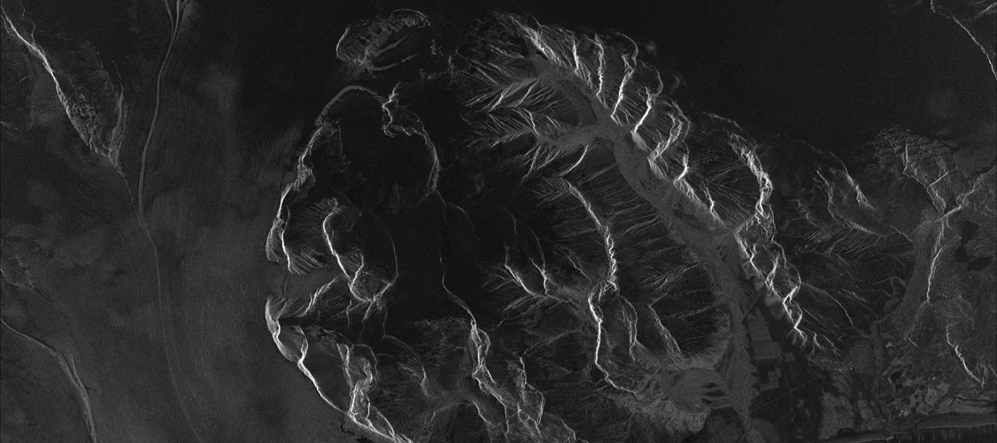
Vatnajökull ice cap, Iceland - This PAZ image was acquired in StripMap image mode on 15 May 2019 and shows a glacier at the edge of the Vatnajökull ice cap in Iceland. Vatnajökull is the largest ice cap on the island, and sits on the south-east of Iceland. In the full image, the black areas to the south of the glacier are bodies of water, including the Jökulsárlón Lake and at the bottom of the image, the Atlantic Ocean. Copyright: PAZ satellite image © Hisdesat Servicios Estratégicos S.A. 2019
Vatnajökull ice cap, Iceland - This PAZ image was acquired in StripMap image mode on 15 May 2019 and shows a glacier at the edge of the Vatnajökull ice cap in Iceland. Vatnajökull is the largest ice cap on the island, and sits on the south-east of Iceland. In the full image, the black areas to the south of the glacier are bodies of water, including the Jökulsárlón Lake and at the bottom of the image, the Atlantic Ocean. Copyright: PAZ satellite image © Hisdesat Servicios Estratégicos S.A. 2019
View full image
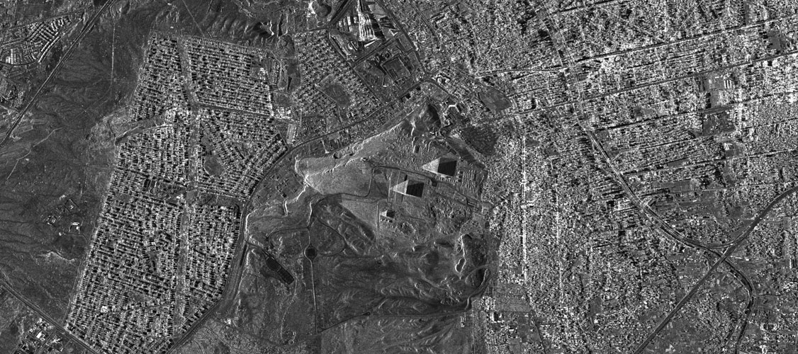
Great Pyramids of Giza, Egypt - This PAZ image was acquired in high resolution SpotLight image mode on 22 September 2019 and shows the Great Pyramids of Giza, in Egypt. The pyramids and the Giza Necropolis are clearly visible in the centre of the image, surrounded by the city of Giza itself. Copyright: PAZ satellite image © Hisdesat Servicios Estratégicos S.A. 2019
Great Pyramids of Giza, Egypt - This PAZ image was acquired in high resolution SpotLight image mode on 22 September 2019 and shows the Great Pyramids of Giza, in Egypt. The pyramids and the Giza Necropolis are clearly visible in the centre of the image, surrounded by the city of Giza itself. Copyright: PAZ satellite image © Hisdesat Servicios Estratégicos S.A. 2019
View full image
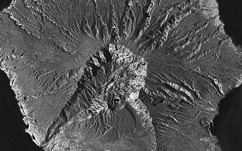
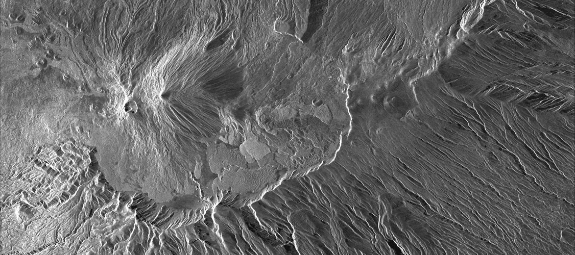
Mount Teide, Tenerife, Canary Islands - We return to the Canary Islands in this PAZ image, which was acquired in StripMap image mode on 23 April 2020. The image focuses on Mount Teide, the volcano that dominates the centre of Tenerife Island. In the full image we can see areas of habitation on the north and south ends of the island. Copyright: PAZ satellite image © Hisdesat Servicios Estratégicos S.A. 2020
Mount Teide, Tenerife, Canary Islands - We return to the Canary Islands in this PAZ image, which was acquired in StripMap image mode on 23 April 2020. The image focuses on Mount Teide, the volcano that dominates the centre of Tenerife Island. In the full image we can see areas of habitation on the north and south ends of the island. Copyright: PAZ satellite image © Hisdesat Servicios Estratégicos S.A. 2020
Slide 0 of 0