SIRAL Overview
Design
CryoSat's SAR Interferometric Radar Altimeter (SIRAL) works by sending a radar pulse towards the Earth's surface and studying the return echoes that reach the sensor. By knowing the position of the spacecraft, achieved using a Doppler Orbit and Radio Positioning Integration by Satellite (DORIS) receiver, and small laser retroreflector , the signal return time will reveal the surface altitude.
The SIRAL instrument combines a conventional pulse-limited radar altimeter, with synthetic aperture and interferometric signal processing. SIRAL is a single frequency Ku-band radar altimeter capable of operating in three modes: Low Resolution Mode (LRM), Synthetic Aperture Radar (SAR) and SAR Interferometric (SARIn or SIN) mode. Each mode is designed for optimal measurements over different surfaces.
Knowledge of the precise orientation of the baseline and the two receiving antennas is essential for the success of the mission. Correct baseline orientation is maintained using a trio of star trackers.
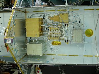
CryoSat carries two SIRAL instruments: one operational and one serving as a backup in case this fails.
SIRAL was designed and developed for ESA by Thales Alenia Space and is of Poseidon-2 heritage, an instrument carried on the Jason-1 mission.
Sensor Modes
SIRAL operates in three measurement modes:
Low Resolution Mode (LRM):
- Over the ice sheet interiors, oceans and land not covered by other modes, SIRAL operates in LRM
- This mode is similar to the operation of conventional pulse width-limited altimeters and uses a single receive channel. The Pulse Repetition Frequency (PRF) is low and the echoes are transmitted to the ground segment in the spectral domain after on board averaging. The data rate is therefore low.
Synthetic Aperture Radar (SAR) mode:
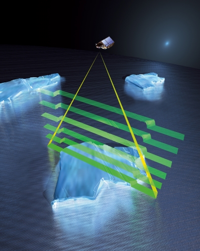
- Over sea ice areas coherently transmitted echoes are combined via SAR processing, to reduce the surface footprint and enable SIRAL to map smaller ice floes. This mode is used to obtain high-resolution measurements of floating sea ice, enabling the indirect measurement of sea ice thickness. SAR mode is also operated over some ocean basins and coastal zones.
- In SAR mode, which also uses a single receive channel, the along-track horizontal resolution of the altimeter is enhanced by exploiting the Doppler properties of the echoes as they cross the antenna beam width, by on-ground processing. The result is equivalent to decomposing the main antenna beam into a set of 64 narrower synthetic beams along track. Consequently, a larger number of independent measurements are available over a given area, which is used to enhance the accuracy of the measurements over sea ice. In order to ensure the coherence between echoes from successive pulses, the PRF is about 10 times higher than for LRM and the instrument operates in burst mode. The echoes are transmitted to the ground segment in the time domain, prior to any averaging, therefore the data rate is significantly higher than for LRM.
SAR Interferometric (SARIn) mode:
- SIRAL's most advanced mode, SARIn, is used over ice sheet margins, small ice caps and mountain glaciers. It is also operated over some geostrophic ocean currents and major hydrological basins.
- Here, the altimeter performs synthetic aperture processing and uses a second antenna as an interferometer to determine the across-track angle to the earliest radar returns. The combination of SAR and interferometry makes it possible to accurately determine the arrival direction of the echoes both along and across the satellite track, by comparing the phase of one receive channel with respect to the other. This information is required to derive the height of the surface from the range measurement of the radar.
- SARIn mode provides the exact surface location being measured when the surface is sloping and can be used to study steep and mountainous terrains
- In SARIn mode both receive channels are active and the corresponding echoes are transmitted to the ground in the time domain. The data rate is about twice as high as for SAR mode. In order to cope with abrupt height variations, the range-tracking concept for this mode has to be particularly robust. In SIRAL, this is ensured by using narrow-band tracking pulses, transmitted in-between successive wide-band measurement bursts.