 Krakatoa Volcano, Indonesia
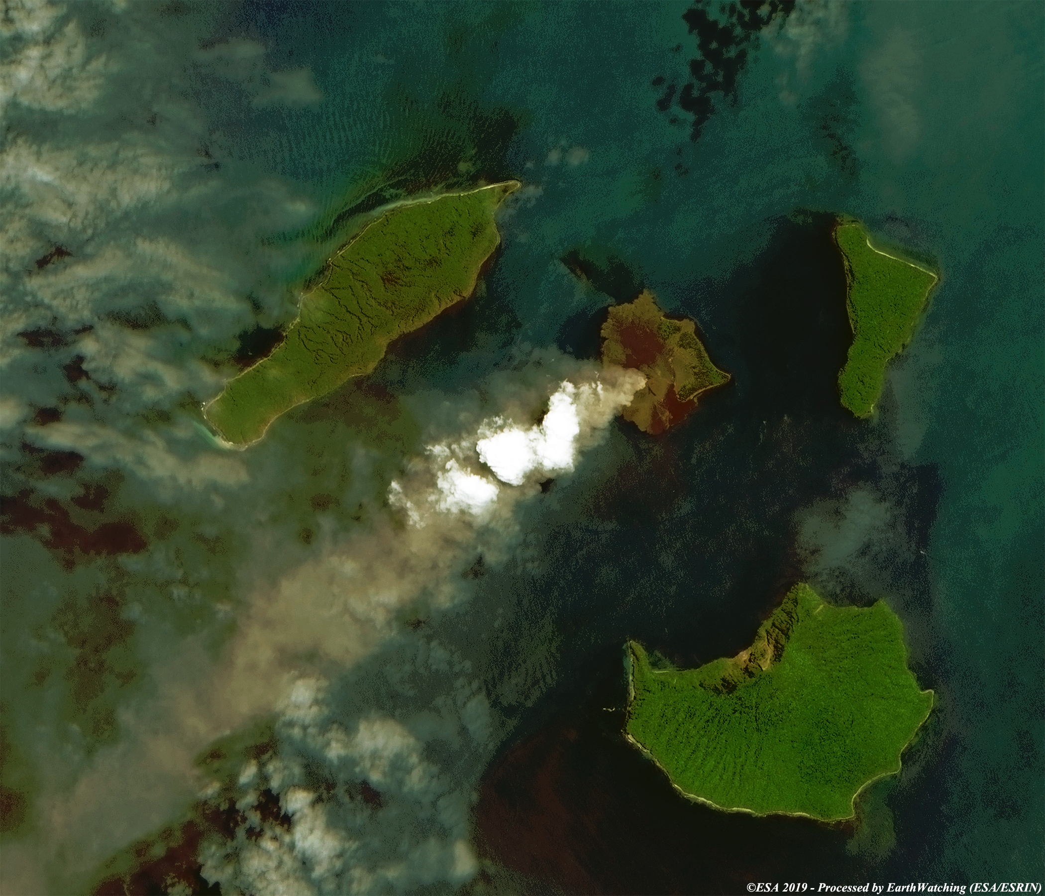
Krakatoa, or Krakatau, is a caldera situated in the Sunda Strait between the islands of Java and Sumatra in the Indonesian province of Lampung. The name is also used for the surrounding volcanic island group (Krakatoa Archipelago) comprising four islands: two of which, Lang and Verlaten, are remnants of previous volcanic edifices destroyed in eruptions long predating the famous 1883 eruption; another, Rakata, being the remnants of a much larger island destroyed in the aforementioned eruption. In 1927, a fourth island, Anak Krakatau, or "Child of Krakatoa", emerged from the caldera formed in 1883. It is the current location of eruptive activity.
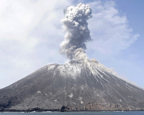
Jakarta (From AFP, December 23, 2018) - The volcano that triggered a deadly tsunami in Indonesia late Saturday emerged from the sea around the legendary Krakatoa 90 years ago and has been on a high-level eruption watchlist for the past decade. Anak Krakatoa (the "Child of Krakatoa") has been particularly active since June, occasionally sending massive plumes of ash high into the sky and in October a tour boat was nearly hit by lava bombs from the erupting volcano. Experts say Anak Krakatoa emerged around 1928 in the caldera of Krakatoa, a volcanic island that violently erupted in 1883. With subsequent lava flows it grew from a submarine setting to become a small volcanic island, with the cone now standing at an altitude of around 300 metres (1,000 feet) above sea level. Since its birth, Anak Krakatoa has been in a "state of semi-continuous eruptive activity", growing bigger as it experiences eruptions every two to three years, volcanology professor Ray Cas from Monash University in Australia told AFP. "Most of the eruptions are relatively small on the scale of explosive eruptions ... and there's also eruptions that produce lava flows," he added. Cas said the latest event appeared to be "a relatively small explosive eruption" but could then have triggered or coincided with a submarine event like a landslide or earthquake, causing the deadly tsunami. No one lives on the island, but the peak is popular with tourists and is a major study area for volcanologists. The island is part of the Ujung Kulon National Park, "demonstrating on-going evolution of geological processes", since the Krakatoa eruption, UNESCO says on its World Heritage site listing for the area. When Krakatoa erupted on August 27, 1883 it shot a column of ash more than 20 kilometres (12 miles) into the air in a series of powerful explosions that were heard in Australia and up to 4,500 kilometres away near Mauritius. The massive cloud of ash plunged the area into darkness for two days. The dust gave rise to spectacular sunsets and sunrises around the world the following year and disrupted weather patterns for years. The tsunami triggered by the eruption killed more than 36,000 people in one of the world's worst natural disasters. Indonesia's proximity to the junction of three continental plates, which jostle under immense pressure, makes it particularly vulnerable to earthquakes and eruptions. The archipelago nation has nearly 130 active volcanoes, forming part of the Pacific "Ring of Fire" -- an arc of intense seismic activity that stretches from quake-prone Japan through Southeast Asia and across the Pacific basin. Read more in Yahoo news.
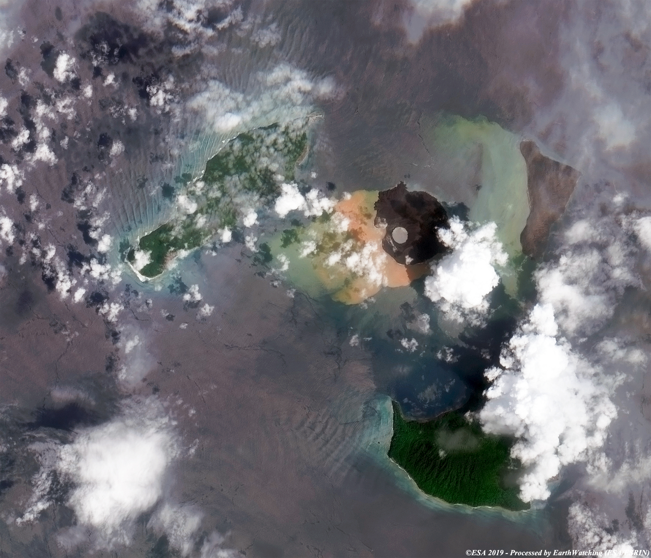
The images below, acquired from the Copernicus Sentinel-2 satellite, show the Krakatoa Volcano before and after its latest eruption in December 2018. 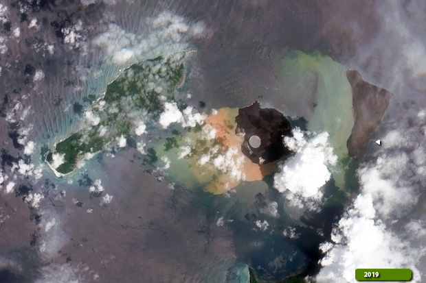 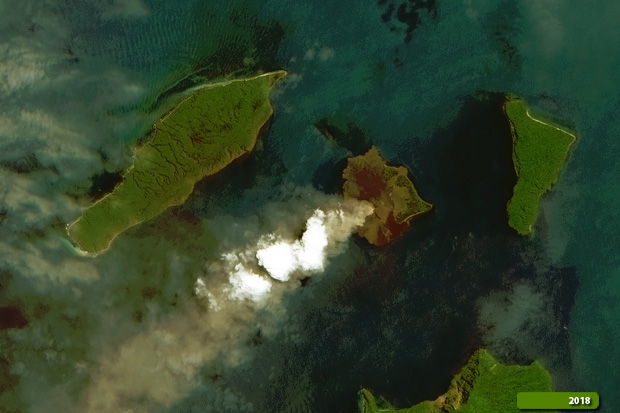 View large format slider in natural color bands View Sentinel-2 high resolution image (After) (JPG 2.7 MB) View Sentinel-2 high resolution image (before) (JPG 3.7 MB)
|
|||||||||||||||||||