 Browse SAR Events by Year
20 Years of SAR
Browse SAR Events by Year
20 Years of SAR
 View large format Jpeg (268 Kb)
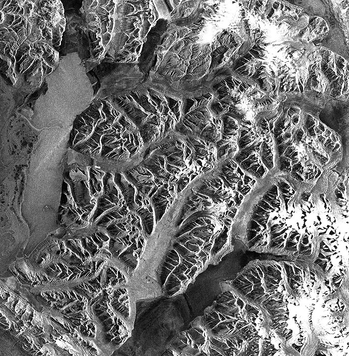
Svalbard, Norway Svalbard, stretching between 76 and 80 degrees north, means 'the land with the cold coasts'. The name was mentioned in the Icelandic sagas already in 1194. It was discovered in 1596 by the Dutch captain Willem Barents, trying to find a northern seaway to the Orient. He named the area Spitsbergen because he saw a lot of mountains with sharp peaks separated by glaciers. In the beginning of the seventeenth century the Englishman Henry Hudson discovered that the waters around Svalbard were very rich in whales. When his discovery became known in Europe a very active whaling period commenced along the west coast of Spitsbergen and lasted to the middle of the seventeenth century, at which time the whales were nearly extinct. During the beginning of the eighteenth century Svalbard was colonized by trappers and hunters of walruses, seals, reindeer, polar bears and foxes. To be a successful trapper they had to spend the winters on Svalbard and many perished due to a very harsh life or to scurvy. In fact the mean air temperature at sea level is minus 6.5 degrees centigrade. During the second half of the nineteenth century Svalbard became a very popular and important area for scientific research, especially geology and natural sciences. During this period Nordenskiõld and others started mining phosphates, gypsum and marble. None of these industrial attempts became commercially successful. But the American John M. Longyear was one of the first to open a profitable coal mine at Advent Bay (Advent City, today Longyearbyen), and others followed. The Dutch opened Barentsburg but sold the mine to the Russians in 1936. Today practically all of these mines are closed and human activities concentrate on scientific research of which Kings Bay A/S, at Ny-Ålesund is world famous among scientists. There is also a growing demand for tourism. Our image shows the central part of the Spitsbergen Island, with all the many fjords, steep flanks of mountains (very dark), some pointed but some forming high plains. Large parts of the country are glaciated and glacier tongues calve their ice into the sea. Due to the early period in the year of satellite data acquisition the fjords are covered with ice. But depending on the orientation of the fjord the wind-packed ice is of different type and origin, as revealed by the graytone in the image. The higher glacier surfaces appear bright due to the penetration of the radar microwave into the dry snow pack, strongly backscattering at large ice crystals. In the top left corner (enlargement) a succession of geological layers is visible. They were deposited during the Mesozoic area in a warm climate inhabited by dinosaurs. Footprints of Iguanodon have been found near Barentsburg (lower left enlargement). An other Mine is Sveagruva (central-right enlargement). Longyearbyen (enlargement left central part) is the only settlement well visible, nearby is also the airport that allows a daily connection with the motherland Norway. On the plateau just above the airport the Svalbard satellite station is located (brighter point). Due to its northern position, it is the only satellite station that can track all orbits of polar-orbiting satellites, such as ERS and ENVISAT. |
||