- All Categories (15257)
- Data (2)
- News (41)
- Missions (61)
- Events (10)
- Activities (6)
- Campaigns (2)
- Documents (15135)
MISSIONS
Explore the European Space Agency's Earth Observation satellite missions. Learn all about ESA's dedicated Earth Explorers or collaborations with other agencies through the Third Party Missions programme.
Mission - Earth Explorers

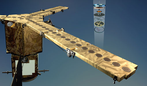
GOCE
Explorer (GOCE) mission mapped Earth's geoid very accurately, opening a window into Earth's interior structure as well as the currents
Mission - Earth Explorers

Swarm
its geological interpretation Determination of the 3D electrical conductivity of the mantle Investigatigation of electric currents
Mission - Third Party Missions

ICEYE
Currently, the satellites operate in five modes called 'Strip Mode', 'Spot Mode', 'Scan Mode', 'Spot Extended Area (SLEA)
Mission - Earth Explorers

FLEX
Currently it is not possible to measure photosynthetic activity from space, but FLEX's novel instrument will be capable of
Mission - Heritage Missions

Seasat
The instrument had the objectives of the determination of sea surface profiles, currents, wind speeds and wave heights.
Mission - Earth Explorers
SMOS product availability
+ NIR + Long LO + FTT LO + Electrical Stability LO + NIR + Long + FTT LO + Short LO + Long + Short Current
Mission - Earth Explorers
Swarm Data
FIND OUT MORE The Average Magnetic field and Polar current System model (AMPS) The Average Magnetic field and Polar current
Mission - Third Party Missions

SAR (JERS-1) Processor Releases
The current JERS-1 SAR Instrument Processing Facility (IPF) version is v2.05p3, which was released on the 21 September 2015
Mission - Earth Explorers
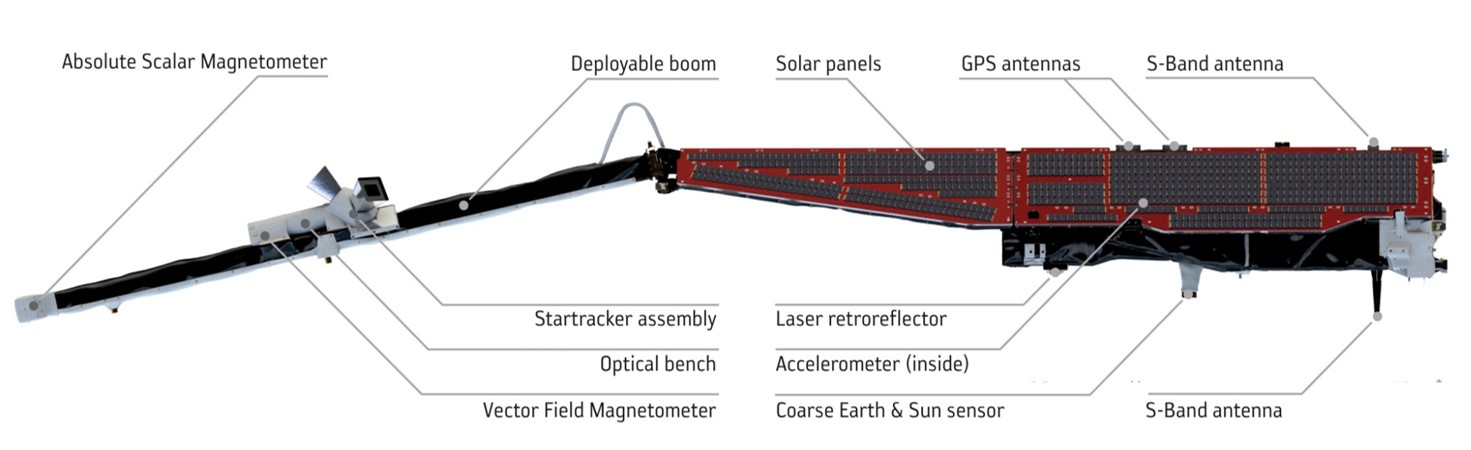
STR (Swarm)
identification of opportunities for auroral research utilising Swarm data. find out more The Average Magnetic field and Polar current
Mission - Earth Explorers
Geographical Mode Mask
The current operational Geographical Mode Mask v5.0 The current version of the geographical mode mask v5.0 has been in operation
Mission - Heritage Missions
SAR (ERS) Processor Releases
It should be noted that for SAR, each product ordered is processed directly from the raw data, using the current version
Mission - Earth Explorers
GOCE Objectives
Thanks to this current, the coastal waters of Europe are 4°C warmer than waters at equivalent latitudes in the north Pacific
Mission - Earth Explorers
Swarm Objectives
magnetisation and its geological interpretation determine the 3D electrical conductivity of the mantle investigate electric currents
Mission - Heritage Missions
Seasat Objectives
wealth of information on diverse ocean phenomena such as sea-surface winds and temperatures, surface and internal waves, currents
Mission - Heritage Missions

ASAR Processor Releases
August 2009 5.03L03 9 October 2009 5.04 17 September 2010 6.00 16 December 2011 6.02 30 April 2012 6.03 3 July 2015 (current
Mission - Earth Explorers

SMOS Objectives
SMOS Science The SMOS mission is a direct response to the current lack of global observations of soil moisture and ocean
Mission - Earth Explorers

Special Datasets Overview
CryoSat Antarctic Digital Elevation Model - Download the current CryoSat product Antarctic DEM.
Mission - Heritage Missions
SCIAMACHY Auxiliary Data
In these cases, default values for the calibration parameters (Leakage current, Pixel-to-Pixel Gain and Etalon, Spectral
Mission - Heritage Missions

Products Availability L0
The current list of gaps in the AATSR Level 0 dataset is available here.
Mission - Heritage Missions

RA (ERS)
the RA provided information on significant wave height; surface wind speed; sea surface elevation, which relates to ocean currents