- All Categories (4989)
- Data (3)
- News (18)
- Missions (20)
- Events (23)
- Tools (1)
- Activities (11)
- Documents (4913)
Document - Product Specifications

wind-scatterometer-processing-requirements-from-sigma-nought-triplets-to-dealiased-wind.pdf
This document defines the ground processing algorithms for the ERS-1 AMI wind mode (Scatterometer) from the sigma nought triplets to the wind speed and direction, including the wind retrieval and the ambiguity removal processing.
Mission - Heritage Missions

Wind Scatterometer (WS) Quality Control Reports
The data includes instrument working modes, temperatures, currents and voltages of the transmitter and calibration chain,
Mission - Heritage Missions
Wind Scatterometer (WS) Processor Releases
The current processor software version for the operational ground segment is ASPS v 10.04.
Mission - Heritage Missions
Wind Scatterometer (WS) Cal/Val
ERS-2 Scatterometer: Mission Performances and Current Reprocessing Achievements Calibration strategy for ERS scatterometer
Document - General Reference

WATS - Water Vapour and Temperature in the Troposphere and Stratosphere.pdf
This report describes the WATS mission, one of the candidate Earth Explorers in the second cycle in 2001.
Document - Technical Note

WALES - Water Vapour Lidar Experiment in Space
This report describes the WALES mission, one of the candidate Earth Explorers in the second cycle in 2001.
Event - Meeting

VH-RODA and CEOS SAR workshop
The workshop provided an open forum for the presentation and discussion of current status and future developments related
Mission - Earth Watch
Vegetation (VGT) Quality Control Reports
months and provide information about: Absolute and inter-band radiometric accuracy Multi-temporal radiometric accuracy Dark current
Mission - Earth Watch
Vegetation (VGT) Processor Releases
The current processor software version, used for a full reprocessing of the PROBA-V archive and also for the operational
Mission - Earth Watch
Vegetation (VGT) Cal/Val
Greenland (only during June/July): during one week daily acquisitions in uncompressed mode Weekly Calibration acquisition Dark current
Document - Technical Note
UWA Processing Algorithm Specification
This technical note specifies version 2 of the algorithm to derive SAR wave spectrum products from ERS AMI wave mode data.
Activity - Cal/Val activities

UV nadir viewing galleries
Download chart A new perspective on the current state of the ozone layer derived using the merged total ozone data record
Document - Publication - Paper

Uniqueness of the ERS Scatterometer for nowcasting and typhoon forecasting
Paper presented to IGARSS-2005: Uniqueness of the ERS Scatterometer for nowcasting and typhoon forecasting
Document - General Reference
Two Years of ERS-1 Data Exploitation
This bulletin reports on the first two years of the ERS-1 satellite.
News - Thematic area articles

Transforming space data into climate action
By combining high-quality data from both current and previous missions, scientists are improving their understanding of the
News - Success Stories
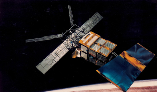
Trailblazing ERS-2 mission enables climate change applications
Varied elevations of Bachu in western China InSAR is currently one of the most accurate methods to generate digital elevation
Document - General Reference
Towards More Efficient Use of Radar-Altimeter Data
Twenty years ago, experimental altimeters on NASA's Skylab and Geos-3 were already demonstrating the potential of such instrumentation. This led in turn to the development and launch by NASA in July 1978 of the Seasat oceanographic satellite mission. Both Geos-3 and Seasat were very successful in their pioneering missions, but were limited somewhat by poor coverage in the case of Geos-3 and an abnormally short mission duration in Seasat's case.