- All Categories (13253)
- News (27)
- Missions (10)
- Events (2)
- Campaigns (2)
- Documents (13212)
Document - General Reference

WATS - Water Vapour and Temperature in the Troposphere and Stratosphere.pdf
This report describes the WATS mission, one of the candidate Earth Explorers in the second cycle in 2001.
Document - Technical Note

WALES - Water Vapour Lidar Experiment in Space
This report describes the WALES mission, one of the candidate Earth Explorers in the second cycle in 2001.
News - Thematic area articles

Transforming space data into climate action
By combining high-quality data from both current and previous missions, scientists are improving their understanding of the
News - Success Stories
Trailblazing ERS-2 mission enables climate change applications
Varied elevations of Bachu in western China InSAR is currently one of the most accurate methods to generate digital elevation
Document - General Reference
The-Changing-Earth-New-Scientific-Challenges-for-ESAs-Living-Planet-Programme.pdf
This article is extracted from ESA Bulletin Nr. 129.
News - Data Release news

Systematic swath elevation and monthly DEMs over the Greenland Ice Sheet margin from CryoSat
Land-ice monitoring via Earth Observation methods in general, and altimetry in particular, are essential for tracking the current
News - Data Release news

Systematic swath elevation and monthly DEMs over the Antarctica Ice Sheet margin from CryoSat 2
Land-ice monitoring via Earth Observation methods in general, and altimetry in particular, are essential for tracking the current
News - General News
Stunning new features for ESA and NASA altimetry portal cs2eo.org
Currently available polygons include a selection of glacier outlines from the Randolph Glacier Inventory (RGI) Version 6,
Mission - Earth Explorers

Special Datasets Overview
CryoSat Antarctic Digital Elevation Model - Download the current CryoSat product Antarctic DEM.
Event - Workshop

Space and the Arctic 2009 Workshop
possibilities for the future : Volker Liebig, Director of ESA EO Programme Observations of the Arctic - EUMETSAT's Contribution to Current
Mission - Earth Watch

SIRAL Overview
It is also operated over some geostrophic ocean currents and major hydrological basins.
Mission - Earth Explorers
SIRAL
Access is provided to all CryoSat systematic data acquired according to the current geographical mode mask.
News - Thematic area articles

Satellites reveal changes to Earth’s icy zones
By combining information collected by current and previous missions, researchers can estimate how the cryosphere is evolving
News - Success Stories

Retrieving Snow Depth Over Sea Ice Using Dual-Frequency Altimetric Measurements
the launch of SARAL in 2013, have been shown to provide a better climatological solution than the snow depth climatology currently
News - Success Stories

Publication of Coastal Current Intrusions from Satellite Altimetry
A new study entitled “Coastal current intrusions from satellite altimetry” has just been published in the journal Remote
Mission - Earth Explorers

Products Information
here, these are intended for the purpose of becoming familiar with the format of the CryoSat Science Products from the current
News - Success Stories
New one-stop-shop for ESA and NASA altimetry data
Currently, the available standard combined products are: SAR Sea Ice (IS2 ATL07 vs CS2 SAR mode L2) – available for Arctic
News - Data Release news
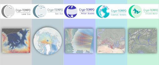
New CryoSat-2 Thematic Products Now Available
The current product release represents the culmination of Phase 1 of the Cryo-TEMPO activities, which began in October 2020
News - Data Release news

New CryoSat Ice Baseline-E 2016 and 2017 Reprocessed Data – Available now!
The Ice Baseline-E Reprocessing campaign is currently underway to reprocess all CryoSat ice products from July 2010 - August
News - Data Release news

New CryoSat Ice Baseline-E 2014 and 2015 reprocessed data – Available now!
The Ice Baseline-E Reprocessing campaign is currently underway to reprocess all CryoSat ice products from July 2010 - August