- All Categories (26)
- News (3)
- Missions (6)
- Events (6)
- Documents (11)
Mission - Earth Explorers

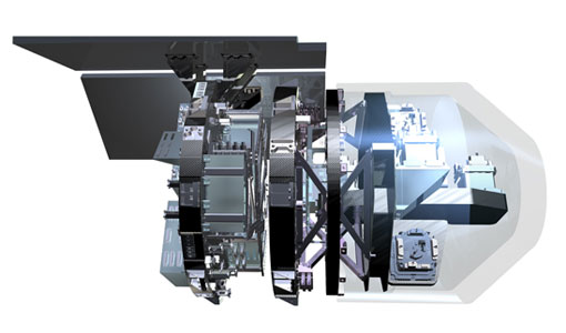
GOCE
Explorer (GOCE) mission mapped Earth's geoid very accurately, opening a window into Earth's interior structure as well as the currents
News - General News
Go-to guide to Third Party Mission data offering
Data Access Guide has been published, providing technical details and information on available data collections for all current
Event - Workshop

SEASAR 2012
Aouf 14:00 - 14:20 Towards consistent inversion of wind, waves and surface current from SAR Bertrand Chapron (IFREMER, France
Mission - Earth Explorers
GOCE Objectives
Thanks to this current, the coastal waters of Europe are 4°C warmer than waters at equivalent latitudes in the north Pacific
Event - Training

EO Summer School 3
In line with observations it shows anti-cyclonically rotating surface currents and cyclonically rotating bottom currents.
News - Thematic area articles

Satellite data central to ocean monitoring
microwave monitoring instruments, optical imagers, and infrared radiometers, which can map ocean variables related to ocean currents
Mission - Earth Explorers
EGG
This opened a window into Earth's interior structure, as well as the currents circulating within the depths of its oceans
Event - Workshop

Fringe 2011 Workshop
The Fringe series of workshops started in 1992 and they are currently organised by ESA every two years.
Mission - Earth Explorers
SSTI ANTEX Data
data were generated from 154 days in 2009 GOCE SSTI-B PCVs data were generated from the available data in 2010-2012 The current
Document - General Reference

The Nine Candidate Earth Explorer Missions - Topography Mission
This report for assessment addresses the Topography mission when it was selected with other nine Earth Explorer missions as a potential candidate for Phase A study.
Document - Proceedings

EO-Summer-School-6-ESA-explorer-mission-GOCE-earth-gravity-from-space.pdf
This presentation from ESA's EO Summer School 6 presents the ESA explorer mission GOCE earth gravity from space
Mission - Heritage Missions
GOCE re-entry dataset
with further dynamical and environmental information such as on-board magnetometer measurements of Earth's magnetic field, currents
Mission - Earth Explorers
GOCE Overview
height mapped by altimeters and the knowledge of the precise ocean geoid that has improved our understanding of surface currents
Event - Training
Advanced Training Course in Ocean Remote Sensing 2011
Background and access to current and future Chinese, ESA and TPM satellite missions in ocean remote sensing were presented
Document - General Reference
CoReH2O-Report-for-Mission-Selection-An-Earth-Explorer-to-observe-snow-and-ice.pdf
This report describes the CoReH2O (Cold Regions Hydrology high-resolution Observatory) mission, which was selected for feasibility study in the third cycle of Earth Explorers.
Document - Proceedings
Fringe-2011-workshop-session-summaries.pdf
This document contains the session summaries from the session summaries of the Fringe 2011 workshop.
Document - Proceedings
Fringe-2011-workshop-recommendations.pdf
This document contains the recommendations from the session summaries of the Fringe 2011 Workshop.
Document - General Reference
The-Changing-Earth-New-Scientific-Challenges-for-ESAs-Living-Planet-Programme.pdf
This article is extracted from ESA Bulletin Nr. 129.
Event - Training
EO Summer School 6
Keynote lectures on global change issues are also given to discuss the current state of the science of global change and
News - Thematic area articles

Satellites reveal changes to Earth’s icy zones
By combining information collected by current and previous missions, researchers can estimate how the cryosphere is evolving