- All Categories (23699)
- Data (27)
- News (24)
- Missions (1)
- Events (16)
- Tools (15)
- Activities (4)
- Campaigns (24)
- Documents (23488)
Success Stories
Read articles about the successes of ESA's mission programmes and applications of the data obtained by the satellites.
News - Success Stories
7 Feb 2024Trailblazing ERS-2 mission enables climate change applications
As ESA’s ERS-2 satellite approaches Earth’s atmosphere for reentry, it’s time to reflect on the mission’s great achievements in powering climate-related applications.
News - Success Stories
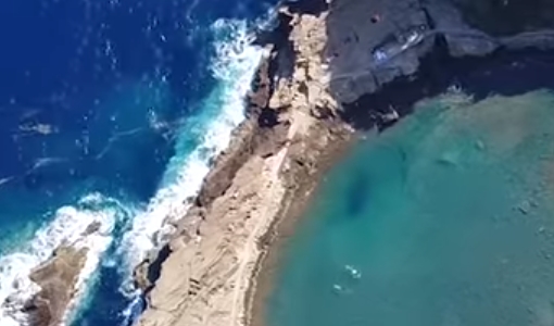
5 Dec 2023CryoSat land ice data track destabilisation of Antarctic glacier
Even apparently stable glaciers in Antarctica are at risk of losing large quantities of ice due to warming seas. The warning comes after satellite data showed the Cadman glacier – previously stable for 50 years - retreated by 8 km between November 2018 and May 2021.
News - Success Stories
24 Nov 2023CryoSat safe and sound
A fuel leak aboard the CryoSat satellite threatened to bring the mission to an end in 2025 however operators at ESOC initiated a swap to a back-up system thus saving the satellite for years to come.
News - Success Stories
31 Aug 2023New CryoSat data to boost understanding of the oceans
A new CryoSat sea level anomaly product designed to enable ocean science and the development of operational marine applications has been released.
News - Success Stories
29 June 2023ESA missions help to reveal worldwide lake water loss trend
Climate change, human consumption and sedimentation are depleting more than half of the world’s biggest lakes of water, according to a ground-breaking analysis that drew on three decades of satellite data.
News - Success Stories
28 Apr 2023ESA missions deliver new long-term perspective on sea ice decline
A 29-year timeseries of polar sea ice thickness and volume that draws on altimetry data from a succession of ESA missions has been presented at the European Geoscience Union general assembly.
News - Success Stories
 22 Nov 2022
Robust airborne radar instrument aids CryoSat ice data
During the 12 years that ESA’s ice mission – CryoSat – has been monitoring Earth’s ice masses from space, simultaneous airborne measurements were made by ASIRAS.
News - Success Stories
 6 Oct 2022
Decades of satellite data reveal the risks of climate tipping points
Decades-long time series that draw on ESA’s Earth observation archives are enabling scientists to uncover the threat of sudden and potentially irreversible changes to the icy parts of the planet.
News - Success Stories
 12 July 2022
CRYO2ICE over Antarctica: revealing further insight on changing ice
The CryoSat-2 satellite is currently being aligned with ICESat-2 over Antarctica, unlocking fresh possibilities in the wealth of new information being delivered by the near-synchronous orbit of the two satellites.
News - Success Stories
 19 May 2022
New one-stop-shop for ESA and NASA altimetry data
cs2eo.org is a free, easy-to-use portal to explore, combine and download airborne and spaceborne altimetry data from CryoSat-2, ICESat-2, CryoVEx, IceBridge and CryoTEMPO-EOLIS.
News - Success Stories
 21 Dec 2021
Retrieving Snow Depth Over Sea Ice Using Dual-Frequency Altimetric Measurements
A new study from the sea ice team of the Laboratory of Space Geophysical and Oceanographic Studies (LEGOS) in Toulouse has shown that dual-frequency SARAL and CryoSat-2 altimetric measurements can be used to retrieve consistent snow depth data over sea ice in both hemispheres.
News - Success Stories
 25 Nov 2021
COP26 fuels interest in satellite data
As COP26 stimulates action to reduce global warming, the essential role of satellite data in understanding and monitoring climate change is apparent.
News - Success Stories
 24 Nov 2021
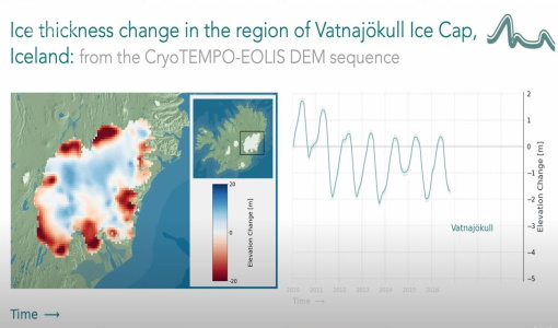
CryoTEMPO-EOLIS Products Now Available for Iceland, Svalbard, and the Canadian Arctic
Land-ice is declining globally, raising sea levels worldwide and impacting glacial risks and access to fresh-water in high-mountain glaciers regions. Land-ice monitoring via Earth Observation methods in general, and altimetry in particular, are essential for tracking the current status of ice volume change and its evolution as climate continues to evolve and mitigating actions are being pursued.
News - Success Stories
 15 Oct 2021
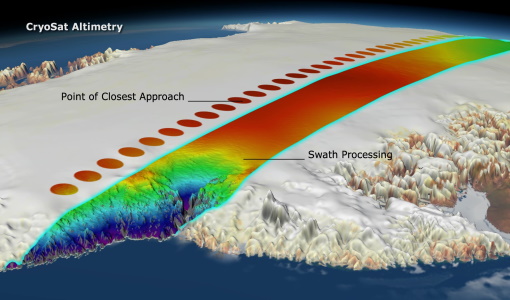
CryoSat's Swath Processing Technique
For more than 30 years, satellite radar altimetry has been used to continuously monitor the state of the cryosphere and to investigate the impact of global warming on sea level rise. Owing to this, maps of ice sheet elevation and elevation change were derived.
News - Success Stories
 22 Dec 2020
Using Satellite Data to Predict Floods and Droughts
Scientists are turning to remote sensing to fill the in-situ data gap in hydrological data models in some parts of the world.
News - Success Stories
 10 Nov 2020
Publication of Coastal Current Intrusions from Satellite Altimetry
A new study entitled “Coastal current intrusions from satellite altimetry” has just been published in the journal Remote Sensing. This study comes from an international collaboration between the European Space Agency (ESA), MIO (Fr), CNR (It) and Serco (It) with the goal of monitoring coastal intrusions into the Gulf of Lion by analyzing multi-mission Satellite Altimetry data with Machine Learning methods
News - Success Stories
 30 Oct 2020
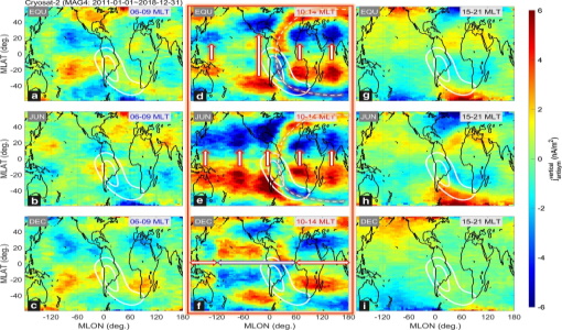
CryoSat-2 Data Used to Measure Ionospheric Currents
A new study has shown that navigation magnetometer data from the CryoSat-2 and Gravity Recovery and Climate Experiment Follow-On (GRACE-FO) satellites can be used to diagnose weak low-/mid-latitude ionospheric currents.
News - Success Stories
 30 Apr 2020
Mission continuity
Long-term availability of Earth observation data from a given instrument is crucial to many data users and their research—but just how does it work?
News - Success Stories
 22 Apr 2020
Earth Day: taking the pulse of our planet
While news of COVID-19 dominates headlines and many of us practice social distancing, there still remains the need for action on climate change - and satellites are vital in providing the key facts on this global issue.
News - Success Stories
 8 Apr 2020
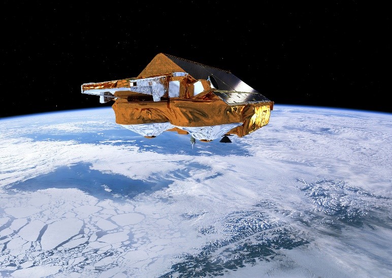
CryoSat still cool at 10
Today marks 10 years since a Dnepr rocket blasted off from an underground silo in the remote desert steppe of Kazakhstan