- All Categories (59)
- Data (1)
- News (26)
- Missions (2)
- Events (18)
- Tools (1)
- Activities (2)
- Documents (9)
NEWS
Discover the latest news on the European Space Agency's Earth Observation activities. Learn all about new data availability and how ESA's missions are performing.
News - Data Release news
8 Mar 2024FDR4ALT - ESA unveils new cutting-edge ERS/Envisat Altimeter and Microwave Radiometer Datasets
The European Space Agency (ESA) has developed a comprehensive suite of innovative Earth system data records as part of the Fundamental Data Records for Altimetry project - FDR4ALT.
News - Operational News
 12 Feb 2024
Temporary interruption to Envisat AATSR dissemination service
A planned downtime will affect the access to the ftp dissemination server for the Envisat AATSR data during the period 13-15 February 2024.
News - Thematic area articles
7 Dec 2023How to use space data to probe humankind’s ancient past
Data disseminated by ESA’s Third Party Missions (TPM) programme are enabling archaeological investigations that could help to unravel the mysteries of past societies and cultures.
News - Infographics
5 July 2023Focusing on Envisat MERIS Full Resolution Level-2 data
ESA's Envisat mission continued and expanded upon the legacy of its predecessors, the ERS (European Remote Sensing) satellites. Operating between 2002 and 2012, the satellite's 10 instruments acquired a decade of data for many applications.
News - Infographics
8 June 2023Overview of the Aeolus Level-1B wind product
Learn about the Aeolus Level-1B wind product, which supports applications for the weather, atmospheric processes and climate research, in our latest infographic.
News - Thematic area articles
25 May 2023How satellite data empower sustainable urban growth
Earth observation is a vital tool for facilitating the sustainable development of the world's cities, helping to ensure that urban centres keep spurring collaboration, innovation and opportunity as they continue to expand.
News - Success Stories
23 May 2023Aeolus enhances volcanic ash forecasts for aviation safety
A new study, using wind data from ESA’s Aeolus mission, highlights the importance of using satellite missions like Aeolus to improve volcanic ash forecasting and ensure aviation safety in the future.
News - Success Stories
4 Apr 2023Envisat data show how volcanoes communicate with each other
Using radar data from ESA’s Envisat mission, scientists have recently proven the elastic interaction between two Hawaiian volcanoes.
News - Announcement of Opportunity updates
 14 Mar 2023
Researchers called to explore new applications of SAOCOM data
ESA has invited Earth observation experts to devise and propose innovative applications for data delivered by Argentinian remote sensing constellation SAOCOM.
News - Success Stories
7 Feb 2023ESA’s wind mission helps investigate the nature of volcanic plumes
An analysis that drew on wind profiles from ESA’s Aeolus mission has resulted in an unexpected discovery concerning the structure and behaviour of plumes emanating from the eruption of the Raikoke volcano in 2019.
News - Success Stories
 17 Nov 2022
New worldwide dataset captures the planet in fine detail
Scientists have developed an open source planetwide dataset of high-resolution Earth observation imagery, thanks to commercial data delivered by ESA’s Third Party Missions (TPM) programme.
News - Thematic area articles
 29 Sept 2022
How satellite data help to shape society
Data from ESA’s Earth observation archives are improving understanding of the interactions between human activities and the environment, helping to power green economic development and boosting prosperity in Europe and beyond.
News - Spotlight on EO community
 22 Sept 2022
Meet a young researcher who studies the behaviour of volcanoes worldwide
Researcher Camila Novoa Lizama, of the University of Leeds, recently analysed how the use of Synthetic Aperture Radar (SAR) imagery over the Puyehue Cordón-Caulle Volcanic Complex, in Chile, acquired by ALOS-1, Envisat and the Copernicus Sentinel-1 satellites, helped her team to better comprehend the temporal and spatial behaviour of ground displacements before, during and after the volcano’s last eruption.
News - Infographics
 31 Aug 2022
An overview of the very high-resolution WorldView constellation
Learn about the WorldView constellation, part of ESA’s Third Party Missions programme, in this infographic.
News - Data Release news
 28 July 2022
Spot Extended Area mode added to ICEYE on-demand portfolio
As an evolution of Spot mode, Spot Extended Area products are now available with the same resolution of Spot data (ground resolution of 1 m) but enabling to cover the area of 225 km2 (15 x 15 km) in a single SAR image.
News - Infographics
 13 July 2022
The International Charter - Providing satellite data to support disaster response worldwide
Learn about the International Charter Space and Major Disasters in this new infographic.
News - Infographics
 14 June 2022
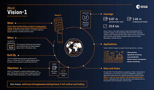
An overview of the very high-resolution Vision-1 satellite
Learn about Vision-1, which joined ESA's Third Party Missions programme in May, in our new infographic.
News - Events and Proceedings
 26 May 2022
Data preservation takes centre stage at Living Planet Symposium
Against the backdrop of the famed Rhine River, world-class scientists and Earth observation data-users are gathered this week in the historical city of Bonn, at the Living Planet Symposium (LPS).
News - Infographics
 20 Apr 2022
PlanetScope and SkySat - The high-resolution nanosatellite constellation
Find out more about the PlanetScope and SkySat missions in our new infographic.
News - Success Stories
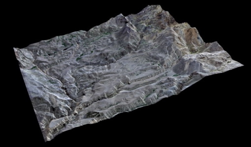 29 Mar 2022
High-resolution optical images improve geological mapping in remote geothermal areas
A group of researchers carried out a study on integrating remote sensing analysis with geological and geophysical fieldwork, over the Cerro Domuyo mountain in Patagonia-this led to the use of GeoEye-1 data, which proved to be invaluable, highly improving their understanding of the magmatic and tectonic evolution of this geothermal volcanic area.