- All Categories (111)
- Data (7)
- News (36)
- Missions (3)
- Events (17)
- Tools (6)
- Activities (1)
- Campaigns (1)
- Documents (40)
NEWS
Discover the latest news on the European Space Agency's Earth Observation activities. Learn all about new data availability and how ESA's missions are performing.
News - Events and Proceedings
 25 Oct 2021
Φ-Week Triumphs
In its fourth edition, Φ-Week presented the scientific community with amazing opportunities and projects—thus running alongside innovation at 360 degrees.
News - Success Stories
 23 June 2021
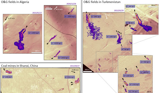
WorldView-3 satellite maps methane plumes at very high spatial resolution
Substantial advances have been made in the last years towards the detection and quantification of methane emissions from space- very high spatial resolution data from the WorldView-3 satellite can fill an important observational gap in the remote sensing of methane point emissions.
News - Success Stories
 6 July 2022
WorldView-3 helps to track offshore methane plumes from oil and gas
Scientists have used Earth observation data to reveal enormous methane plumes spilling out from an offshore oil and gas production rig in the Gulf of Mexico. This represents a significant breakthrough in the monitoring of industrial methane emissions from space.
News - Infographics
22 Feb 2023Twin satellites - TerraSAR-X and TanDEM-X
DLR's TerraSAR-X and TanDEM-X are twin satellites flying in close formation to acquire SAR data of unique geometric accuracy. Operating together, the missions deliver data that are used to generate Digital Elevation Models of Earth.
News - Data Release news
 7 Dec 2021
TerraSAR-X/TanDEM-X WorldDEM data now available to users
WorldDEM products have been added to the TerraSAR-X/TanDEM-X offering and are now available to users for research and application development following submission of a project proposal subject to evaluation and acceptance by ESA and the data owner.
News - Data Release news
 6 June 2019
TerraSAR-X ESA archive dataset now available
TerraSAR-X and TanDEM-X products are available to the scientific community.
News - Spotlight on EO community
7 May 2024Spotlight on Third Party Mission provider: EUSI
European Space Imaging (EUSI) is one of ESA’s suppliers of commercial Very High Resolution (VHR) satellite imagery for scientific research in Earth Observation (EO).
News - Thematic area articles
30 Jan 2024Space data support Earth’s ecosystems
ESA’s Earth observation (EO) missions are making a critical contribution to monitoring transformations in our planet’s ecosystems, helping track changes in the vegetation, soil, and ocean that affect these systems.
News - Success Stories
30 Jan 2023Showcasing success stories from ESA's Third Party Missions
ESA’s Third Party Missions programme consists of more than 50 missions from around the world.
News - Thematic area articles
 16 Aug 2022
Satellites reveal changes to Earth’s icy zones
ESA’s Earth observation activities are helping scientists investigate the influence of climate change on widespread ice-losses across the planet.
News - Thematic area articles
 2 Feb 2022
Satellite data boost global understanding of land surface
Understanding our changing land surface is essential in the study of climate change. Satellites are used to monitor changes to the material that covers Earth’s surface, so-called land cover, such as vegetation and water.
News - Data Release news
13 Feb 2024Sample data products from ESA’s Third Party Missions
Samples of data products from a range of Third Party Missions are now available to download, offering a preview of what these missions provide.
News - Success Stories
 4 Oct 2022
Remote sensing scientists raise alarm for African savannah
Researchers have used high resolution WorldView-3 imagery to map vegetation cover in the Greater Maasai Mara savannah, a global hotspot for biodiversity in Kenya.
News - General News
 13 June 2019
PolSARpro v6.0 (Biomass Edition) software new release
Download the latest version of ESA's Polarimetric SAR data Processing and Educational Toolbox (PolSARpro).
News - Success Stories
 17 Mar 2022
New open-source Python library improves rapid mapping services
In emergency services, rapid response is paramount. ICube-SERTIT’s Rapid Mapping Service provides near real-time delivery of geo-information to help emergency services respond quickly to disasters such as flooding, fires and landslides. A new Python open-source library, called EOReader, speeds up this mapping response by enabling the easy opening of imagery from multiple satellite sensors, both optical and synthetic aperture radar (SAR).
News - Events and Proceedings
 25 May 2022
National missions in the spotlight at the Living Planet Symposium
In the framework of ESA’s Third Party Missions (TPM) programme, the agency offers access to the full data archives of almost 50 satellite missions, which are owned by organisations around the world.
News - Spotlight on EO community
 18 Nov 2021
Meet a young researcher who combines remote sensing with deep learning techniques
Researcher MSc. Anupama Rajkumar recently investigated whether VHR satellite imagery could be combined with advanced deep learning techniques to automate the detection of waste landfills.
News - Success Stories
 10 Nov 2022
Long-term satellite data show wind farms can affect local air currents
Decades of satellite data have allowed for the first long-term study of the impact of offshore wind farms on downstream wind flow in coastal areas.
News - General News
16 Feb 2023International collaboration: Summarising ESA’s Third Party Missions
ESA’s Third Party Missions programme consists of more than 50 missions from around the world. Learn more about the Third Party Missions in this video.
News - Thematic area articles
7 Dec 2023How to use space data to probe humankind’s ancient past
Data disseminated by ESA’s Third Party Missions (TPM) programme are enabling archaeological investigations that could help to unravel the mysteries of past societies and cultures.