- All Categories (44)
- Data (3)
- News (6)
- Missions (2)
- Events (2)
- Tools (4)
- Documents (27)
Document - Proceedings
3rd-CHRIS-Proba-Workshop.pdf
Proceedings of the 3rd CHRIS/Proba Workshop, held from 21-23 March 2005 at ESA-ESRIN in Frascati, Italy.
News - Infographics
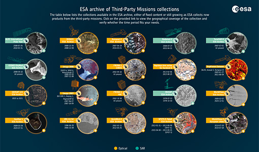
A summary of ESA Third Party Mission collections
A new summary is available, showcasing the ESA archives for Third Party Mission collections.
Document - Proceedings
Advances-in-Atmospheric-Science-and-Applications.pdf
Proceedings in Advances in Atmospheric Science and Applications held in 18-22 June 2012 in Bruges, Belgium.
Event - Conference
Atmospheric Science Conference 2006
The 2006 conference was dedicated the theme atmosphere to provide scientists and data users with the opportunity to present first-hand and up-to-date results from their ongoing research activities ESA Mission instruments.
Tools - Processing
Atmospheric Toolbox
The Atmospheric Toolbox (previously known as BEAT) is a collection of executable tools and API, developed to facilitate the utilisation, viewing and processing of e.g. GOMOS, MIPAS, SCIAMACHY and GOME data.
Mission - Third Party Missions
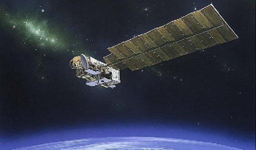
Aura
NASA's Aura mission studies the chemistry and dynamics of Earth's atmosphere from the ground through the mesosphere.
Data - External Data (Restrained)
Aura OMI complete NASA dataset
The OMI observations provide the following capabilities and features: A mapping of ozone columns at 13 km x 24 km and profiles at 13 km x 48 km A measurement of key air quality components: NO2, SO2, BrO, HCHO, and aerosol The ability to distinguish between aerosol types, such as smoke, dust and sulfates The ability to measure aerosol absorption capacity in terms of aerosol absorption optical depth or single scattering albedo A measurement of cloud pressure and coverage A mapping of the global distribution and trends in UV-B radiation. The OMI data are available in the following four levels: Level 0, Level 1B, Level 2, and Level 3. Level 0 products are raw sensor counts. Level 0 data are packaged into two-hour "chunks" of observations in the life of the spacecraft (and the OMI aboard it) irrespective of orbital boundaries. They contain orbital swath data. Level 1B processing takes Level 0 data and calibrates, geo-locates and packages the data into orbits. They contain orbital swath data. Level 2 products contain orbital swath data. Level 3 products contain global data that are composited over time (daily or monthly) or over space for small equal angle (latitude longitude) grids covering the whole globe.
Document - General Reference
Autonomy-in-action-Ten-years-of-Proba-1.pdf
This is an article extracted from the ESA Bulletin Nr.148.
Document - General Reference
Big-year-for-small-satellite-ESAs-second-in-orbit-technology-demonstration-mission-Proba-2.pdf
This is an article extracted from the ESA Bulletin Nr.144.
Document - General Reference
BIOMASS-Report-for-Mission-Selection-An-Earth-Explorer-to-observe-forest-biomass.pdf
The objective of the BIOMASS Mission is to determine the global distribution of forest biomass by reducing the uncertainty in the calculation of carbon stock and fluxes associated with the terrestrial biosphere.
Data - Announcement of Opportunity (Restrained)
Closed ESA announcement of opportunities
Find out about closed ESA announcement of opportunities and what these opportunities involved, for historical reference.
Document - Publication - Paper
Comparing Three Canopy Reflectance Models with Hyperspectral Multi-Angular Satellite Data
Studies that compare modelled reflectances with satellite-measured reflectances for different wavelengths and view angles are still rare. We compared model outputs from three different canopy reflectance models (SLC, FRT and INFORM) with satellite measured reflectances (Chris/PROBA).
Event - Workshop
Copernicus Sentinel-5 Precursor Validation Team Workshop
The purpose of the workshop was to gather feedback from the Sentinel-5P Validation Team (S5PVT) about the uncertainty characterisation of all Copernicus Sentinel-5P products.
Document - General Reference
CoReH2O-Report-for-Mission-Selection-An-Earth-Explorer-to-observe-snow-and-ice.pdf
This report describes the CoReH2O (Cold Regions Hydrology high-resolution Observatory) mission, which was selected for feasibility study in the third cycle of Earth Explorers.
Document - General Reference
Correction-of-systematic-spatial-noise-in-push-broom-hyperspectral-sensors.pdf
We present a new technique that faces the problem of removing the spatiallycoherent noise known as vertical striping, usually found in images acquired by push-broom sensors.
Document - General Reference
Earth-from-Space-Africa.pdf
This brochure is a collection of Envisat MERIS, Envisat ASAR and Proba HRC mosaics of Africa.
Document - General Reference
Earth-from-Space-China.pdf
This brochure is a collection of Envisat MERIS, Envisat ASAR and PROBA mosaics of China. The attached CD-rom contains the same images in electronic version.
Document - General Reference
Earth-from-Space-Deltas-and-Lakes.pdf
This brochure is a collection of Envisat MERIS, Envisat ASAR, ERS, Proba and Landsat mosaics.
Document - General Reference
Earth-from-Space-Deserts.pdf
This brochure is a collection of Envisat MERIS, Envisat ASAR, Proba and Landsat mosaics of desert areas on our planet.


