- All Categories (708)
- Data (18)
- News (54)
- Missions (3)
- Events (9)
- Tools (6)
- Activities (6)
- Campaigns (10)
- Documents (602)
Event - Meeting

20th GHRSST Science Team Meeting
The 20th GHRSST International Science Team meeting in 2019 brought together sea surface temperature experts to look at future innovations.
Event - Training

3rd Advanced Training Course on Land Remote Sensing 2011
This 2011 advanced ESA training course focused on land remote sensing theory and applications.
Document - Conference Presentation - Poster

8-Use_SAR_observing_Polar_lows.pdf
Use of SAR in observing Polar lows Birgitte Furevik (Norwegian Meteorological Inst., Norway)
News - Operational News
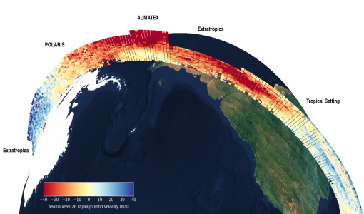
A Guide to Aeolus Range Bin Settings
After almost two years in space, Aeolus' near-real time observations have been assimilated into the Numerical Weather Prediction models of several European meteorological services, and have proven crucial during the COVID-19 pandemic, which led to a sharp decrease in meteorological observations.
Data - External Data (Restrained)

ADAM Surface Reflectance Database v4.0
ADAM enables generating typical monthly variations of the global Earth surface reflectance at 0.1° spatial resolution (Plate Carree projection) and over the spectral range 240-4000 nm. The ADAM product is made of gridded monthly mean climatologies over land and ocean surfaces, and of a companion API toolkit that enables the calculation of hyperspectral (at 1 nm resolution over the whole 240-4000 nm spectral range) and multidirectional reflectances (i.e. in any illumination/viewing geometry) depending on user choices. The ADAM climatologies that feed the ADAM calculation tools are: For ocean: Monthly chlorophyll concentration derived from SeaWiFS-OrbView-2 (1999-2009); it is used to compute the water column reflectance (which shows large spectral variations in the visible, but is insignificant in the near and mid infrared). Monthly wind speed derived from SeaWinds-QuikSCAT-(1999-2009); it is used to calculate the ocean glint reflectance. For land: Monthly normalized surface reflectances in the 7 MODIS narrow spectral bands derived from FondsdeSol processing chain of MOD09A1 products (derived from Aqua and Terra observations), on which relies the modelling of the hyperspectral/multidirectional surface (soil/vegetation/snow) reflectance. Uncertainty variance-covariance matrix for the 7 spectral bands associated to the normalized surface reflectance. For sea-ice: Sea ice pixels (masked in the original MOD09A1 products) have been accounted for by a gap-filling approach relying on the spatial-temporal distribution of sea ice coverage provided by the CryoClim climatology for year 2005.
Document - Publication - Paper

Advanced Scatterometer Processing System for ERS data
ASPS System and Product description presented at the ERS-ENVISAT Symposium Salzburg 2004: The Advanced Scatterometer Processing System for ERS Data: Design, Products, and Performances
Event - Training
Advanced Training Course in Land Remote Sensing 2012
The 2012 advanced training course focused on land remote sensing theory and applications.
Event - Training
Advanced Training Course in Ocean Remote Sensing 2011
Within the framework of the Dragon Programme, a joint collaboration between the European Space Agency (ESA) and the Chinese Ministry of Science and Technology (MOST), ESA and NRSCC are providing a series of advanced thematic training courses on remote sensing applications hosted by university and research institutions in P.R. China.
Mission - Earth Explorers

Aeolus
The Aeolus mission which was launched into space on 22 August 2018 and was retired on 30 April 2023, provided global observations of wind profiles from space to improve the quality of weather forecasts, and to advance our understanding of atmospheric dynamics and climate processes.
News - Infographics
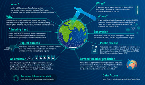
Aeolus - ESA's mission dedicated to winds, aerosols and clouds
Learn more about ESA's youngest Earth Explorer - the Aeolus mission - in our latest infographic
News - Operational News
Aeolus activates new range bin setting
On 17 June 2020, Aeolus will activate a new range bin setting, QBO2020 that will support the investigation of the Quasi-Biennial Oscillation (QBO) over the Tropical belt.
News - Operational News

Aeolus ALADIN energy increase from 29 August to 4 September
Between 29 August and 4 September the output energy of ALADIN will be increased in support of the upcoming JATAC campaign in September.
Document - Quality Report

Aeolus ALADIN Monthly L2B Report 01 Apr 2022
Aeolus ALADIN Monthly L2B Report
Document - Quality Report
Aeolus ALADIN Monthly L2B Report 01 Apr 2023
Aeolus ALADIN Monthly L2B Report
Document - Quality Report
Aeolus ALADIN Monthly L2B Report 01 Aug 2020
Aeolus ALADIN Monthly L2B Report
Document - Quality Report
Aeolus ALADIN Monthly L2B Report 01 Aug 2021
Aeolus ALADIN Monthly L2B Report
Document - Quality Report
Aeolus ALADIN Monthly L2B Report 01 Aug 2022
Aeolus ALADIN Monthly L2B Report
Document - Quality Report
Aeolus ALADIN Monthly L2B Report 01 Dec 2020
Aeolus ALADIN Monthly L2B Report
Document - Quality Report
Aeolus ALADIN Monthly L2B Report 01 Dec 2021
Aeolus ALADIN Monthly L2B Report
Document - Quality Report
Aeolus ALADIN Monthly L2B Report 01 Dec 2022
Aeolus ALADIN Monthly L2B Report