- All Categories (33)
- Data (11)
- News (10)
- Missions (4)
- Events (3)
- Tools (1)
- Campaigns (4)
News - Success Stories

How scientists are unlocking the potential of SAOCOM
A team of scientists has drawn on SAOCOM data to measure the heights of forests in Argentina, marking the first time that tree canopies have been mapped using the two-satellite constellation.
News - Infographics
Showcasing the NovaSAR-1 radar satellite
Learn about the NovaSAR-1 mission in our new infographic.
News - Announcement of Opportunity updates
ESA encourages S-band applications with NovaSAR-1 Announcement of Opportunity
ESA is offering possibilities to develop new applications in the S-band microwave frequency range, with a new Announcement of Opportunity for NovaSAR-1 data, via ESA’s Third Party Mission programme.
Mission - Third Party Missions
NovaSAR-1
Launched on 16 September 2018, NovaSAR-1 features an S-band synthetic aperture radar (SAR) instrument offering a variety of modes with different resolutions and swath widths.
News - Events and Proceedings
Setting the standard for drone-based validation of satellite data
The ESA-supported Surface Reflectance Intercomparison eXercise for Vegetation (SRIX4Veg) – which began in 2022 – is working to put forward good-practice procedures agreed through a series of workshops and a dedicated UAV campaign.
Data - Announcement of Opportunity (Restrained)
Announcement of Opportunity for NovaSAR-1
ESA is launching an Announcement of Opportunity for the international scientific community to access data from the NovaSAR-1 mission for science and EO-based applications development.
News - Thematic area articles
Tracking the world’s forests from space
As human activities continue to threaten the planet’s forests, data delivered by satellites are boosting global efforts to conserve these crucial natural resources.
News - Spotlight on EO community
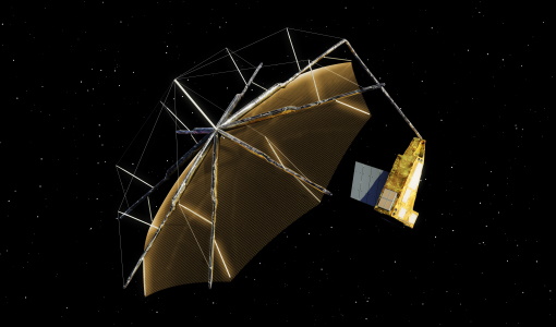
An overview of the Biomass mission
In this video, Klaus Scipal - Biomass and SMOS Mission Manager - talks about ESA's upcoming Biomass mission.
News - Data Release news
New BorealScat campaign dataset released
A new dataset has been released for the BorealScat campaign, which took place between 2017 and 2021 in Sweden.
Data - Data Description
Landsat 7 ETM+ European and Mediterranean Countries Cloud Free Collection
This dataset contains the cloud-free products from Landsat 7 Enhanced Thematic Mapper collection acquired over Europe, North Africa and the Middle East; for each scene only one product is selected, with the minimal cloud coverage. The Landsat 7 ETM+ scenes typically cover 185 x 170 km. A standard full scene is nominally centred on the intersection between a Path and Row (the actual image centre can vary by up to 100 m). The data are system corrected.
Data - EO Sign In Authentication (Open)
Landsat 5 TM European and Mediterranean Countries Cloud Free Collection
This dataset contains the cloud-free products from Landsat 5 Thematic Mapper collection acquired over Europe, North Africa and the Middle East; for each scene only one product is selected, with the minimal cloud coverage. The acquired Landsat TM scene covers approximately 183 x 172.8 km. A standard full scene is nominally centred on the intersection between a path and row (the actual image centre can vary by up to 100 m). The data are system corrected.
Data - EO Sign In Authentication (Open)
Landsat 8 Collection 2 European Coverage
This dataset contains the European coverage of Landsat-8 Collection 2 data, both Level-1 and Level-2, acquired since the beginning of the mission. Landsat-8 Collection 2 is the result of a reprocessing effort on the archive and on newly acquired products with significant improvement with respect to Collection 1 on data quality, obtained by means of advancements in data processing and algorithm development. Primarily, this involves a relevant improvement in the absolute geolocation accuracy (now re-baselined to the European Space Agency Copernicus Sentinel-2 Global Reference Image (GRI) but also includes updated digital elevation modelling sources, improved Radiometric Calibration (even correction for the TIRS striping effect), enhanced Quality Assessment Bands, updated and consistent metadata files and usage of Cloud Optimised Georeferenced (COG) Tagged Image File Format. Landsat-8 Level-1 products combine data from the two Landsat instruments, OLI and TIRS. The Level-1 products generated can be either L1TP or L1GT: L1TP - Level-1 Precision Terrain (Corrected) (L1T) products: Radiometrically calibrated and orthorectified using ground control points (GCPs) and digital elevation model (DEM) data to correct for relief displacement. The highest quality Level-1 products suitable for pixel-level time series analysis. GCPs used for L1TP correction are derived from the Global Land Survey 2000 (GLS2000) data set. L1GT - Level-1 Systematic Terrain (Corrected) (L1GT) products: L1GT data products consist of Level-0 product data with systematic radiometric, geometric and terrain corrections applied and resampled for registration to a cartographic projection, referenced to the WGS84, G873, or current version. The dissemination server contains three different classes of Level-1 products Real Time (RT): Newly acquired Landsat-8 OLI/TIRS data are processed upon downlink but use an initial TIRS line-of-sight model parameters; the data are made available in less than 12 hours (4-6 hours typically). Once the data have been reprocessed with the refined TIRS parameters, the products are transitioned to either Tier 1 or Tier 2 and removed from the Real-Time tier (in 14-16 days). Tier 1 (T1): Landsat scenes with the highest available data quality are placed into Tier 1 and are considered suitable for time-series analysis. Tier 1 includes Level-1 Precision and Terrain (L1TP) corrected data that have well-characterized radiometry and are inter-calibrated across the different Landsat instruments. The georegistration of Tier 1 scenes is consistent and within prescribed image-to-image tolerances of ≦ 12-metre radial root mean square error (RMSE). Tier 2 (T2): Landsat scenes not meeting Tier 1 criteria during processing are assigned to Tier 2. Tier 2 scenes adhere to the same radiometric standard as Tier 1 scenes, but do not meet the Tier 1 geometry specification due to less accurate orbital information (specific to older Landsat sensors), significant cloud cover, insufficient ground control, or other factors. This includes Systematic Terrain (L1GT) and Systematic (L1GS) processed data. Landsat-8 Level-2 products are generated from L1GT and L1TP Level-1 products that meet the <76 degrees Solar Zenith Angle constraint and include the required auxiliary data inputs to generate a scientifically viable product. The data are available a couple of days after the Level-1 T1/T2. The Level-2 products generated can be L2SP or L2SR: L2SP - Level-2 Science Products (L2SP) products: include Surface Reflectance (SR), Surface Temperature (ST), ST intermediate bands, an angle coefficients file, and Quality Assessment (QA) Bands. L2SR - Level-2 Surface Reflectance (L2SR) products: include Surface Reflectance (SR), an angle coefficients file, and Quality Assessment (QA) Bands; it is generated if ST could not be generated. Two different categories of Level-1 products are offered: LC with Optical, Thermal and Quality Map images, LO with Optical and Quality Map images (Thermal not available). For the Level-2 data, only LC combined products are generated.
Data - EO Sign In Authentication (Open)
Landsat ETM+ ESA archive
This dataset contains all the Landsat-7 Enhanced Thematic Mapper high-quality ortho-rectified L1T products (or L1Gt where not enough GCPs are available) over Kiruna, Maspalomas, Matera and Neustrelitz visibility masks. The Landsat-7 ETM+ scenes typically covers 185 x 170 km. A standard full scene is nominally centred on the intersection between a Path and Row (the actual image centre can vary by up to 100 m). Each band requires 50 MB (uncompressed), and Band 8 requires 200 MB (panchromatic band with resolution of 15 m opposed to 30 m). Kiruna, Maspalomas and Matera Landsat-7 ETM density maps
Data - Data Description
Landsat TM ESA archive
This dataset contains all the Landsat-5 Thematic Mapper high-quality ortho-rectified L1T dataset acquired by ESA over the Fucino, Matera, Kiruna and Maspalomas visibility masks, as well as campaign data over Malindi, Bishkek, Chetumal, and Libreville. The acquired Landsat TM scene covers approximately 183 x 172.8 km. A standard full scene is nominally centred on the intersection between a path and row (the actual image centre can vary by up to 100 m). A full image is composed of 6920 pixels x 5760 lines and each band requires 40 MB of storage space (uncompressed) at 30 m spatial resolution in the VIS, NIR and SWIR as well as 120 m in the TIR spectral range. Kiruna Landsat TM GTC density map Maspalomas Landsat TM GTC density map Matera Landsat TM GTC density map
News - Success Stories
ESA's open source computing project for the Biomass mission goes live
The Biomass Product Algorithm Laboratory (BioPAL) is an open-source scientific computing project, which supports the development of ESA’s Biomass mission algorithms coded in Python.
Mission - Third Party Missions

COSMO-SkyMed Second Generation
COSMO-SkyMed Second Generation is at the forefront of radar technology, will ensure improvements and guarantee continuity with the First Generation CSK satellites, preserving the high quality and the highest precision features, both required for the interferometric activities.
News - Success Stories

Drone-based Laser Scanning of Tropical Forests for Biomass Cal/Val
ESA’s upcoming mission Biomass will deliver valuable P-band SAR data aimed at forest aboveground biomass (AGB) estimation across the humid tropics.
Tools - Other

Forestry TEP
The Forestry Thematic Exploitation Platform (TEP) enables users in the forestry sector to access satellite data based processing services and tools for generating value-added forest information products.
Campaign
FIRMOS
In preparation of the Earth Explorer 9 FORUM mission, a new facility named FIRMOS (Far-Infrared Radiation Mobile Observation System) has been developed for field applications from both ground-based and airborne platforms to check with real measurements the sounding capability provided by FIR observations.
Event - Training

10th Advanced Training Course on Land Remote Sensing EO and AI for Forestry
This ESA course was dedicated to training the next generation of EO scientists and experts working in forestry domain to exploit data from EO missions and use AI for science and applications development.