- Data
- Landsat TM ESA archive
Landsat TM ESA archive
Navigate To
How to Access Data
EO Sign In Authentication (Open): This collection is openly accessible but requires users to log in with an EO Sign In account (a system used across ESA Earth Observation services) before any downloads can proceed.
Access Steps:
- Create or log in to EO Sign In account.
- Go to the Dissemination Service or Exploring Earth service.
- Browse or search for the collection.
- Download product.
Products can be downloaded using the following methods:
- HTTPS (via web browser or download manager).
- Exploring Earth service (graphical interface for interactive search and retrieval).
Available to Residents of the Following Countries
Collection Description
This dataset contains all the Landsat-5 Thematic Mapper (TM) high-quality ortho-rectified Level 1 (L1T) dataset acquired by ESA over the Fucino, Matera, Kiruna and Maspalomas visibility masks, as well as campaign data over Malindi, Bishkek, Chetumal, and Libreville.
The acquired Landsat TM scene covers approximately 183 x 172.8 km. A standard full scene is nominally centred on the intersection between a path and row (the actual image centre can vary by up to 100 m).
Image characteristics:
- full image is composed of 6920 pixels x 5760 lines,
- each band requires 40 MB of storage space (uncompressed),
- spatial resolution:
- 30 m in the VIS, NIR and SWIR,
- 120 m in the TIR.
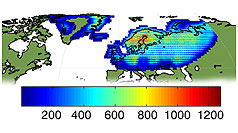
Kiruna Landsat TM GTC density map
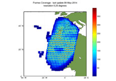
Maspalomas Landsat TM GTC density map
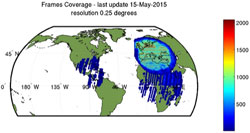
Matera Landsat TM GTC density map
Technical Details
DATA SET SPECIFICATIONS
- European Space Agency, 2021, Landsat TM ESA archive, Version SLAP_03.08https://doi.org/10.57780/esa-b667eb7
PROCESSING LEVEL
DATA CITATION
Having Problems Accessing Data?
Resources
Discover Latest Data

Announcement of opportunity for FLEX cal/val

CryoSat Ocean Level 1
The CryoSat Ocean Processor (COP) generates Ocean products from L0 LRM, SAR and SARIn products. These products are dedicated to the study…

CryoSat Ice Level 2
The Level-2 CryoSat Ice Processor generates Ice products from the L1B LRM, SAR and SARIn products. These products are primarily designed …
CryoTEMPO
CryoSat-2 ThEMatic PrOducts (Cryo-TEMPO) are dedicated products covering five distinct thematic areas: Winter Sea Ice, Summer Sea Ice, Sn…