- All Categories (25)
- Data (2)
- News (5)
- Missions (5)
- Tools (2)
- Documents (11)
News - Thematic area articles
Remote sensing data map impacts of natural hazards
As climate change increases the frequency and severity of natural disasters, remote sensing data can warn about extreme events and help tackle emergency situations.
News - Infographics
Showcasing the atmosphere-studying Odin mission
Learn about the Odin mission in our new infographic.
News - Success Stories

Atmosphere-studying Odin mission enjoys ongoing success
More than two decades after it began operations, the Odin remote sensing satellite is continuing to make strong contributions to high-impact atmospheric science.
Tools - Catalogues

FedEO
FedEO is a data catalogue that provides a unique entry point to a number of scientific catalogues and services for, but not limited to, European and Canadian missions.
Tools - Catalogues

EO CAT
EO CAT is a data catalogue, offering a Next Generation Earth Observation system designed to manage end-user Earth Observation services.
Data - External Data (Restrained)
Odin OSIRIS data products
The Odin OSIRIS (Optical Spectrograph and Infra-Red Imaging System) data provides vertical profiles measures of spectrally dispersed, limb scattered sunlight from the upper troposphere into the lower mesosphere. The data products are regularly processed and provide Ozone density vertical profiles (both Level 2 and Level 3), vertical profiles of stratospheric Aerosol (both Level 2 and Level 3), slant column densities of nitrogen dioxide NO2 profiles (Level 2), stratospheric BrO profiles (Level 2).
Document - Technical Note

Technical Note on Quality Assessment for OceanSat-2 (7 Oct 20)
Technical Note on Quality Assessment for OceanSat-2 (7 Oct 20)
Document - Technical Note
Technical Note on Quality Assessment for OceanSat-2 (6 Aug 20)
Technical Note on Quality Assessment for OceanSat-2 (6 Aug 20)
Document - Technical Note
Technical Note on Quality Assessment for OceanSat-2 (1 Jan 19)
Technical Note on Quality Assessment for OceanSat 2 OCM (Quarterly report for Q4 2018)
Document - Technical Note
Technical Note on Quality Assessment for OceanSat-2 (4 Jan 20)
Technical Note on Quality Assessment for OceanSat-2 OCM (Quarterly report for Q3 and Q4 2019)
Document - Technical Note
Technical Note on Quality Assessment for OceanSat-2 (3 Jul 19)
Technical Note on Quality Assessment for OceanSat 2 OCM (Quarterly report for Q2 2019)
Document - Technical Note
Technical Note on Quality Assessment for OceanSat-2 (5 May 20)
Technical Note on Quality Assessment for OceanSat-2 OCM (Quarterly report for Q1 2020)
Document - Technical Note
Technical Note on Quality Assessment for OceanSat-2 (2 Apr 19)
Technical Note on Quality Assessment for OceanSat-2 OCM (Quarterly report for Q1 2019)
Data - EO Sign In Authentication (Open)
OceanSat-2 data
ESA, in collaboration with GAF AG, acquired and processed every day OceanSat-2 passes over Neutrelitz reception station from January 2016 to November 2021. All passes were systematically processed to levels 1B, 2B and 2C, and available to users in NRT (< 3 hours). Products are available in: Level 1B: Geophysical Data containing Radiance Data for all 8 Bands of OCM-2 Level 2B: Geophysical Data L2B for given Geo physical parameter. Geo physical parameters: Chlorophyll, Aerosol Depth, Different Attenuation, Total Suspended Sediments Level 2C: Georeferenced Radiance Data for given geo physical parameter. Geo physical parameters: Chlorophyll, Aerosol Depth, Different Attenuation, Total Suspended Sediments. Spatial coverage: Check the spatial coverage of the collection on a map available on the Third Party Missions Dissemination Service.
Mission - Heritage Missions

IRS-1C and IRS-1D
The Indian Remote Sensing satellites IRS-1C and IRS-1D were identical Earth-imaging satellites operated by the Indian Space Research Organisation.
News - Success Stories

Odin celebrates 18 years in orbit
ESA is proud to celebrate the excellent long-lasting performance of the Swedish-led Odin mission.
News - Data Release news

ESA will continue to provide ocean colour data from Indian mission
To further promote research and applications, ESA and a leading geo-information company agree to continue data acquisition from OceanSat-2.
Mission - Third Party Missions
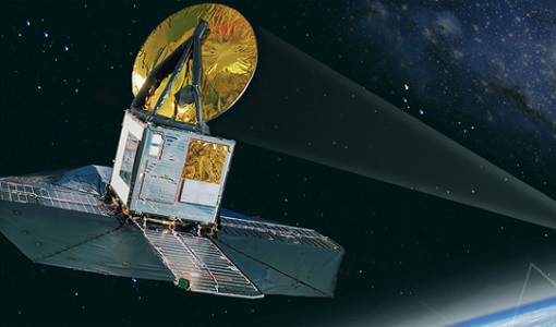
Odin
Odin is an atmosphere-studying satellite mission from Sweden, Canada, France and Finland.
Mission - Third Party Missions

OceanSat-2
OceanSat-2 provides service continuity for the operational users of the OCM (Ocean Colour Monitor) instrument launched in 1999 on board the predecessor IRS-P4/OceanSat-1 mission.
Mission - Heritage Missions

IRS-1D
IRS-1D was part of the IRS (Indian Remote Sensing) satellites, a large family of Earth observation satellites operated by ISRO.